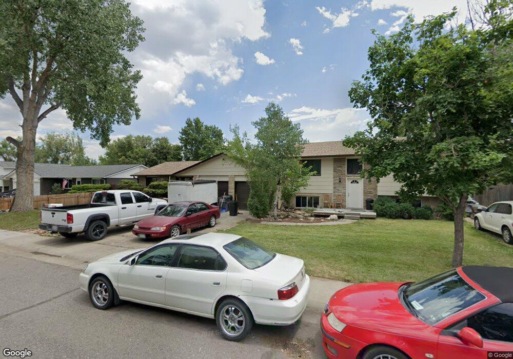
4604 Simms St Wheat Ridge, CO 80033
Fruitdale NeighborhoodEstimated Value: $706,000 - $797,000
4
Beds
3
Baths
1,795
Sq Ft
$416/Sq Ft
Est. Value
About This Home
This home is located at 4604 Simms St, Wheat Ridge, CO 80033 and is currently estimated at $746,320, approximately $415 per square foot. 4604 Simms St is a home located in Jefferson County with nearby schools including Prospect Valley Elementary School, Everitt Middle School, and Wheat Ridge High School.
Ownership History
Date
Name
Owned For
Owner Type
Purchase Details
Closed on
Aug 20, 2015
Sold by
Jasiewicz Rose
Bought by
Jasiewicz Rose and Liang Jessica
Current Estimated Value
Purchase Details
Closed on
Nov 30, 2012
Sold by
Dynasty Enterprise Llc
Bought by
Jasiewicz Rose
Purchase Details
Closed on
Nov 29, 2012
Sold by
Connolly Kurt J and Hobson Darl G
Bought by
Dynasty Enterprise Llc
Purchase Details
Closed on
Oct 6, 2011
Sold by
Johlgren Jeffrey E and Yunker Dolores
Bought by
Hobson/Idlewild Investments
Create a Home Valuation Report for This Property
The Home Valuation Report is an in-depth analysis detailing your home's value as well as a comparison with similar homes in the area
Home Values in the Area
Average Home Value in this Area
Purchase History
| Date | Buyer | Sale Price | Title Company |
|---|---|---|---|
| Jasiewicz Rose | -- | None Available | |
| Jasiewicz Rose | $280,000 | Land Title Guarantee Company | |
| Dynasty Enterprise Llc | -- | Land Title Guarantee Company | |
| Hobson/Idlewild Investments | -- | None Available |
Source: Public Records
Tax History
| Year | Tax Paid | Tax Assessment Tax Assessment Total Assessment is a certain percentage of the fair market value that is determined by local assessors to be the total taxable value of land and additions on the property. | Land | Improvement |
|---|---|---|---|---|
| 2024 | $4,124 | $44,901 | $24,009 | $20,892 |
| 2023 | $4,124 | $44,901 | $24,009 | $20,892 |
| 2022 | $3,081 | $33,215 | $15,239 | $17,976 |
| 2021 | $3,198 | $34,925 | $16,024 | $18,901 |
| 2020 | $2,779 | $30,381 | $13,506 | $16,875 |
| 2019 | $2,740 | $30,381 | $13,506 | $16,875 |
| 2018 | $2,363 | $25,456 | $8,099 | $17,357 |
| 2017 | $2,153 | $25,456 | $8,099 | $17,357 |
| 2016 | $2,261 | $25,006 | $7,367 | $17,639 |
| 2015 | $1,144 | $25,006 | $7,367 | $17,639 |
| 2014 | $2,093 | $21,750 | $5,846 | $15,904 |
Source: Public Records
Map
Nearby Homes
- 11772 W 45th Place
- 11691 W 45th Place
- 4615 Quail St
- 11719 W 45th Place
- 4695 Parfet St
- 4303 Quail St Unit 8A
- 5188 Rob Way
- 5182 Rob Way
- 11890 W 52nd Ave
- 5192 Rob Way
- 11590 W 39th Place
- 12323 Ridge Rd
- 5218 Routt St Unit A
- 5240 Routt Ct Unit B
- 12340 W 51st Ave
- 3935 Pierson St
- 5181 Vivian St
- 12336 W 52nd Ave
- 10251 W 44th Ave Unit 5-208
- 10251 W 44th Ave Unit 6-106
Your Personal Tour Guide
Ask me questions while you tour the home.