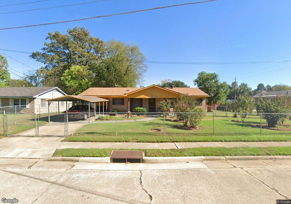
4605 Curtis Ln Shreveport, LA 71109
Mooretown and Hollywood Heights NeighborhoodEstimated Value: $51,000 - $87,000
3
Beds
2
Baths
913
Sq Ft
$73/Sq Ft
Est. Value
About This Home
This home is located at 4605 Curtis Ln, Shreveport, LA 71109 and is currently estimated at $67,052, approximately $73 per square foot. 4605 Curtis Ln is a home with nearby schools including Oak Park Elementary School, Judson Fundamental Elementary School, and Fairfield Magnet School.
Ownership History
Date
Name
Owned For
Owner Type
Purchase Details
Closed on
Sep 7, 2010
Sold by
Ferdinand Larry
Bought by
Johnson Johnny Linn and Johnson Rosie Dunking
Current Estimated Value
Purchase Details
Closed on
Mar 15, 2010
Sold by
Bank Of America Na
Bought by
Ferdiand Larry
Purchase Details
Closed on
Jul 29, 2009
Sold by
Estate Of Ella Alberta Frazier
Bought by
Bank Of America Na
Purchase Details
Closed on
Jun 14, 2007
Sold by
Central Properties
Bought by
Bella Lago Llc
Purchase Details
Closed on
Jun 2, 2006
Sold by
Brooks Lillie Terrell and Brooks Jerry T
Bought by
Central Properties Us Bank
Create a Home Valuation Report for This Property
The Home Valuation Report is an in-depth analysis detailing your home's value as well as a comparison with similar homes in the area
Home Values in the Area
Average Home Value in this Area
Purchase History
| Date | Buyer | Sale Price | Title Company |
|---|---|---|---|
| Johnson Johnny Linn | $60,650 | None Available | |
| Ferdiand Larry | $32,000 | None Available | |
| Bank Of America Na | $36,667 | None Available | |
| Bank Of America Na | $36,667 | None Available | |
| Bella Lago Llc | $250 | None Available | |
| Central Properties Us Bank | $728 | None Available |
Source: Public Records
Tax History Compared to Growth
Tax History
| Year | Tax Paid | Tax Assessment Tax Assessment Total Assessment is a certain percentage of the fair market value that is determined by local assessors to be the total taxable value of land and additions on the property. | Land | Improvement |
|---|---|---|---|---|
| 2024 | $1,074 | $6,892 | $588 | $6,304 |
| 2023 | $996 | $6,250 | $560 | $5,690 |
| 2022 | $996 | $6,250 | $560 | $5,690 |
| 2021 | $981 | $6,250 | $560 | $5,690 |
| 2020 | $981 | $6,250 | $560 | $5,690 |
| 2019 | $971 | $6,007 | $560 | $5,447 |
| 2018 | $0 | $6,007 | $560 | $5,447 |
| 2017 | $987 | $6,007 | $560 | $5,447 |
| 2015 | -- | $6,110 | $560 | $5,550 |
| 2014 | -- | $6,110 | $560 | $5,550 |
| 2013 | -- | $6,110 | $560 | $5,550 |
Source: Public Records
Map
Nearby Homes
- 4310 Saint Louis Ave
- 4302 Illinois Ave
- 4513 Rochester Dr
- 4814 Mcdaniel Dr
- 5717 Fallowmont St
- 5600 Norton St
- 4144 Clover St
- 5222 Broadway Ave
- 3 Broadway Ave
- 2 Broadway Ave
- 1 Broadway Ave
- 4209 Lamar Ave
- 4138 Powell St
- 4710 Erin Ln
- 3735 Tate St
- 4144 Marston Ave
- 4136 Mayfield St
- 4130 Mayfield St
- 3841 Flora Ave
- 4738 3l Westwood Park Dr
- 4601 Curtis Ln
- 4364 Illinois Ave
- 4369 Walter St
- 4362 Illinois Ave
- 4359 Saint Louis Ave
- 4359 Saint Louis Ave
- 4360 Illinois Ave
- 4370 Walter St
- 4373 Walter St
- 4357 Saint Louis Ave
- 4355 Saint Louis Ave
- 4358 Illinois Ave
- 4372 Walter St
- 4614 Curtis Ln
- 4353 Saint Louis Ave
- 4375 Walter St
- 4356 Illinois Ave
- 4610 Curtis Ln
- 4374 Walter St
- 4377 Walter St