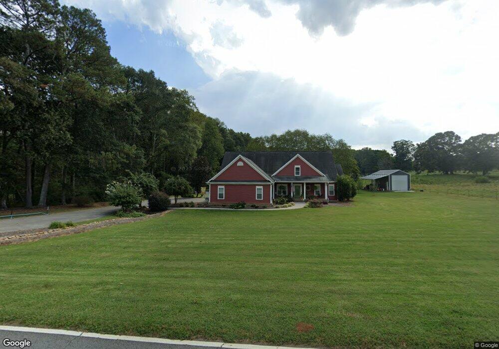
461 Nugget Rd Carrollton, GA 30117
Estimated Value: $551,000 - $639,000
5
Beds
3
Baths
4,022
Sq Ft
$147/Sq Ft
Est. Value
About This Home
This home is located at 461 Nugget Rd, Carrollton, GA 30117 and is currently estimated at $590,622, approximately $146 per square foot. 461 Nugget Rd is a home located in Carroll County with nearby schools including Roopville Elementary School, Central Middle School, and Central High School.
Ownership History
Date
Name
Owned For
Owner Type
Purchase Details
Closed on
Nov 15, 2012
Sold by
Muse Donald
Bought by
Muse Donald and Muse Tammy
Current Estimated Value
Purchase Details
Closed on
Jun 22, 2012
Sold by
Muse Tammy N
Bought by
Muse Donald N
Purchase Details
Closed on
Jan 16, 2009
Sold by
Muse Donald N
Bought by
Muse Tammy N
Purchase Details
Closed on
Oct 30, 2006
Sold by
Muse Donald N
Bought by
Kenerly Farnk D
Purchase Details
Closed on
Dec 17, 2004
Sold by
North Donald
Bought by
North Joyce
Purchase Details
Closed on
May 1, 2004
Bought by
North Donald
Create a Home Valuation Report for This Property
The Home Valuation Report is an in-depth analysis detailing your home's value as well as a comparison with similar homes in the area
Home Values in the Area
Average Home Value in this Area
Purchase History
| Date | Buyer | Sale Price | Title Company |
|---|---|---|---|
| Muse Donald | -- | -- | |
| Muse Donald N | -- | -- | |
| Muse Tammy N | -- | -- | |
| Kenerly Farnk D | $245,000 | -- | |
| North Joyce | -- | -- | |
| North Donald | -- | -- |
Source: Public Records
Tax History Compared to Growth
Tax History
| Year | Tax Paid | Tax Assessment Tax Assessment Total Assessment is a certain percentage of the fair market value that is determined by local assessors to be the total taxable value of land and additions on the property. | Land | Improvement |
|---|---|---|---|---|
| 2024 | $4,090 | $220,000 | $5,340 | $214,660 |
| 2023 | $4,090 | $236,512 | $5,076 | $231,436 |
| 2022 | $3,926 | $189,010 | $3,384 | $185,626 |
| 2021 | $3,525 | $161,337 | $2,707 | $158,630 |
| 2020 | $3,219 | $144,175 | $2,461 | $141,714 |
| 2019 | $2,991 | $130,440 | $2,461 | $127,979 |
| 2018 | $2,652 | $109,648 | $2,300 | $107,348 |
| 2017 | $2,659 | $109,648 | $2,300 | $107,348 |
| 2016 | $2,660 | $109,648 | $2,300 | $107,348 |
| 2015 | $2,540 | $94,810 | $4,142 | $90,668 |
| 2014 | $2,550 | $94,810 | $4,142 | $90,668 |
Source: Public Records
Map
Nearby Homes
- 195 Gold Dust Trail
- 0 Bonner Goldmine Rd Unit 145631
- 0 Bonner Goldmine Rd Unit 10433818
- 191 Tumlin Creek Rd
- 0 Ringer Rd Unit 10595950
- 915 Oak Grove Rd
- 2492 Oak Grove Church Rd
- 0 Lowell Rd Unit 10640679
- 00 Ringer Rd
- 0 Louise Ln Unit 10563364
- 1575 Bethesda Church Rd
- 1593 Bethesda Church Rd
- 2088 Star Point Rd
- 1611 Bethesda Church Rd
- 1629 Bethesda Church Rd
- 221 Valley Ridge Dr
- 484 Carrie Kathleen Terrace
- 0 W Highway 5 Unit 10519663
- 301 E Highway 5
- 472 Carrie Kathleen Terrace
- 454 Nugget Rd
- 435 Nugget Rd
- 389 Nugget Rd
- 551 Nugget Rd
- 551 Nugget Rd
- 1400 Oak Grove Church Rd
- 1440 Oak Grove Church Rd
- 330 Gold Dust Trail
- 320 Gold Dust Trail
- 1350 Oak Grove Church Rd
- 1350 Oak Grove Chruch Rd
- 1427 Oak Grove Church Rd
- 335 Gold Dust Trail
- 310 Gold Dust Trail
- 141 Nugget Rd Unit 67
- 141 Nugget Rd
- 0 Nugget Rd Unit 8891885
- 0 Nugget Rd Unit 8665639
- 0 Nugget Rd Unit 7310774
- 0 Nugget Rd