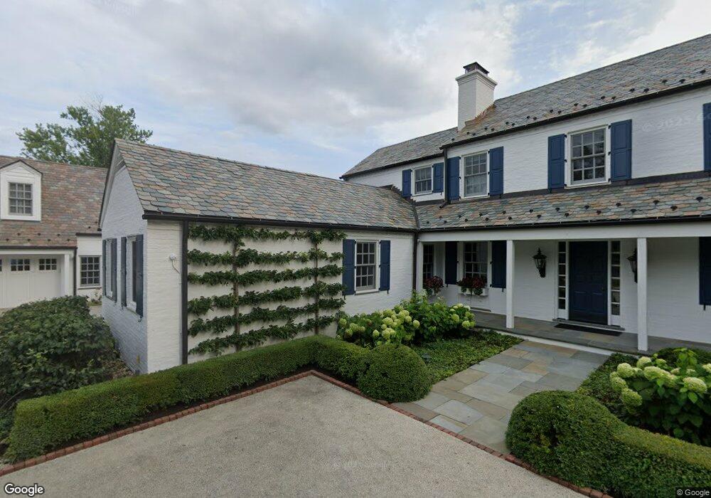
461 Stable Ln Lake Forest, IL 60045
Estimated Value: $2,258,000 - $3,057,492
5
Beds
7
Baths
5,979
Sq Ft
$439/Sq Ft
Est. Value
About This Home
This home is located at 461 Stable Ln, Lake Forest, IL 60045 and is currently estimated at $2,623,497, approximately $438 per square foot. 461 Stable Ln is a home located in Lake County with nearby schools including Cherokee Elementary School, Deer Path Middle School East, and Lake Forest High School.
Ownership History
Date
Name
Owned For
Owner Type
Purchase Details
Closed on
May 8, 2012
Sold by
Kaufman Andrew M and Kaufman Michele M
Bought by
Sannes Andrew John and Sannes Heather Elise
Current Estimated Value
Purchase Details
Closed on
Apr 14, 1994
Sold by
Harris Bank Glencoe Northbrook Na
Bought by
Kaufman Andrew M and Kaufman Michele M
Home Financials for this Owner
Home Financials are based on the most recent Mortgage that was taken out on this home.
Original Mortgage
$715,000
Interest Rate
7.12%
Create a Home Valuation Report for This Property
The Home Valuation Report is an in-depth analysis detailing your home's value as well as a comparison with similar homes in the area
Home Values in the Area
Average Home Value in this Area
Purchase History
| Date | Buyer | Sale Price | Title Company |
|---|---|---|---|
| Sannes Andrew John | $1,735,000 | None Available | |
| Kaufman Andrew M | $850,000 | Chicago Title Insurance Co | |
| Harris Bank Glencoe-Northbrook N A | -- | Chicago Title Insurance Co |
Source: Public Records
Mortgage History
| Date | Status | Borrower | Loan Amount |
|---|---|---|---|
| Previous Owner | Kaufman Andrew M | $715,000 |
Source: Public Records
Tax History Compared to Growth
Tax History
| Year | Tax Paid | Tax Assessment Tax Assessment Total Assessment is a certain percentage of the fair market value that is determined by local assessors to be the total taxable value of land and additions on the property. | Land | Improvement |
|---|---|---|---|---|
| 2024 | $41,749 | $703,575 | $239,164 | $464,411 |
| 2023 | $40,840 | $675,216 | $229,524 | $445,692 |
| 2022 | $40,840 | $686,198 | $241,741 | $444,457 |
| 2021 | $38,619 | $661,587 | $233,071 | $428,516 |
| 2020 | $37,617 | $662,979 | $233,561 | $429,418 |
| 2019 | $34,990 | $661,854 | $233,165 | $428,689 |
| 2018 | $45,297 | $890,263 | $247,135 | $643,128 |
| 2017 | $44,430 | $887,424 | $246,347 | $641,077 |
| 2016 | $40,752 | $810,129 | $237,032 | $573,097 |
| 2015 | $40,116 | $736,631 | $222,712 | $513,919 |
| 2014 | $31,517 | $570,588 | $224,306 | $346,282 |
| 2012 | $29,571 | $565,554 | $222,327 | $343,227 |
Source: Public Records
Map
Nearby Homes
- 740 W Tamarack Trail
- 725 W Tamarack Trail
- 765 W Tamarack Trail
- 755 W Tamarack Trail
- 355 Hickory Ct
- 210 Majestic Oak Ct
- 560 Jacqulyn Ln
- 50 S Orchard Cir
- 931 Coventry Dr
- 1031 Barrys Ct
- 1036 Barrys Ct
- 510 Buena Rd
- Lot 5 Whitehall Ln
- Lot 7 Whitehall Ln
- Lot 8 Whitehall Ln
- Lot 6 Whitehall Ln
- Lot 9 Whitehall Ln
- 1130 Gavin Ct
- 51 Heron Rd
- 1161 Gavin Ct
- 491 Stable Ln
- 555 W Westleigh Rd
- 464 S Ridge Rd
- 625 W Westleigh Rd
- 521 Stable Ln
- 470 Stable Ln
- 500 S Ridge Rd
- 424 S Ridge Rd
- 500 Stable Ln
- 434 Stable Ln
- 590 Broadsmoore Dr
- 590 Broadsmoore Dr
- 530 S Ridge Rd
- 630 W Westleigh Rd
- 600 W Westleigh Rd
- 580 Broadsmoore Dr
- 550 Stable Ln
- 433 S Ridge Rd
- 765 W Westleigh Rd
- 551 Stable Ln