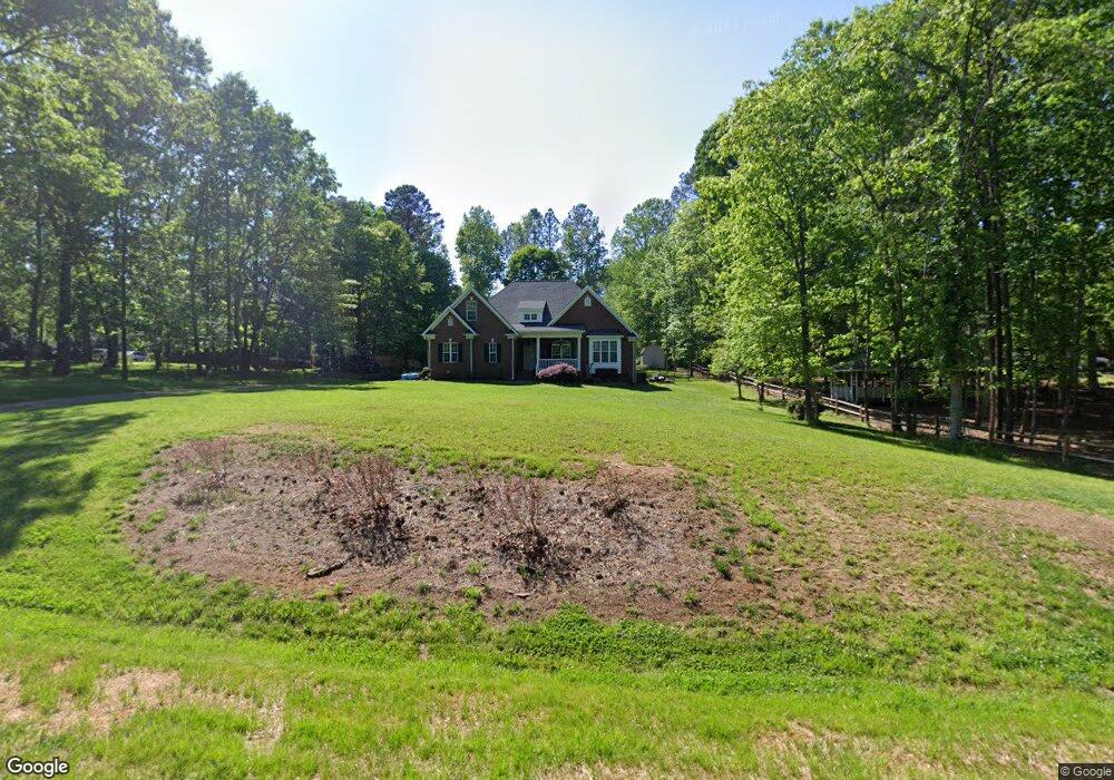
4610 Ferguson Cir Waxhaw, NC 28173
Estimated Value: $517,000 - $610,000
3
Beds
2
Baths
2,308
Sq Ft
$245/Sq Ft
Est. Value
About This Home
This home is located at 4610 Ferguson Cir, Waxhaw, NC 28173 and is currently estimated at $566,594, approximately $245 per square foot. 4610 Ferguson Cir is a home located in Union County with nearby schools including Waxhaw Elementary School, Parkwood Middle School, and Parkwood High School.
Ownership History
Date
Name
Owned For
Owner Type
Purchase Details
Closed on
Oct 26, 2005
Sold by
Blakeney Jamie S and Blakeney Libra D
Bought by
Mullis Wimbish Thomas Louis and Mullis Wimbish Angela
Current Estimated Value
Home Financials for this Owner
Home Financials are based on the most recent Mortgage that was taken out on this home.
Original Mortgage
$154,000
Outstanding Balance
$82,930
Interest Rate
5.76%
Mortgage Type
Fannie Mae Freddie Mac
Estimated Equity
$483,664
Purchase Details
Closed on
Jan 20, 2003
Sold by
Blue Sky Properties Of N Carolina Llc
Bought by
Blakeney Jamie S and Blakeney Libra D
Home Financials for this Owner
Home Financials are based on the most recent Mortgage that was taken out on this home.
Original Mortgage
$34,200
Interest Rate
6.16%
Purchase Details
Closed on
Oct 1, 2002
Sold by
Frick Douglas G and Frick Judy S
Bought by
Blue Sky Properties Of N Carolina Llc
Create a Home Valuation Report for This Property
The Home Valuation Report is an in-depth analysis detailing your home's value as well as a comparison with similar homes in the area
Home Values in the Area
Average Home Value in this Area
Purchase History
| Date | Buyer | Sale Price | Title Company |
|---|---|---|---|
| Mullis Wimbish Thomas Louis | $240,000 | -- | |
| Blakeney Jamie S | $39,000 | -- | |
| Blue Sky Properties Of N Carolina Llc | $494,000 | -- |
Source: Public Records
Mortgage History
| Date | Status | Borrower | Loan Amount |
|---|---|---|---|
| Open | Mullis Wimbish Thomas Louis | $154,000 | |
| Previous Owner | Blakeney Jamie S | $34,200 |
Source: Public Records
Tax History Compared to Growth
Tax History
| Year | Tax Paid | Tax Assessment Tax Assessment Total Assessment is a certain percentage of the fair market value that is determined by local assessors to be the total taxable value of land and additions on the property. | Land | Improvement |
|---|---|---|---|---|
| 2024 | $2,248 | $351,100 | $50,000 | $301,100 |
| 2023 | $2,212 | $351,100 | $50,000 | $301,100 |
| 2022 | $2,212 | $351,100 | $50,000 | $301,100 |
| 2021 | $2,196 | $349,500 | $50,000 | $299,500 |
| 2020 | $2,101 | $268,100 | $36,400 | $231,700 |
| 2019 | $2,106 | $268,100 | $36,400 | $231,700 |
| 2018 | $2,106 | $268,100 | $36,400 | $231,700 |
| 2017 | $2,205 | $268,100 | $36,400 | $231,700 |
| 2016 | $2,151 | $268,100 | $36,400 | $231,700 |
| 2015 | $2,184 | $268,100 | $36,400 | $231,700 |
| 2014 | $1,899 | $270,440 | $56,000 | $214,440 |
Source: Public Records
Map
Nearby Homes
- 4607 Ferguson Cir
- 0 Rockwood Dr
- 4010 Cedar Falls Dr
- 3010 Cedar Falls Dr
- 1017 Cheviot Ct
- 2028 Cedar Falls Dr
- 3025 Cedar Falls Dr
- 3013 Whipcord Dr
- 1009 Cheviot Ct
- 3009 Lydney Cir
- 2004 Whipcord Dr
- 5026 Mclaughlin Loop
- Colfax Plan at Rone Creek
- Charleston Plan at Rone Creek
- Hamilton Plan at Rone Creek
- Sullivan Plan at Rone Creek
- Davidson Plan at Rone Creek
- Edgefield Plan at Rone Creek
- McDowell Plan at Rone Creek
- Roanoke Plan at Rone Creek
- 4612 Ferguson Cir
- 4608 Ferguson Cir
- 4523 Rockwood Dr
- 4604 Ferguson Cir
- 4519 Rockwood Dr
- 4624 Ferguson Cir
- 4527 Rockwood Dr
- 4515 Rockwood Dr
- 4611 Ferguson Cir
- 4605 Ferguson Cir
- 00 Rockwood Dr
- lot 98 Rockwood Dr
- 4600 Ferguson Cir
- 4511 Rockwood Dr
- 4613 Ferguson Cir
- 4613 Ferguson Cir Unit 47
- 4531 Rockwood Dr
- 4615 Ferguson Cir
- 4601 Ferguson Cir
- 4805 Rockwood Dr