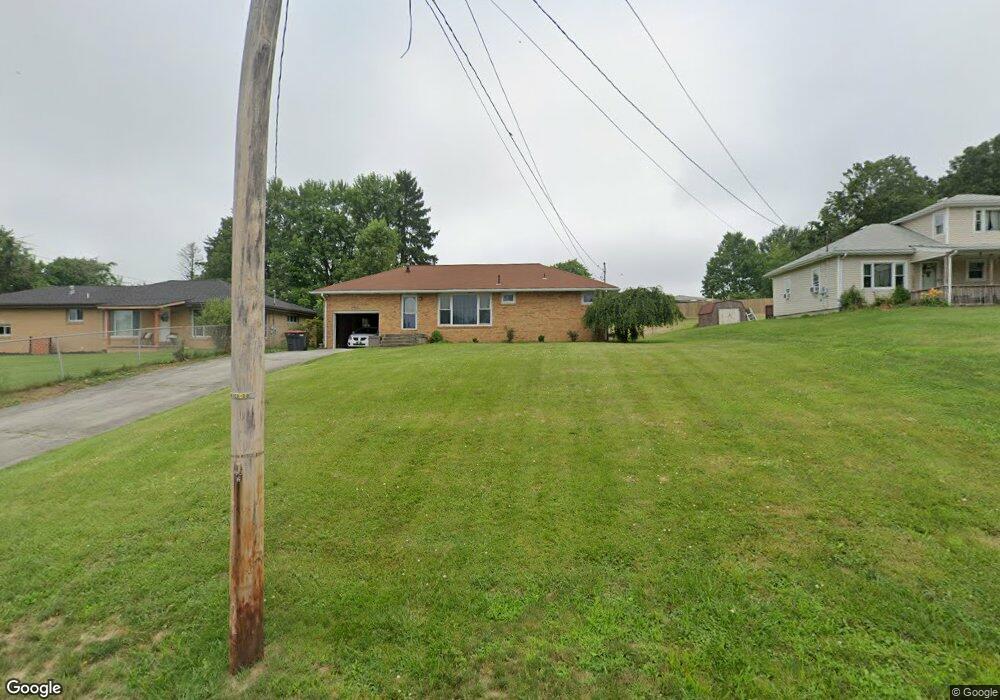
46128 Wyoming Ave East Liverpool, OH 43920
Estimated Value: $130,000 - $157,000
3
Beds
2
Baths
1,040
Sq Ft
$139/Sq Ft
Est. Value
About This Home
This home is located at 46128 Wyoming Ave, East Liverpool, OH 43920 and is currently estimated at $144,617, approximately $139 per square foot. 46128 Wyoming Ave is a home located in Columbiana County with nearby schools including Westgate Middle School, LaCroft Elementary School, and East Liverpool High School.
Ownership History
Date
Name
Owned For
Owner Type
Purchase Details
Closed on
Oct 30, 2023
Sold by
Persohn Michael and Persohn Tanya
Bought by
Ross Karen A
Current Estimated Value
Purchase Details
Closed on
Oct 2, 2002
Sold by
Persohn Kathleen E and Persohn Amy Michelle
Bought by
Persohn David Michael and Persohn Tanya M
Home Financials for this Owner
Home Financials are based on the most recent Mortgage that was taken out on this home.
Original Mortgage
$55,000
Interest Rate
6.39%
Create a Home Valuation Report for This Property
The Home Valuation Report is an in-depth analysis detailing your home's value as well as a comparison with similar homes in the area
Home Values in the Area
Average Home Value in this Area
Purchase History
| Date | Buyer | Sale Price | Title Company |
|---|---|---|---|
| Ross Karen A | $140,000 | None Listed On Document | |
| Persohn David Michael | $40,000 | Union Title Company |
Source: Public Records
Mortgage History
| Date | Status | Borrower | Loan Amount |
|---|---|---|---|
| Previous Owner | Persohn David Michael | $55,000 |
Source: Public Records
Tax History Compared to Growth
Tax History
| Year | Tax Paid | Tax Assessment Tax Assessment Total Assessment is a certain percentage of the fair market value that is determined by local assessors to be the total taxable value of land and additions on the property. | Land | Improvement |
|---|---|---|---|---|
| 2024 | $867 | $33,080 | $4,170 | $28,910 |
| 2023 | $1,232 | $33,080 | $4,170 | $28,910 |
| 2022 | $1,233 | $33,080 | $4,170 | $28,910 |
| 2021 | $1,062 | $26,220 | $3,710 | $22,510 |
| 2020 | $1,064 | $26,220 | $3,710 | $22,510 |
| 2019 | $1,063 | $26,220 | $3,710 | $22,510 |
| 2018 | $999 | $23,000 | $3,260 | $19,740 |
| 2017 | $982 | $23,000 | $3,260 | $19,740 |
| 2016 | $1,088 | $25,210 | $4,520 | $20,690 |
| 2015 | $1,088 | $25,210 | $4,520 | $20,690 |
| 2014 | $1,073 | $25,210 | $4,520 | $20,690 |
Source: Public Records
Map
Nearby Homes
- 46150 Y and O Rd
- 16104 State Route 267
- 45804 Yeager Dr
- 16467 Staunton Ave
- 15782 Vale St
- 1952 Dunn Rd
- 46835 Mary St
- 16573 Annesley Rd
- 17140 Cannons Mill Rd
- 15054 Strader Rd
- 0 Rodaman
- 2492 Irish Ridge Rd
- 15904 E Liverpool Rd
- 46690 Winston Dr
- 16007 Simmons St
- 14614 E Liverpool Rd
- 967 7th Ave
- 14540 Birch Rd
- 602 9th Ave
- 2476 Lisbon St
- 46114 Wyoming Ave
- 46150 Wyoming Ave
- 46129 Wyoming Ave
- 46137 Wyoming Ave
- 46147 Wyoming Ave
- 46117 Wyoming Ave
- 16251 John Ave
- 46161 Wyoming Ave
- 46184 Wyoming Ave
- 16231 John Ave
- 46101 Wyoming Ave
- 46183 Wyoming Ave
- 46183 Wyoming Ave
- 46074 Wyoming Ave
- 46079 Wyoming Ave
- 16240 John Ave
- 16255 Lyle St
- 16221 John Ave
- 46201 Wyoming Ave
- 46137 Ross St