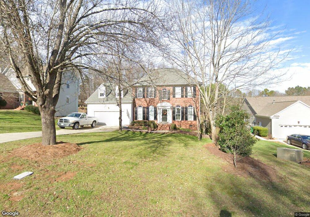
4614 Dellfield Way Charlotte, NC 28269
Prosperity Church Road NeighborhoodEstimated Value: $461,000 - $474,000
4
Beds
3
Baths
2,650
Sq Ft
$177/Sq Ft
Est. Value
About This Home
This home is located at 4614 Dellfield Way, Charlotte, NC 28269 and is currently estimated at $468,189, approximately $176 per square foot. 4614 Dellfield Way is a home located in Mecklenburg County with nearby schools including Croft Community Elementary, Ridge Road Middle School, and Mallard Creek High School.
Ownership History
Date
Name
Owned For
Owner Type
Purchase Details
Closed on
Sep 24, 1998
Sold by
Barbee Diane A and Crow Diane A
Bought by
Kakaley Russell and Kakaley Rebecca
Current Estimated Value
Home Financials for this Owner
Home Financials are based on the most recent Mortgage that was taken out on this home.
Original Mortgage
$150,000
Outstanding Balance
$27,534
Interest Rate
5.25%
Mortgage Type
Purchase Money Mortgage
Estimated Equity
$440,655
Create a Home Valuation Report for This Property
The Home Valuation Report is an in-depth analysis detailing your home's value as well as a comparison with similar homes in the area
Home Values in the Area
Average Home Value in this Area
Purchase History
| Date | Buyer | Sale Price | Title Company |
|---|---|---|---|
| Kakaley Russell | $168,350 | -- |
Source: Public Records
Mortgage History
| Date | Status | Borrower | Loan Amount |
|---|---|---|---|
| Open | Kakaley Russell | $150,000 |
Source: Public Records
Tax History Compared to Growth
Tax History
| Year | Tax Paid | Tax Assessment Tax Assessment Total Assessment is a certain percentage of the fair market value that is determined by local assessors to be the total taxable value of land and additions on the property. | Land | Improvement |
|---|---|---|---|---|
| 2025 | $3,257 | $409,800 | $80,000 | $329,800 |
| 2024 | $3,257 | $409,800 | $80,000 | $329,800 |
| 2023 | $3,145 | $409,800 | $80,000 | $329,800 |
| 2022 | $2,689 | $265,600 | $45,000 | $220,600 |
| 2021 | $2,678 | $265,600 | $45,000 | $220,600 |
| 2020 | $2,670 | $265,700 | $45,000 | $220,700 |
| 2019 | $2,656 | $265,700 | $45,000 | $220,700 |
| 2018 | $2,586 | $191,500 | $35,000 | $156,500 |
| 2017 | $2,542 | $191,500 | $35,000 | $156,500 |
| 2016 | $2,532 | $191,500 | $35,000 | $156,500 |
| 2015 | $2,521 | $191,500 | $35,000 | $156,500 |
| 2014 | $2,522 | $0 | $0 | $0 |
Source: Public Records
Map
Nearby Homes
- 9701 Kent Village Dr
- 9614 Runswyck Ct
- 9608 Runswyck Ct
- 10024 Avon Farm Ln
- 12042 Mallard Ridge Dr
- 4321 Silvermere Way
- 4045 Amber Leigh Way Dr
- 3700 Radbourne Blvd
- 7106 Kinsmore Ln
- 7718 Wiltshire Ridge Rd
- 10101 White Cascade Dr
- 7114 Kinsmore Ln
- 3111 Ewert Cut Ln
- 4306 Wynborough Ln
- 9900 Colvard Cir
- 6712 W Sugar Creek Rd
- 3810 Yorkford Dr
- 6708 W Sugar Creek Rd
- 3127 Colvard Park Way
- 3522 Wylie Meadow Ln
- 4620 Dellfield Way
- 4626 Dellfield Way
- 4606 Dellfield Way
- 4600 Dellfield Way
- 4607 Dellfield Way
- 4621 Dellfield Way
- 4601 Dellfield Way
- 4632 Dellfield Way
- 4627 Dellfield Way
- 4633 Dellfield Way
- 4601 Saxonbury Way
- 4607 Saxonbury Way
- 12438 Mallard Dr
- 4613 Saxonbury Way
- 12442 Mallard Dr
- 3610 Robin Ln
- 12428 Mallard Dr
- 3601 Robin Ln
- 3601 Robin Ln Unit 19
- 4523 Saxonbury Way