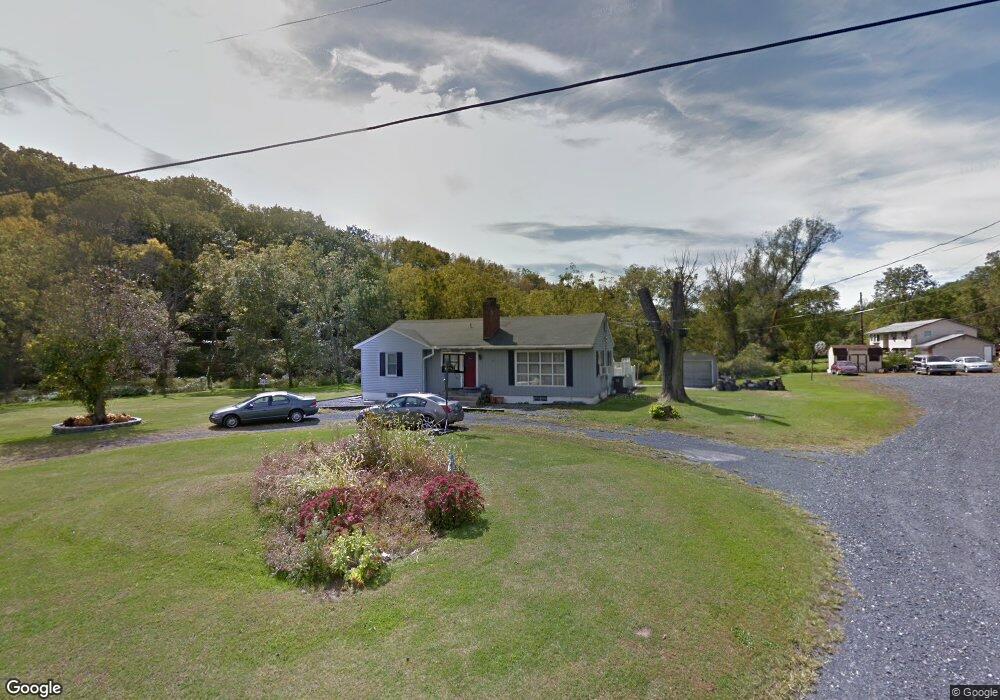
4618 Mulberry St Coplay, PA 18037
Estimated Value: $339,484 - $485,000
3
Beds
1
Bath
1,276
Sq Ft
$305/Sq Ft
Est. Value
About This Home
This home is located at 4618 Mulberry St, Coplay, PA 18037 and is currently estimated at $389,621, approximately $305 per square foot. 4618 Mulberry St is a home located in Lehigh County with nearby schools including Ironton Elementary School, Orefield Middle School, and Parkland High School.
Ownership History
Date
Name
Owned For
Owner Type
Purchase Details
Closed on
Oct 19, 2015
Sold by
Frantz Ronald W
Bought by
Frantz Ronald W and Berry Frantz Karen E
Current Estimated Value
Purchase Details
Closed on
May 10, 1999
Sold by
Frantz Ronald W and Berry Frantz Karen
Bought by
Frantz Ronald W
Purchase Details
Closed on
Mar 16, 1990
Sold by
Frantz Ronald W and Frantz Karen
Bought by
Frantz Ronald W and Karen Berry
Purchase Details
Closed on
Jan 29, 1990
Sold by
Frantz Betty L
Bought by
Frantz Ronald W and Frantz Karen
Purchase Details
Closed on
Dec 2, 1974
Bought by
Frantz Betty L
Create a Home Valuation Report for This Property
The Home Valuation Report is an in-depth analysis detailing your home's value as well as a comparison with similar homes in the area
Home Values in the Area
Average Home Value in this Area
Purchase History
| Date | Buyer | Sale Price | Title Company |
|---|---|---|---|
| Frantz Ronald W | -- | Attorney | |
| Frantz Ronald W | -- | -- | |
| Frantz Ronald W | -- | -- | |
| Frantz Ronald W | -- | -- | |
| Frantz Betty L | -- | -- |
Source: Public Records
Tax History
| Year | Tax Paid | Tax Assessment Tax Assessment Total Assessment is a certain percentage of the fair market value that is determined by local assessors to be the total taxable value of land and additions on the property. | Land | Improvement |
|---|---|---|---|---|
| 2025 | $4,276 | $192,600 | $90,700 | $101,900 |
| 2024 | $4,021 | $192,600 | $90,700 | $101,900 |
| 2023 | $3,906 | $192,600 | $90,700 | $101,900 |
| 2022 | $3,889 | $192,600 | $101,900 | $90,700 |
| 2021 | $3,889 | $192,600 | $90,700 | $101,900 |
| 2020 | $3,889 | $192,600 | $90,700 | $101,900 |
| 2019 | $3,787 | $192,600 | $90,700 | $101,900 |
| 2018 | $3,711 | $192,600 | $90,700 | $101,900 |
| 2017 | $3,657 | $192,600 | $90,700 | $101,900 |
| 2016 | -- | $192,600 | $90,700 | $101,900 |
| 2015 | -- | $192,600 | $90,700 | $101,900 |
| 2014 | -- | $192,600 | $90,700 | $101,900 |
Source: Public Records
Map
Nearby Homes
- 4760 Mulberry St
- 4487 Memphis Rd
- 4513 Troxell Dr
- 4102 Lehigh St
- 2115 Briarwood Dr
- 2138 Briarwood Dr
- 4609 Troxell Dr
- 4205 Roosevelt St
- 2270 Quarry St
- 5547 Roosevelt St
- 4381 Mauch Chunk Rd
- 1970 Settlers Ridge Rd
- 4210 Mimosa Ln
- 4214 Mimosa Ln
- 1990 Settlers Ridge Rd
- 2010 Settlers Ridge Rd
- 2010 Settlers Ridge Rd Unit 4
- 4059 Mauch Chunk Rd
- 3116 Rick Rd
- 2725 Cobblestone Dr Unit Lot 3C
- 4630 Mulberry St
- 4636 Mulberry St
- 0 Mulberry St Lot #2 Unit 295126
- 4633 Mulberry St
- 3951 Mulberry St
- 4794 Spring Dr
- 4794 Spring St
- 4561 Scheidys Rd
- 4668 Mulberry St
- 2100 Daniel St
- 2105 Daniel St
- 4657 Scheidys Rd
- 4521 Scheidys Rd
- 2106 Daniel St
- 4752 Mulberry St
- 4676 Scheidys Rd
- 2114 Daniel St
- 4556 Scheidys Rd
- 2115 Daniel St
- 4568 Scheidys Rd
Your Personal Tour Guide
Ask me questions while you tour the home.