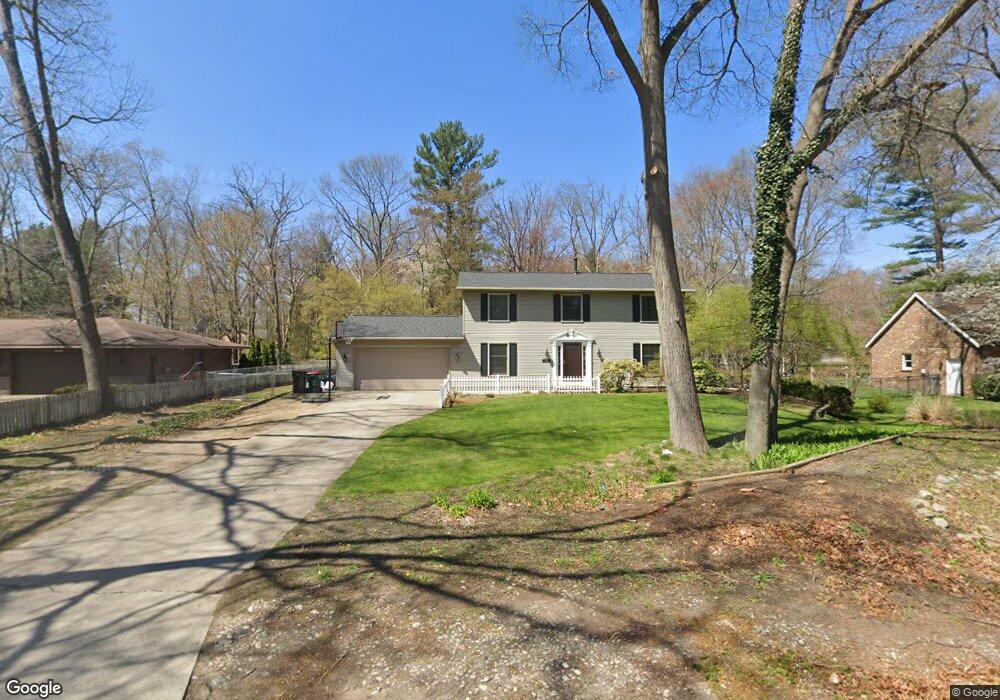
4619 Rood Rd Norton Shores, MI 49441
Estimated Value: $381,323 - $427,000
4
Beds
3
Baths
1,956
Sq Ft
$208/Sq Ft
Est. Value
About This Home
This home is located at 4619 Rood Rd, Norton Shores, MI 49441 and is currently estimated at $406,081, approximately $207 per square foot. 4619 Rood Rd is a home located in Muskegon County with nearby schools including Mona Shores High School, Michigan Dunes Montessori School, and West Shore Lutheran School.
Ownership History
Date
Name
Owned For
Owner Type
Purchase Details
Closed on
May 14, 2021
Sold by
Howell Jack J and Howell Chantel A
Bought by
Barangan Jayson C and Barangan Jennifer L
Current Estimated Value
Home Financials for this Owner
Home Financials are based on the most recent Mortgage that was taken out on this home.
Original Mortgage
$227,920
Outstanding Balance
$206,552
Interest Rate
3.1%
Mortgage Type
New Conventional
Estimated Equity
$199,529
Create a Home Valuation Report for This Property
The Home Valuation Report is an in-depth analysis detailing your home's value as well as a comparison with similar homes in the area
Home Values in the Area
Average Home Value in this Area
Purchase History
| Date | Buyer | Sale Price | Title Company |
|---|---|---|---|
| Barangan Jayson C | $284,900 | Ata National Title Group Llc |
Source: Public Records
Mortgage History
| Date | Status | Borrower | Loan Amount |
|---|---|---|---|
| Open | Barangan Jayson C | $227,920 |
Source: Public Records
Tax History Compared to Growth
Tax History
| Year | Tax Paid | Tax Assessment Tax Assessment Total Assessment is a certain percentage of the fair market value that is determined by local assessors to be the total taxable value of land and additions on the property. | Land | Improvement |
|---|---|---|---|---|
| 2025 | $4,541 | $145,400 | $0 | $0 |
| 2024 | $3,560 | $136,700 | $0 | $0 |
| 2023 | $3,400 | $118,200 | $0 | $0 |
| 2022 | $4,144 | $103,400 | $0 | $0 |
| 2021 | $2,774 | $94,800 | $0 | $0 |
| 2020 | $2,742 | $88,700 | $0 | $0 |
| 2019 | $2,692 | $79,200 | $0 | $0 |
| 2018 | $2,629 | $78,500 | $0 | $0 |
| 2017 | $2,568 | $75,900 | $0 | $0 |
| 2016 | $1,989 | $70,700 | $0 | $0 |
| 2015 | -- | $67,700 | $0 | $0 |
| 2014 | $2,386 | $65,500 | $0 | $0 |
| 2013 | -- | $61,900 | $0 | $0 |
Source: Public Records
Map
Nearby Homes
- 1559 Brookwood Dr
- 1345 Hendrick Rd
- 5116 Gay St
- 896 W Hile Rd
- 885 Eugene Ave
- 4000 Braeburn Dr
- 4655 Henry St
- 5230 Wickham Dr
- 5043 Maranatha Dr
- 873 Hendrick Rd
- 5128 Henry St
- 1020 Brookway Ct
- 951 Katie Ct Unit 32
- 1905 Crestwood Ln
- 1901 Maryland Blvd
- 2097 Geneva Ln
- 931 Ashlee Ct
- 4161 Dunes Pkwy
- 1243 Crandall Ave
- 3670 Henry St
- 4597 Rood Rd
- 4635 Rood Rd
- 4651 Rood Rd
- 1385 W Hile Rd
- 4630 Rood Rd
- 1384 W Hile Rd
- 1439 Rood Point Rd
- 1440 Brookwood Dr
- 4650 Rood Rd
- 1369 W Hile Rd
- 1370 W Hile Rd
- 1462 Brookwood Dr
- 1385 Rood Point Rd
- 1463 Rood Point Rd
- 1416 Brookwood Dr
- 1354 W Hile Rd
- 1355 W Hile Rd
- 1486 Brookwood Dr
- 1390 Brookwood Dr
- 1371 Rood Point Rd