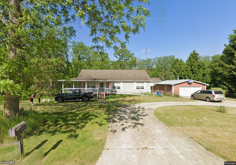
462 Babcock Rd Bronson, MI 49028
Estimated Value: $267,565 - $356,000
3
Beds
2
Baths
1,500
Sq Ft
$208/Sq Ft
Est. Value
About This Home
This home is located at 462 Babcock Rd, Bronson, MI 49028 and is currently estimated at $311,783, approximately $207 per square foot. 462 Babcock Rd is a home located in Branch County with nearby schools including Anderson Elementary School, Ryan Elementary School, and Bronson Junior/Senior High School.
Ownership History
Date
Name
Owned For
Owner Type
Purchase Details
Closed on
Sep 19, 2023
Sold by
Heitger Richard and Heitger Cheryl
Bought by
Thrush Justin
Current Estimated Value
Home Financials for this Owner
Home Financials are based on the most recent Mortgage that was taken out on this home.
Original Mortgage
$130,000
Outstanding Balance
$127,243
Interest Rate
6.96%
Mortgage Type
New Conventional
Estimated Equity
$184,540
Purchase Details
Closed on
Jun 4, 2007
Sold by
Thorn Hayes Ii Inc
Bought by
Heitger Richard and Heitger Cheryl
Create a Home Valuation Report for This Property
The Home Valuation Report is an in-depth analysis detailing your home's value as well as a comparison with similar homes in the area
Home Values in the Area
Average Home Value in this Area
Purchase History
| Date | Buyer | Sale Price | Title Company |
|---|---|---|---|
| Thrush Justin | $140,000 | None Listed On Document | |
| Heitger Richard | $29,000 | None Available |
Source: Public Records
Mortgage History
| Date | Status | Borrower | Loan Amount |
|---|---|---|---|
| Open | Thrush Justin | $130,000 |
Source: Public Records
Tax History Compared to Growth
Tax History
| Year | Tax Paid | Tax Assessment Tax Assessment Total Assessment is a certain percentage of the fair market value that is determined by local assessors to be the total taxable value of land and additions on the property. | Land | Improvement |
|---|---|---|---|---|
| 2025 | $2,548 | $148,900 | $0 | $0 |
| 2024 | $921 | $151,200 | $0 | $0 |
| 2023 | $921 | $145,500 | $0 | $0 |
| 2022 | $921 | $146,100 | $0 | $0 |
| 2021 | -- | $140,400 | $0 | $0 |
| 2020 | -- | $118,900 | $0 | $0 |
| 2019 | -- | $102,500 | $0 | $0 |
| 2018 | -- | $95,400 | $0 | $0 |
| 2017 | -- | $101,100 | $0 | $0 |
| 2016 | -- | $104,349 | $0 | $0 |
| 2015 | -- | $75,505 | $0 | $0 |
| 2014 | -- | $74,194 | $0 | $0 |
| 2013 | -- | $74,345 | $0 | $0 |
Source: Public Records
Map
Nearby Homes
- 786 W Colon Rd
- 912 W Colon Rd
- 555 Claar Rd
- 130 Osborn Rd
- 140 W Clay St
- 0 Dunks Rd
- 317 W Colon Rd
- 839 Adolph Rd
- 609 E Railroad St
- 325 N Lincoln St
- 322 W Chicago Rd
- 337 N Walker St
- 313 N Matteson St
- 150 Washington St
- 695 W Chicago Rd
- 410 Franklin St
- 147 Winona St
- 544 E Chicago St
- 881 Brent Dr
- 316 Kane Rd
- 469 Babcock Rd
- 479 Babcock Rd
- 486 Babcock Rd
- 492 Babcock Rd
- 799 Langwell Rd
- 1 Langwell Rd
- 0 Langwell Rd
- 0 Langwell Rd
- 421 Babcock Rd
- 805 Langwell Rd
- 422 Babcock Rd
- 824 Langwell Rd
- 403 Babcock Rd
- 404 Babcock Rd
- 794 W Colon Rd
- 762 W Colon Rd
- 776 W Colon Rd
- 766 W Colon Rd
- 766 W Colon Rd
- 835 Langwell Rd