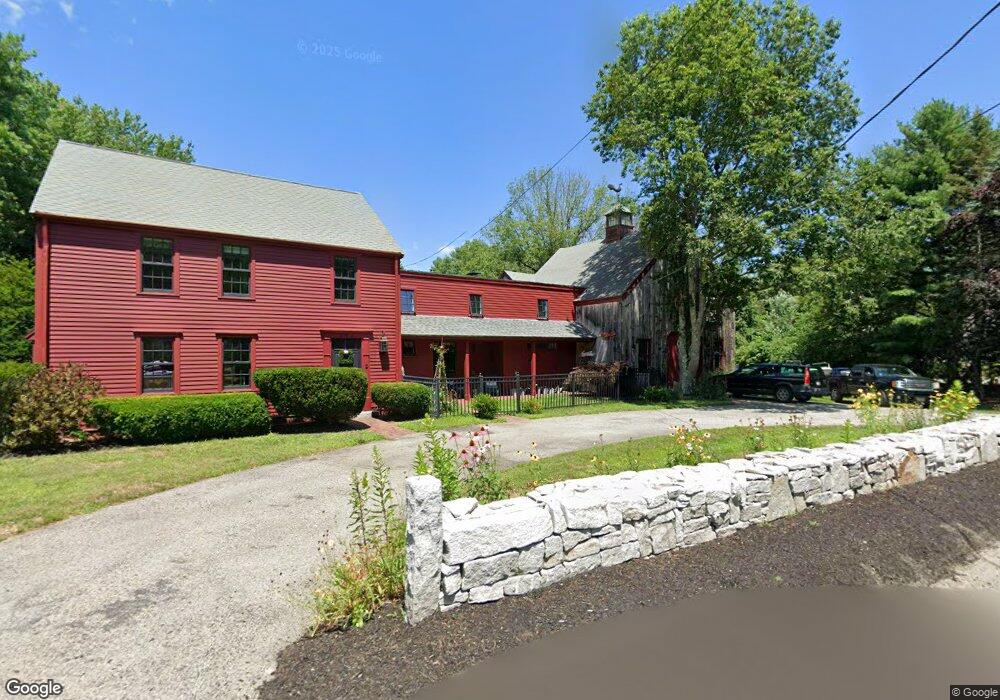
462 West St Duxbury, MA 02332
Estimated Value: $914,000 - $1,076,000
3
Beds
2
Baths
1,917
Sq Ft
$525/Sq Ft
Est. Value
About This Home
This home is located at 462 West St, Duxbury, MA 02332 and is currently estimated at $1,006,030, approximately $524 per square foot. 462 West St is a home located in Plymouth County with nearby schools including Chandler Elementary School, Alden School, and Duxbury Middle School.
Ownership History
Date
Name
Owned For
Owner Type
Purchase Details
Closed on
Sep 27, 1996
Sold by
Doyle Loretta A and Doyle Jamesp
Bought by
Thompson Scott and Downing-Thompson Betsy
Current Estimated Value
Purchase Details
Closed on
Apr 1, 1992
Sold by
Federal Home Loan Mortgage Corporation
Bought by
Doyle James P
Purchase Details
Closed on
Mar 31, 1992
Sold by
Johnston John E
Bought by
Comfed Sb Fa
Create a Home Valuation Report for This Property
The Home Valuation Report is an in-depth analysis detailing your home's value as well as a comparison with similar homes in the area
Home Values in the Area
Average Home Value in this Area
Purchase History
| Date | Buyer | Sale Price | Title Company |
|---|---|---|---|
| Thompson Scott | $224,000 | -- | |
| Thompson Scott | $224,000 | -- | |
| Doyle James P | $115,000 | -- | |
| Comfed Sb Fa | $155,964 | -- |
Source: Public Records
Mortgage History
| Date | Status | Borrower | Loan Amount |
|---|---|---|---|
| Open | Comfed Sb Fa | $294,000 | |
| Closed | Comfed Sb Fa | $300,000 |
Source: Public Records
Tax History Compared to Growth
Tax History
| Year | Tax Paid | Tax Assessment Tax Assessment Total Assessment is a certain percentage of the fair market value that is determined by local assessors to be the total taxable value of land and additions on the property. | Land | Improvement |
|---|---|---|---|---|
| 2025 | $7,888 | $777,900 | $494,100 | $283,800 |
| 2024 | $7,564 | $751,900 | $472,200 | $279,700 |
| 2023 | $7,660 | $716,600 | $506,800 | $209,800 |
| 2022 | $6,692 | $521,200 | $322,000 | $199,200 |
| 2021 | $7,162 | $494,600 | $311,300 | $183,300 |
| 2020 | $6,909 | $471,300 | $282,200 | $189,100 |
| 2019 | $6,713 | $457,300 | $262,100 | $195,200 |
| 2018 | $6,590 | $434,700 | $247,600 | $187,100 |
| 2017 | $6,817 | $439,500 | $247,600 | $191,900 |
| 2016 | $6,671 | $429,000 | $237,100 | $191,900 |
| 2015 | $6,139 | $393,500 | $201,600 | $191,900 |
Source: Public Records
Map
Nearby Homes
- 62 Teakettle Ln
- 33 Herring Weir Rd
- 225 Lincoln St Unit A3
- 16 Fieldstone Farm Way
- 15 Fieldstone Farm Way Unit 8
- 9 S Pasture Ln
- 15 Lady Slipper Ln
- 1141 Tremont St
- 184 King Phillips Pathe
- 676 Franklin St
- 431 Moraine St
- Two Railroad Ave Unit 9
- Two Railroad Ave Unit 1
- Two Railroad Ave Unit 8
- Two Railroad Ave Unit 2
- 10 Hawthorn Hill
- The Duplex Plan at The Village at Harlow Brook
- The Chatham Plan at The Village at Harlow Brook
- The Falmouth Plan at The Village at Harlow Brook
- 3 Harlow Brook Way Unit 3