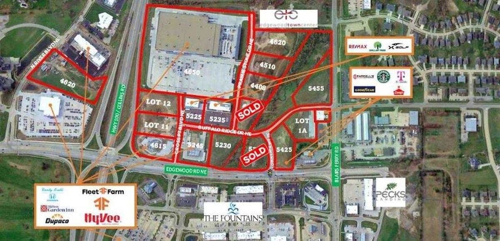
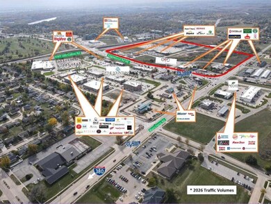
4620 N River Blvd NE Cedar Rapids, IA 52411
Estimated payment $9,619/month
About This Lot
This home is located at 4620 N River Blvd NE, Cedar Rapids, IA 52411 and is currently priced at $1,871,338. 4620 N River Blvd NE is a home located in Linn County with nearby schools including Viola Gibson Elementary School, Harding Middle School, and John F. Kennedy High School.
Property Details
Property Type
- Land
Lot Details
- 4.8 Acre Lot
- Level Lot
Community Details
- River Ridge Square Subdivision
Listing and Financial Details
- Assessor Parcel Number 1406-426006-00000
Map
Tax History
| Year | Tax Paid | Tax Assessment Tax Assessment Total Assessment is a certain percentage of the fair market value that is determined by local assessors to be the total taxable value of land and additions on the property. | Land | Improvement |
|---|---|---|---|---|
| 2025 | $96 | $6,300 | $6,300 | -- |
| 2024 | $102 | -- | -- | -- |
| 2023 | $102 | $5,400 | $5,400 | $0 |
| 2022 | $98 | $4,400 | $4,400 | $0 |
| 2021 | $90 | $4,400 | $4,400 | $0 |
| 2020 | $90 | $4,100 | $4,100 | $0 |
| 2019 | $0 | $0 | $0 | $0 |
Property History
| Date | Event | Price | List to Sale | Price per Sq Ft |
|---|---|---|---|---|
| 07/28/2021 07/28/21 | Price Changed | $1,871,338 | -99.0% | -- |
| 07/23/2021 07/23/21 | For Sale | $187,133,000 | -- | -- |
Source: Iowa City Area Association of REALTORS®
MLS Number: 202104271
APN: 14064-26006-00000
Disclaimer: Certain information contained herein is derived from information provided by parties other than Homes.com. All information provided is deemed reliable, but is not guaranteed to be accurate and should be independently verified.
![]() IDX information is provided exclusively for consumers’ personal, non-commercial use, that it may not be used for any purpose other than to identify prospective properties consumers may be interested in purchasing.
IDX information is provided exclusively for consumers’ personal, non-commercial use, that it may not be used for any purpose other than to identify prospective properties consumers may be interested in purchasing.
Listing information is deemed reliable, but not guaranteed accurate by the MLS.
- Lot 11 Cross Pointe Blvd NE
- Lot 12 Cross Pointe Blvd NE
- 4620 Prairie Stone Dr NE
- 4408 Prairie Stone Dr NE
- 4510 Prairie Stone Dr NE
- 5180 Chestnut Valley Rd
- 5230 Edgewood Rd NE
- Lot 1A Buffalo Ridge Dr NE
- 344 Worthington Ct
- 4105 N Willowbend Rd NE
- 5020 Erin Ct NE
- 5005 Willowbend Rd NE
- 4362 Cloverdale Rd
- 4019 Lexington Dr NE Unit D
- 4113 Lexington Ct NE Unit C
- 4602 Twin Pine Dr NE
- 4609 Pineview Dr NE
- 6001 Ridgewood Meadows Ln NE
- 3801 Foxborough Terrace NE Unit C
- 4020 Blue Jay Dr NE
- 1400 Blairs Ferry Rd
- 2200 Buckingham Dr NW
- 2415 River Bluff Dr NW
- 2113 N Towne Ct NE
- 2202-2238 River Bluffs Dr
- 100 Oak St
- 102 Oak St Unit 4
- 102 Oak St Unit 1
- 100 Boyson Rd
- 125 E Boyson Rd
- 1310-1320 Wenig Rd NE
- 4025 Sherman St NE
- 1621 Pinehurst Dr NE
- 1220 Sierra Dr NE
- 1230 Murray St NE Unit 5
- 1230 Murray St NE Unit 3
- 6025 Ridgemont Dr NE
- 1270 Edgewood Rd NW
- 921 Old Marion Rd NE
- 6214 Rockwell Dr NE

Ask me questions while you tour the home.