


46255 Highway 242 Myrtle Point, OR 97458
Estimated payment $2,962/month
Highlights
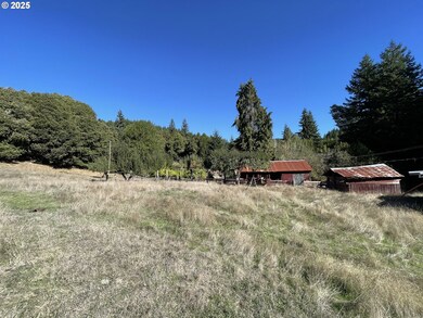
- Barn
- RV Access or Parking
- Covered Deck
- Home fronts a creek
- 10.88 Acre Lot
- Orchard
About This Home
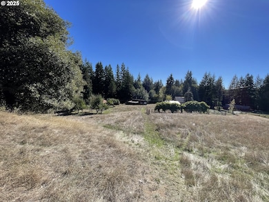
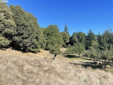
This 10.88-acre property offers a peaceful rural setting with a mix of open space, mature trees, and agricultural potential. The home was built in 1907 and sits in a quiet, scenic location just 8 miles from Powers on Highway 242.The land features an established apple orchard, grapevines, a year-round creek, and plenty of space for gardening. The property is fully fenced and includes two barns—one large and one small—ideal for livestock, equipment, or storage. A deer stand is also in place, offering opportunities for hunting or wildlife viewing.This is a versatile property well-suited for a hobby farm, homestead, or anyone looking to enjoy the country lifestyle.

Home Details
Home Type
- Single Family
Est. Annual Taxes
- $811
Year Built
- Built in 1907
Lot Details
- 10.88 Acre Lot
- Home fronts a creek
- Creek or Stream
- Fenced
- Secluded Lot
- Corner Lot
- Orchard
- Landscaped with Trees
- Private Yard
- Property is zoned RR-5
Home Design
- Victorian Architecture
- Metal Roof
Interior Spaces
- 952 Sq Ft Home
- 2-Story Property
- Gas Fireplace
- Propane Fireplace
- Family Room
- Living Room
- Dining Room
- Crawl Space
Kitchen
- Built-In Oven
- Stove
- Free-Standing Range
Bedrooms and Bathrooms
- 2 Bedrooms
- 1 Full Bathroom
Parking
- Carport
- Driveway
- RV Access or Parking
Accessible Home Design
- Handicap Accessible
- Accessibility Features
- Accessible Doors
- Accessible Approach with Ramp
- Accessible Entrance
- Accessible Parking
Outdoor Features
- Covered Deck
- Shed
- Porch
Schools
- Powers Elementary And Middle School
- Powers High School
Farming
- Barn
Utilities
- No Cooling
- No Heating
- Spring water is a source of water for the property
- Water Heater
- Septic Tank
Community Details
- No Home Owners Association
Listing and Financial Details
- Assessor Parcel Number 1311800
Map
Home Values in the Area
Average Home Value in this Area
Tax History
| Year | Tax Paid | Tax Assessment Tax Assessment Total Assessment is a certain percentage of the fair market value that is determined by local assessors to be the total taxable value of land and additions on the property. | Land | Improvement |
|---|---|---|---|---|
| 2024 | $811 | $113,870 | -- | -- |
| 2023 | $762 | $110,560 | $0 | $0 |
| 2022 | $753 | $107,340 | $0 | $0 |
| 2021 | $736 | $104,220 | $0 | $0 |
| 2020 | $718 | $104,220 | $0 | $0 |
| 2019 | $681 | $98,250 | $0 | $0 |
| 2018 | $665 | $95,390 | $0 | $0 |
| 2017 | $651 | $92,620 | $0 | $0 |
| 2016 | $635 | $89,930 | $0 | $0 |
| 2015 | $601 | $87,320 | $0 | $0 |
| 2014 | $601 | $84,780 | $0 | $0 |
Property History
| Date | Event | Price | List to Sale | Price per Sq Ft |
|---|---|---|---|---|
| 10/30/2025 10/30/25 | Price Changed | $550,000 | -15.4% | $578 / Sq Ft |
| 10/15/2025 10/15/25 | For Sale | $650,000 | -- | $683 / Sq Ft |
Purchase History
| Date | Type | Sale Price | Title Company |
|---|---|---|---|
| Interfamily Deed Transfer | -- | None Available |
Source: Regional Multiple Listing Service (RMLS)
MLS Number: 759990879
APN: 1001311800
Disclaimer: Certain information contained herein is derived from information provided by parties other than Homes.com. All information provided is deemed reliable, but is not guaranteed to be accurate and should be independently verified.
![]() The content relating to real estate for sale on this web site comes in part from the IDX program of the RMLS™ of Portland, Oregon. Real estate listings held by brokerage firms other than Ten-X are marked with the RMLS™ logo, and detailed information about these properties includes the names of the listing brokers. Listing content is copyright © 2025 RMLS™, Portland, Oregon. Some properties which appear for sale on this web site may subsequently have sold or may no longer be available. All information provided is deemed reliable but is not guaranteed and should be independently verified.
The content relating to real estate for sale on this web site comes in part from the IDX program of the RMLS™ of Portland, Oregon. Real estate listings held by brokerage firms other than Ten-X are marked with the RMLS™ logo, and detailed information about these properties includes the names of the listing brokers. Listing content is copyright © 2025 RMLS™, Portland, Oregon. Some properties which appear for sale on this web site may subsequently have sold or may no longer be available. All information provided is deemed reliable but is not guaranteed and should be independently verified.
- 46393 Highway 242
- 46760 Highway 242
- 45275 Highway 242
- 1010 H Ave
- 110 E Birch St
- 889 H Ave
- 711 H Ave
- 130 E Date St
- 151 E Date St
- 815 E Ave
- 711 Ave H
- 631 2nd Ave
- 51014 Dement Creek Rd
- 510 Fir St
- 141 Poplar St
- 432 2nd Ave
- 380 3rd Ave
- 15779 Oregon 42
- 45651 Johnson Mountain Rd
- 0 Johnson Mt Rd Unit 600 168667991