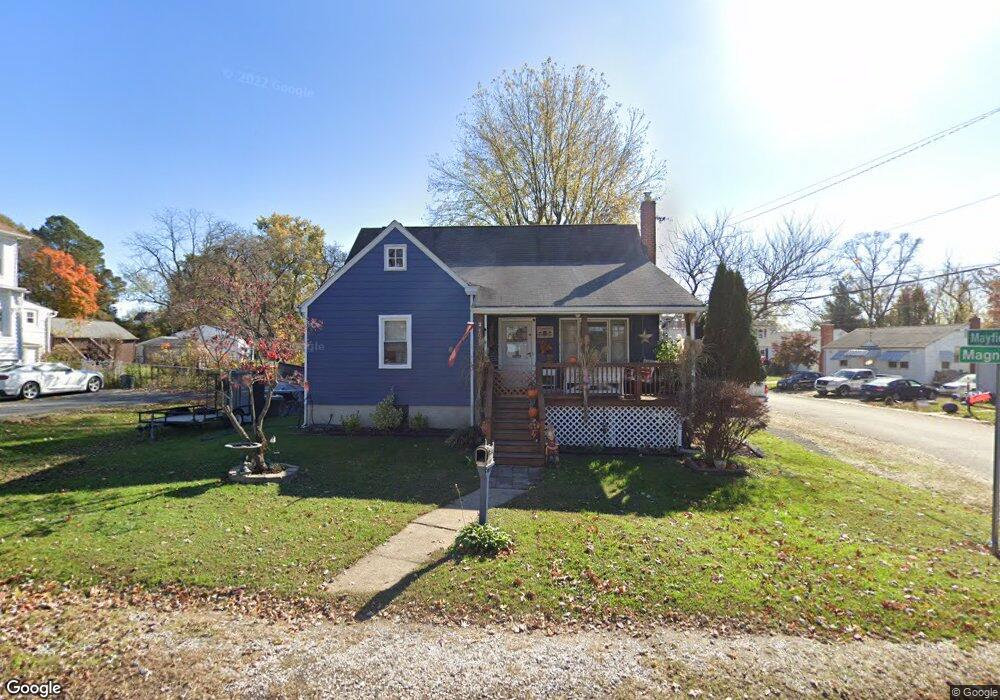
4629 Magnolia Ave Halethorpe, MD 21227
Estimated Value: $291,187 - $394,000
--
Bed
1
Bath
1,352
Sq Ft
$259/Sq Ft
Est. Value
About This Home
This home is located at 4629 Magnolia Ave, Halethorpe, MD 21227 and is currently estimated at $350,797, approximately $259 per square foot. 4629 Magnolia Ave is a home located in Baltimore County with nearby schools including Halethorpe Elementary School, Arbutus Middle School, and Lansdowne High School.
Ownership History
Date
Name
Owned For
Owner Type
Purchase Details
Closed on
Dec 23, 1994
Sold by
Oxendine Mildred C
Bought by
Thode Bert H
Current Estimated Value
Home Financials for this Owner
Home Financials are based on the most recent Mortgage that was taken out on this home.
Original Mortgage
$86,452
Interest Rate
9.19%
Purchase Details
Closed on
Dec 6, 1993
Sold by
Stilling
Bought by
Oxendine M C
Home Financials for this Owner
Home Financials are based on the most recent Mortgage that was taken out on this home.
Original Mortgage
$50,000
Interest Rate
6.69%
Create a Home Valuation Report for This Property
The Home Valuation Report is an in-depth analysis detailing your home's value as well as a comparison with similar homes in the area
Home Values in the Area
Average Home Value in this Area
Purchase History
| Date | Buyer | Sale Price | Title Company |
|---|---|---|---|
| Thode Bert H | $86,500 | -- | |
| Oxendine M C | $49,750 | -- |
Source: Public Records
Mortgage History
| Date | Status | Borrower | Loan Amount |
|---|---|---|---|
| Closed | Oxendine M C | $86,452 | |
| Previous Owner | Oxendine M C | $50,000 |
Source: Public Records
Tax History Compared to Growth
Tax History
| Year | Tax Paid | Tax Assessment Tax Assessment Total Assessment is a certain percentage of the fair market value that is determined by local assessors to be the total taxable value of land and additions on the property. | Land | Improvement |
|---|---|---|---|---|
| 2025 | $3,864 | $243,100 | -- | -- |
| 2024 | $3,864 | $228,000 | $69,600 | $158,400 |
| 2023 | $1,899 | $220,533 | $0 | $0 |
| 2022 | $3,580 | $213,067 | $0 | $0 |
| 2021 | $3,191 | $205,600 | $69,600 | $136,000 |
| 2020 | $3,191 | $201,867 | $0 | $0 |
| 2019 | $2,979 | $198,133 | $0 | $0 |
| 2018 | $2,828 | $194,400 | $69,600 | $124,800 |
| 2017 | $2,620 | $183,200 | $0 | $0 |
| 2016 | $2,150 | $172,000 | $0 | $0 |
| 2015 | $2,150 | $160,800 | $0 | $0 |
| 2014 | $2,150 | $160,800 | $0 | $0 |
Source: Public Records
Map
Nearby Homes
- 5742 1st Ave
- 1204 Oakland Ct
- 1810 Arbutus Ave
- 5701 1st Ave
- 4606 Ridge Ave
- 1816 Fairview Ave
- 1709 Woodside Ave
- 5627 Oakland Rd
- 1942 Catanna Ave
- 5605 Oregon Ave
- 2040 Northeast Ave
- 1173 Kelfield Dr
- 1246 Elm Rd
- 2019 Northeast Ave
- 6 Ingate Terrace
- 1243 Linden Ave
- 2014 Putnam Rd
- 5712 Richardson Mews Square
- 1130 Kelfield Dr
- 1132 Ingate Rd
- 4627 Magnolia Ave
- 1809 Mayfield Ave
- 1802 Mayfield Ave
- 1804 Mayfield Ave
- 1811 Mayfield Ave
- 4625 Magnolia Ave
- 4630 Magnolia Ave
- 1813 Mayfield Ave
- 4628 Magnolia Ave
- 1806 Mayfield Ave
- 4626 Magnolia Ave
- 4621 Magnolia Ave
- 1808 Mayfield Ave
- 1808 Winans Ave
- 1810 Mayfield Ave
- 4619 Magnolia Ave
- 1815 Mayfield Ave
- 1812 Mayfield Ave
- 4620 Magnolia Ave
- 1814 Mayfield Ave