Estimated Value: $386,541 - $452,000
3
Beds
1
Bath
1,083
Sq Ft
$385/Sq Ft
Est. Value
About This Home
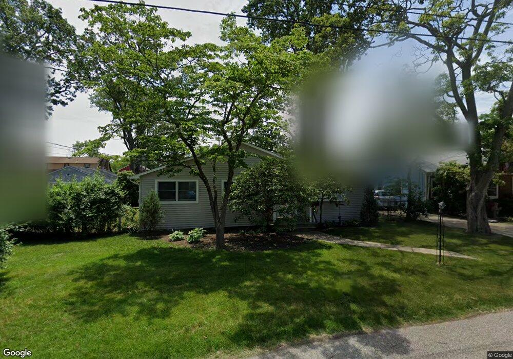
This home is located at 463 Burnt Bark Rd, Brick, NJ 08723 and is currently estimated at $416,885, approximately $384 per square foot. 463 Burnt Bark Rd is a home located in Ocean County with nearby schools including Emma Havens Young Elementary School, Lake Riviera Middle School, and Brick Township High School.
Ownership History
Date
Name
Owned For
Owner Type
Purchase Details
Closed on
May 11, 2012
Sold by
Berrett Tamara
Bought by
Hayes Sarah M
Current Estimated Value
Home Financials for this Owner
Home Financials are based on the most recent Mortgage that was taken out on this home.
Original Mortgage
$196,000
Outstanding Balance
$135,534
Interest Rate
4.01%
Mortgage Type
New Conventional
Estimated Equity
$281,351
Purchase Details
Closed on
Jul 10, 2008
Sold by
Ball Brian and Ball Ellen
Bought by
Ball Ellen
Home Financials for this Owner
Home Financials are based on the most recent Mortgage that was taken out on this home.
Original Mortgage
$125,000
Interest Rate
6.17%
Mortgage Type
New Conventional
Create a Home Valuation Report for This Property
The Home Valuation Report is an in-depth analysis detailing your home's value as well as a comparison with similar homes in the area
Home Values in the Area
Average Home Value in this Area
Purchase History
| Date | Buyer | Sale Price | Title Company |
|---|---|---|---|
| Hayes Sarah M | $245,000 | Counsellors Title Agency Inc | |
| Ball Ellen | -- | Old Republic National Title |
Source: Public Records
Mortgage History
| Date | Status | Borrower | Loan Amount |
|---|---|---|---|
| Open | Hayes Sarah M | $196,000 | |
| Previous Owner | Ball Ellen | $125,000 |
Source: Public Records
Tax History
| Year | Tax Paid | Tax Assessment Tax Assessment Total Assessment is a certain percentage of the fair market value that is determined by local assessors to be the total taxable value of land and additions on the property. | Land | Improvement |
|---|---|---|---|---|
| 2025 | $5,435 | $210,400 | $131,500 | $78,900 |
| 2024 | $5,165 | $210,400 | $131,500 | $78,900 |
| 2023 | $5,098 | $210,400 | $131,500 | $78,900 |
| 2022 | $5,098 | $210,400 | $131,500 | $78,900 |
| 2021 | $4,991 | $210,400 | $131,500 | $78,900 |
| 2020 | $4,928 | $210,400 | $131,500 | $78,900 |
| 2019 | $4,846 | $210,400 | $131,500 | $78,900 |
| 2018 | $4,734 | $210,400 | $131,500 | $78,900 |
| 2017 | $4,606 | $210,400 | $131,500 | $78,900 |
| 2016 | $4,583 | $210,400 | $131,500 | $78,900 |
| 2015 | $4,463 | $210,400 | $131,500 | $78,900 |
| 2014 | $4,427 | $210,400 | $131,500 | $78,900 |
Source: Public Records
Map
Nearby Homes
- 474 Burnt Bark Rd
- 478 Mantoloking Rd
- 477 Mantoloking Rd
- 0 Mantoloking Rd Unit 11584872
- 61 Reservation Row
- 53 Country Club Ct
- 56 Tall Timber Dr
- 15 Hulse Landing Rd
- 484 Bara St
- 00 Mantoloking Rd
- 439 Adamston Rd
- 507 Adamston Rd
- 9 Bayberry Ave
- 570 Mantoloking Rd
- 33 Wintergreen Ave
- 578 Kingfisher Cir
- 327 Mantoloking Rd
- 580 Kingfisher Cir
- 592 Kingfisher Cir
- 500 Princeton Ave
- 465 Burnt Bark Rd
- 459 Burnt Bark Rd
- 462 Pinecroft Dr
- 467 Burnt Bark Rd
- 458 Pinecroft Dr
- 462 Burnt Bark Rd
- 460 Burnt Bark Rd
- 464 Pinecroft Dr
- 464 Burnt Bark Rd
- 458 Burnt Bark Rd
- 469 Burnt Bark Rd
- 466 Burnt Bark Rd
- 26 Taylor Dr
- 22 Taylor Dr
- 30 Taylor Dr
- 468 Pinecroft Dr
- 22 Taylor Rd
- 471 Burnt Bark Rd
- 461 Augustus Rd
- 18 Taylor Dr
Your Personal Tour Guide
Ask me questions while you tour the home.