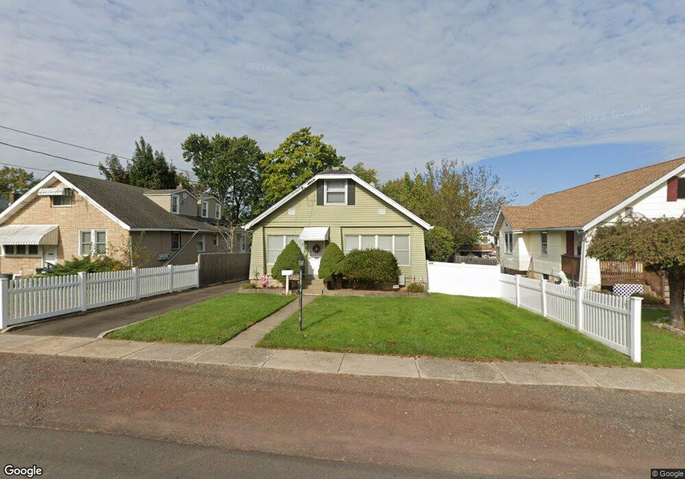
463 Springdale Ave Hatboro, PA 19040
Estimated Value: $337,000 - $408,379
3
Beds
2
Baths
1,472
Sq Ft
$251/Sq Ft
Est. Value
About This Home
This home is located at 463 Springdale Ave, Hatboro, PA 19040 and is currently estimated at $368,845, approximately $250 per square foot. 463 Springdale Ave is a home located in Montgomery County with nearby schools including Crooked Billet El School, Keith Valley Middle School, and Hatboro-Horsham High School.
Ownership History
Date
Name
Owned For
Owner Type
Purchase Details
Closed on
Nov 3, 2004
Sold by
Not Provided
Bought by
Not Provided
Current Estimated Value
Home Financials for this Owner
Home Financials are based on the most recent Mortgage that was taken out on this home.
Original Mortgage
$0
Interest Rate
5.71%
Purchase Details
Closed on
May 27, 1999
Sold by
Lee Debra L
Bought by
Grace Leonard M and Grace Lola
Create a Home Valuation Report for This Property
The Home Valuation Report is an in-depth analysis detailing your home's value as well as a comparison with similar homes in the area
Home Values in the Area
Average Home Value in this Area
Purchase History
| Date | Buyer | Sale Price | Title Company |
|---|---|---|---|
| Not Provided | $189,000 | -- | |
| Grace Leonard M | $120,000 | -- |
Source: Public Records
Mortgage History
| Date | Status | Borrower | Loan Amount |
|---|---|---|---|
| Closed | Not Provided | $0 | |
| Closed | Not Provided | $0 |
Source: Public Records
Tax History Compared to Growth
Tax History
| Year | Tax Paid | Tax Assessment Tax Assessment Total Assessment is a certain percentage of the fair market value that is determined by local assessors to be the total taxable value of land and additions on the property. | Land | Improvement |
|---|---|---|---|---|
| 2025 | $5,388 | $111,210 | $42,240 | $68,970 |
| 2024 | $5,388 | $111,210 | $42,240 | $68,970 |
| 2023 | $5,128 | $111,210 | $42,240 | $68,970 |
| 2022 | $4,994 | $111,210 | $42,240 | $68,970 |
| 2021 | $4,875 | $111,210 | $42,240 | $68,970 |
| 2020 | $4,732 | $111,210 | $42,240 | $68,970 |
| 2019 | $4,659 | $111,210 | $42,240 | $68,970 |
| 2018 | $4,658 | $111,210 | $42,240 | $68,970 |
| 2017 | $4,361 | $111,210 | $42,240 | $68,970 |
| 2016 | $4,318 | $111,210 | $42,240 | $68,970 |
| 2015 | $4,158 | $111,210 | $42,240 | $68,970 |
| 2014 | $4,158 | $111,210 | $42,240 | $68,970 |
Source: Public Records
Map
Nearby Homes
- 416 Preston Ln
- 513 Corinthian Ave
- 210 E Montgomery Ave
- 2900 E County Line Rd
- 102 Earl Ln
- 148 Byberry Rd
- 14 Norwyn Rd
- 205 Willard Rd
- 2710 E County Line Rd
- 194 Ann Ln
- 136 Washington Dr
- 165 W Moreland Ave
- 219 W Moreland Ave
- 45 Flamingo Rd
- 322 W Moreland Ave
- 425 Grape St
- 36 Jessop Ln
- 45 Fulmor Ave
- 220 Nemoral St
- 620 Constitutional Dr
- 459 Springdale Ave
- 465 Springdale Ave
- 467 Springdale Ave
- 455 Springdale Ave
- 451 Springdale Ave
- 466 Lincoln Ave
- 464 Lincoln Ave
- 460 Springdale Ave
- 470 Lincoln Ave
- 460 Lincoln Ave
- 475 Springdale Ave
- 462 Springdale Ave
- 452 Lincoln Ave
- 447 Springdale Ave
- 481 Springdale Ave
- 478 Lincoln Ave
- 458 Springdale Ave
- 452 Springdale Ave
- 450 Lincoln Ave
- 470 Springdale Ave