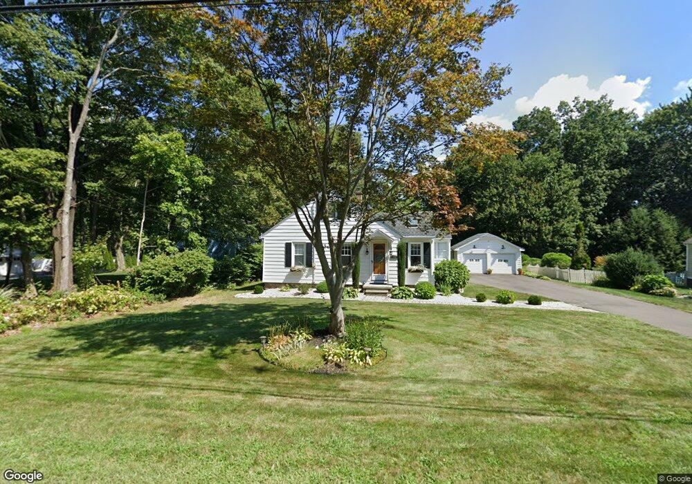
463 Todd Rd Wolcott, CT 06716
Estimated Value: $307,652 - $357,000
2
Beds
2
Baths
1,305
Sq Ft
$257/Sq Ft
Est. Value
About This Home
This home is located at 463 Todd Rd, Wolcott, CT 06716 and is currently estimated at $335,163, approximately $256 per square foot. 463 Todd Rd is a home located in New Haven County with nearby schools including Tyrrell Middle School and Wolcott High School.
Ownership History
Date
Name
Owned For
Owner Type
Purchase Details
Closed on
Jan 3, 2007
Sold by
Thornberg Daren E and Thornberg Frances M
Bought by
Prigonieri Lucinda
Current Estimated Value
Home Financials for this Owner
Home Financials are based on the most recent Mortgage that was taken out on this home.
Original Mortgage
$199,665
Outstanding Balance
$130,433
Interest Rate
7.95%
Estimated Equity
$204,730
Purchase Details
Closed on
Aug 1, 1990
Sold by
Mott Douglas H
Bought by
Thornberg Daren E
Create a Home Valuation Report for This Property
The Home Valuation Report is an in-depth analysis detailing your home's value as well as a comparison with similar homes in the area
Home Values in the Area
Average Home Value in this Area
Purchase History
| Date | Buyer | Sale Price | Title Company |
|---|---|---|---|
| Prigonieri Lucinda | $234,900 | -- | |
| Thornberg Daren E | $121,500 | -- |
Source: Public Records
Mortgage History
| Date | Status | Borrower | Loan Amount |
|---|---|---|---|
| Open | Thornberg Daren E | $199,665 | |
| Closed | Thornberg Daren E | $36,235 | |
| Closed | Thornberg Daren E | $94,000 | |
| Previous Owner | Thornberg Daren E | $90,000 |
Source: Public Records
Tax History
| Year | Tax Paid | Tax Assessment Tax Assessment Total Assessment is a certain percentage of the fair market value that is determined by local assessors to be the total taxable value of land and additions on the property. | Land | Improvement |
|---|---|---|---|---|
| 2025 | $5,279 | $146,920 | $36,490 | $110,430 |
| 2024 | $4,859 | $146,920 | $36,490 | $110,430 |
| 2023 | $4,682 | $146,920 | $36,490 | $110,430 |
| 2022 | $4,525 | $146,920 | $36,490 | $110,430 |
| 2021 | $4,106 | $123,900 | $34,600 | $89,300 |
| 2020 | $4,106 | $123,900 | $34,600 | $89,300 |
| 2019 | $4,106 | $123,900 | $34,600 | $89,300 |
| 2018 | $3,990 | $123,900 | $34,600 | $89,300 |
| 2017 | $3,874 | $123,900 | $34,600 | $89,300 |
| 2016 | $3,655 | $126,410 | $35,230 | $91,180 |
| 2015 | $3,550 | $126,410 | $35,230 | $91,180 |
| 2014 | $3,435 | $126,410 | $35,230 | $91,180 |
Source: Public Records
Map
Nearby Homes
- 443 Todd Rd
- Lot 167 Shelton Ave
- 1400 Meriden Rd Unit 5-2
- 30 Woodglen Dr Unit 7B2
- 380 Hitchcock Rd Unit 6
- 380 Hitchcock Rd Unit 198
- 312 Celia Dr
- 40 Leaf Ave
- 25 Norris St
- 41 Diane Terrace
- 7 Pratt Ln
- 45 Lake St
- 16 Crosswinds Ln
- 34 Nathan Hale Ct
- 23 Heaton St
- 27 Amber Place
- 24 Grove Ave
- 3280 E Main St
- 181 Decicco Rd
- 188 Beth Ln
Your Personal Tour Guide
Ask me questions while you tour the home.