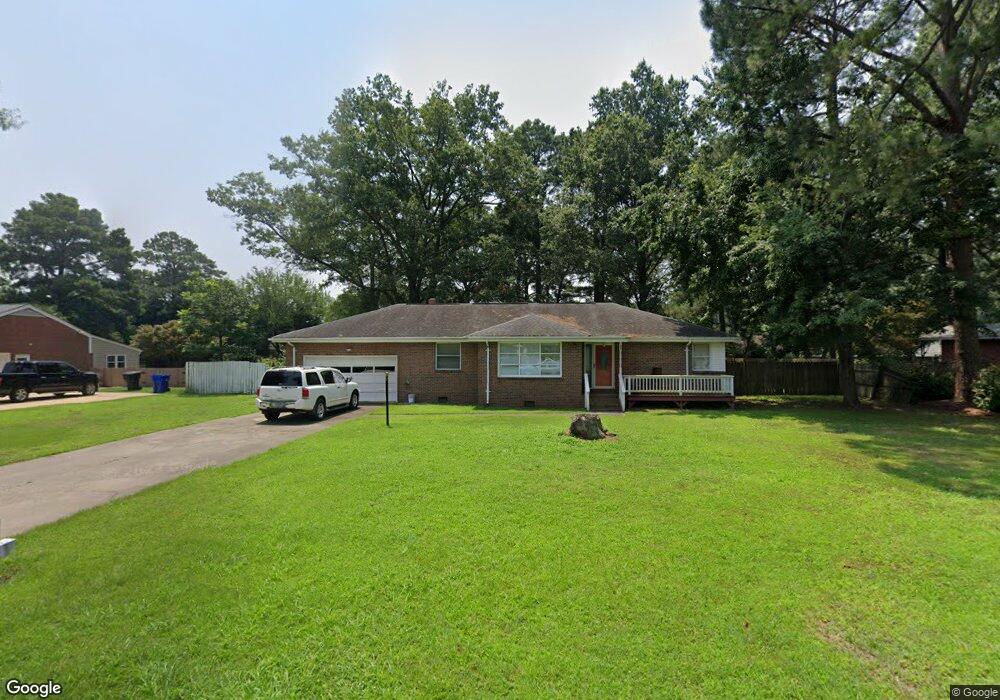
4638 River Shore Rd Portsmouth, VA 23703
Churchland NeighborhoodEstimated Value: $344,598 - $399,000
--
Bed
3
Baths
1,809
Sq Ft
$208/Sq Ft
Est. Value
About This Home
This home is located at 4638 River Shore Rd, Portsmouth, VA 23703 and is currently estimated at $375,650, approximately $207 per square foot. 4638 River Shore Rd is a home located in Portsmouth City with nearby schools including Churchland Primary/Intermediate School, Churchland Middle School, and Churchland High School.
Ownership History
Date
Name
Owned For
Owner Type
Purchase Details
Closed on
Apr 30, 2018
Sold by
Parker Robert M
Bought by
Allen-Santos Brandon and Allen-Santos Anette
Current Estimated Value
Home Financials for this Owner
Home Financials are based on the most recent Mortgage that was taken out on this home.
Original Mortgage
$175,000
Outstanding Balance
$150,532
Interest Rate
4.45%
Mortgage Type
Seller Take Back
Estimated Equity
$225,118
Create a Home Valuation Report for This Property
The Home Valuation Report is an in-depth analysis detailing your home's value as well as a comparison with similar homes in the area
Home Values in the Area
Average Home Value in this Area
Purchase History
| Date | Buyer | Sale Price | Title Company |
|---|---|---|---|
| Allen-Santos Brandon | $213,500 | Va Home Title & Settlements |
Source: Public Records
Mortgage History
| Date | Status | Borrower | Loan Amount |
|---|---|---|---|
| Open | Allen-Santos Brandon | $175,000 |
Source: Public Records
Tax History Compared to Growth
Tax History
| Year | Tax Paid | Tax Assessment Tax Assessment Total Assessment is a certain percentage of the fair market value that is determined by local assessors to be the total taxable value of land and additions on the property. | Land | Improvement |
|---|---|---|---|---|
| 2025 | $3,939 | $322,080 | $111,000 | $211,080 |
| 2024 | $3,939 | $320,230 | $111,000 | $209,230 |
| 2023 | $3,818 | $305,410 | $111,000 | $194,410 |
| 2022 | $3,898 | $299,870 | $92,500 | $207,370 |
| 2021 | $3,537 | $272,090 | $75,830 | $196,260 |
| 2020 | $3,490 | $268,480 | $72,220 | $196,260 |
| 2019 | $3,442 | $264,780 | $72,220 | $192,560 |
| 2018 | $3,346 | $257,380 | $72,220 | $185,160 |
| 2017 | $3,346 | $257,380 | $72,220 | $185,160 |
| 2016 | $3,346 | $257,380 | $72,220 | $185,160 |
| 2015 | $3,346 | $257,370 | $72,220 | $185,150 |
| 2014 | $3,263 | $256,930 | $72,220 | $184,710 |
Source: Public Records
Map
Nearby Homes
- 4619 River Shore Rd
- 4726 River Shore Rd
- 4444 Southampton Arch
- 21 Windy Pines Crescent
- 5833 Hawthorne Ln
- 5728 Hawthorne Ln
- 6750 Burbage Landing Cir
- 5693 Rivermill Cir
- 4224 Burnham Dr
- 4232 Summerset Dr
- 6602 James Point Ct
- 8 Compass Ct
- 5606 Gregory Ct
- 5028 Bay Cir
- 4200 Quince Rd
- 4071 Long Point Blvd
- 17 Shoal Ct
- 6832 Ivanhoe Ct
- 4100 Mayfair Way
- 4028 Swannanoa Dr
- 4634 River Shore Rd
- 4640 River Shore Rd
- 4625 Southampton Arch
- 4627 Southampton Arch
- 4623 Southampton Arch
- 4629 Southampton Arch
- 4639 River Shore Rd
- 4644 River Shore Rd
- 4630 River Shore Rd
- 4635 River Shore Rd
- 4643 River Shore Rd
- 4621 Southampton Arch
- 4631 River Shore Rd
- 4515 Twin Pines Rd
- 4624 Southampton Arch
- 4513 Twin Pines Rd
- 4626 Southampton Arch
- 4647 River Shore Rd
- 4622 Southampton Arch
- 4628 Southampton Arch