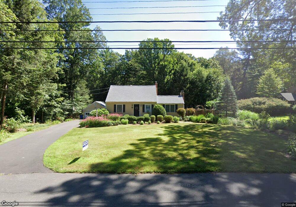
464 Firetown Rd Simsbury, CT 06070
Estimated Value: $406,000 - $498,000
4
Beds
3
Baths
1,549
Sq Ft
$296/Sq Ft
Est. Value
About This Home
This home is located at 464 Firetown Rd, Simsbury, CT 06070 and is currently estimated at $458,120, approximately $295 per square foot. 464 Firetown Rd is a home located in Hartford County with nearby schools including Squadron Line School, Henry James Memorial School, and Simsbury High School.
Ownership History
Date
Name
Owned For
Owner Type
Purchase Details
Closed on
Sep 10, 2018
Sold by
Murphy Thomas M and Murphy Gayle A
Bought by
Murphy Thomas M and Murphy Gayle A
Current Estimated Value
Purchase Details
Closed on
Jun 9, 1997
Sold by
New Haven Sb
Bought by
Follins Bernard B and Follins Angela R B
Purchase Details
Closed on
Apr 18, 1997
Sold by
Est Platt Albert and Platt Dennis
Bought by
Holcomb Gordon H
Create a Home Valuation Report for This Property
The Home Valuation Report is an in-depth analysis detailing your home's value as well as a comparison with similar homes in the area
Home Values in the Area
Average Home Value in this Area
Purchase History
| Date | Buyer | Sale Price | Title Company |
|---|---|---|---|
| Murphy Thomas M | -- | -- | |
| Follins Bernard B | $50,000 | -- | |
| Holcomb Gordon H | $117,500 | -- |
Source: Public Records
Mortgage History
| Date | Status | Borrower | Loan Amount |
|---|---|---|---|
| Previous Owner | Holcomb Gordon H | $180,000 | |
| Previous Owner | Holcomb Gordon H | $129,000 | |
| Previous Owner | Holcomb Gordon H | $138,500 |
Source: Public Records
Tax History
| Year | Tax Paid | Tax Assessment Tax Assessment Total Assessment is a certain percentage of the fair market value that is determined by local assessors to be the total taxable value of land and additions on the property. | Land | Improvement |
|---|---|---|---|---|
| 2025 | $6,863 | $200,900 | $62,370 | $138,530 |
| 2024 | $6,692 | $200,900 | $62,370 | $138,530 |
| 2023 | $6,306 | $198,170 | $62,370 | $135,800 |
| 2022 | $6,318 | $163,560 | $86,620 | $76,940 |
| 2021 | $6,318 | $163,560 | $86,620 | $76,940 |
| 2020 | $6,066 | $163,560 | $86,620 | $76,940 |
| 2019 | $6,104 | $163,560 | $86,620 | $76,940 |
| 2018 | $6,148 | $163,560 | $86,620 | $76,940 |
| 2017 | $5,877 | $151,630 | $84,410 | $67,220 |
| 2016 | $5,629 | $151,630 | $84,410 | $67,220 |
| 2015 | $5,629 | $151,630 | $84,410 | $67,220 |
| 2014 | $5,632 | $151,630 | $84,400 | $67,230 |
Source: Public Records
Map
Nearby Homes
- 324 Old Farms Rd
- 2 Lionel Dr
- 48 Whitman Dr
- 21 North Dr
- 84 Hop Brook Rd
- 68 Cambridge Ct
- 14 Brettonwood Dr
- 60 Barry Ln
- 87 Cambridge Ct
- 59 Cambridge Ct
- 62 Cambridge Ct
- 31 Oxford Ct
- 49 Carver Cir
- 9 1/2 E Tomstead Rd
- 32 Hemlock Rd
- 10 Massaco St Unit G
- 6 Heritage Ln
- 10 Pasture Ln
- 40 Firetown Rd Unit 22
- 86 Case St
- 462 Firetown Rd
- 468 Firetown Rd
- 17 Sanctuary Dr
- 463 Firetown Rd
- 459 Firetown Rd
- 458 Firetown Rd
- 472 Firetown Rd
- 15 Sanctuary Dr
- 2 Whitcomb Dr
- 453 Firetown Rd
- 6 Whitcomb Dr
- 19 Sanctuary Dr
- 4 Whitcomb Dr
- 476 Firetown Rd
- 471 Firetown Rd
- 455 Firetown Rd
- 22 Sanctuary Dr
- 11 Sanctuary Dr
- 8 Whitcomb Dr
- 20 Sanctuary Dr