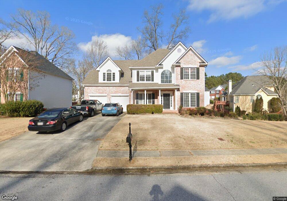
4645 Admiral Ridge Way SW Lilburn, GA 30047
Estimated Value: $432,000 - $508,000
3
Beds
3
Baths
2,374
Sq Ft
$198/Sq Ft
Est. Value
About This Home
This home is located at 4645 Admiral Ridge Way SW, Lilburn, GA 30047 and is currently estimated at $470,689, approximately $198 per square foot. 4645 Admiral Ridge Way SW is a home located in Gwinnett County with nearby schools including Camp Creek Elementary School, Trickum Middle School, and Parkview High School.
Ownership History
Date
Name
Owned For
Owner Type
Purchase Details
Closed on
Apr 28, 2000
Sold by
Richardson Housing Group Inc
Bought by
Tang Gangsheng
Current Estimated Value
Home Financials for this Owner
Home Financials are based on the most recent Mortgage that was taken out on this home.
Original Mortgage
$165,000
Outstanding Balance
$52,738
Interest Rate
7.5%
Mortgage Type
New Conventional
Estimated Equity
$417,951
Create a Home Valuation Report for This Property
The Home Valuation Report is an in-depth analysis detailing your home's value as well as a comparison with similar homes in the area
Home Values in the Area
Average Home Value in this Area
Purchase History
| Date | Buyer | Sale Price | Title Company |
|---|---|---|---|
| Tang Gangsheng | $209,000 | -- |
Source: Public Records
Mortgage History
| Date | Status | Borrower | Loan Amount |
|---|---|---|---|
| Open | Tang Gangsheng | $165,000 |
Source: Public Records
Tax History Compared to Growth
Tax History
| Year | Tax Paid | Tax Assessment Tax Assessment Total Assessment is a certain percentage of the fair market value that is determined by local assessors to be the total taxable value of land and additions on the property. | Land | Improvement |
|---|---|---|---|---|
| 2025 | -- | $182,400 | $30,000 | $152,400 |
| 2024 | -- | $172,520 | $30,000 | $142,520 |
| 2023 | $4,310 | $172,720 | $36,000 | $136,720 |
| 2022 | $4,480 | $158,880 | $30,800 | $128,080 |
| 2021 | $3,698 | $115,640 | $23,360 | $92,280 |
| 2020 | $3,724 | $115,640 | $23,360 | $92,280 |
| 2019 | $3,626 | $115,640 | $23,360 | $92,280 |
| 2018 | $3,439 | $106,800 | $20,000 | $86,800 |
| 2016 | $3,121 | $91,120 | $17,600 | $73,520 |
| 2015 | $3,050 | $86,840 | $16,000 | $70,840 |
| 2014 | -- | $84,720 | $16,000 | $68,720 |
Source: Public Records
Map
Nearby Homes
- 1296 Mandalay Ct SW
- 1178 Carla Joe Dr SW
- 1017 Rolling Forest Ln
- 1296 Lake Lucerne Rd SW
- 1226 Hickory Dr SW
- 1276 Hickory Dr SW
- 4327 Saint Michaels Dr SW
- 4449 Amberleaf Walk
- 4662 Ridgeland Dr SW
- 4672 Ridgeland Dr SW
- 4671 Ridgeland Dr SW
- 1337 Arlene Ct SW
- 1093 Hasty Ct SW
- 4271 Weston Dr SW
- 4702 Sequoia Dr SW
- 4367 Cedar Wood Dr SW
- 954 Camp Creek Dr SW
- 1348 Ridgewood Dr SW
- 4665 Admiral Ridge Way SW
- 1052 Bay Pointe Way SW
- 1042 Bay Pointe Way SW
- 4675 Admiral Ridge Way SW
- 4650 Admiral Ridge Way SW
- 1032 Bay Pointe Way SW
- 4640 Admiral Ridge Way SW
- 1062 Bay Pointe Way SW
- 4660 Admiral Ridge Way SW
- 4630 Admiral Ridge Way SW
- 1022 Bay Pointe Way SW
- 1022 Bay Pointe Way SW
- 1072 Bay Pointe Way SW
- 4685 Admiral Ridge Way SW
- 1012 Bay Pointe Way SW
- 4680 Admiral Ridge Way SW
- 4603 Hancock Way SW Unit 23
- 4603 Hancock Way SW
- 1002 Bay Pointe Way SW
- 1051 Bay Pointe Way SW