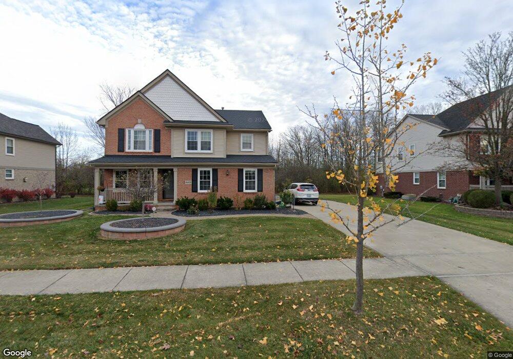
46457 Woodside Dr Unit 26 Canton, MI 48187
Estimated Value: $542,840 - $624,000
4
Beds
3
Baths
2,633
Sq Ft
$218/Sq Ft
Est. Value
About This Home
This home is located at 46457 Woodside Dr Unit 26, Canton, MI 48187 and is currently estimated at $573,210, approximately $217 per square foot. 46457 Woodside Dr Unit 26 is a home located in Wayne County with nearby schools including Canton High School, Discovery Middle School, and Plymouth High School.
Ownership History
Date
Name
Owned For
Owner Type
Purchase Details
Closed on
Mar 20, 2020
Sold by
Buchele Catherine M
Bought by
Connell Darin J O
Current Estimated Value
Purchase Details
Closed on
Oct 27, 2017
Sold by
Buchele Robert B
Bought by
Buchele Catherine M
Purchase Details
Closed on
Feb 28, 2007
Sold by
Habuda Blair A and Habuda Cynthia
Bought by
Buchele Robert B
Purchase Details
Closed on
Oct 29, 2002
Sold by
Centex Homes
Bought by
Habuda Blair A
Create a Home Valuation Report for This Property
The Home Valuation Report is an in-depth analysis detailing your home's value as well as a comparison with similar homes in the area
Home Values in the Area
Average Home Value in this Area
Purchase History
| Date | Buyer | Sale Price | Title Company |
|---|---|---|---|
| Connell Darin J O | $370,000 | Hometown One Title Agcy Llc | |
| Buchele Catherine M | -- | None Available | |
| Buchele Robert B | $289,500 | Multiple | |
| Habuda Blair A | -- | Lawyers Title Ins Corp |
Source: Public Records
Tax History
| Year | Tax Paid | Tax Assessment Tax Assessment Total Assessment is a certain percentage of the fair market value that is determined by local assessors to be the total taxable value of land and additions on the property. | Land | Improvement |
|---|---|---|---|---|
| 2025 | $202 | $237,200 | $0 | $0 |
| 2024 | $202 | $215,800 | $0 | $0 |
| 2023 | $166 | $0 | $0 | $0 |
| 2022 | $171 | $0 | $0 | $0 |
| 2021 | $166 | $0 | $0 | $0 |
| 2020 | $2,577 | $177,800 | $0 | $0 |
| 2019 | $5,421 | $174,550 | $0 | $0 |
| 2018 | $2,252 | $174,590 | $0 | $0 |
| 2017 | $5,488 | $174,700 | $0 | $0 |
| 2016 | $4,926 | $178,700 | $0 | $0 |
| 2015 | $12,374 | $160,720 | $0 | $0 |
| 2013 | $11,988 | $134,090 | $0 | $0 |
| 2010 | -- | $116,730 | $52,000 | $64,730 |
Source: Public Records
Map
Nearby Homes
- 45863 Baywood Blvd
- 1289 Old Colony Ln Unit 232
- 1244 W Crystal Cir
- 45900 S Stonewood Rd Unit 225
- 1276 W Crystal Cir Unit 202
- 1632 Peninsula Ct Unit 159
- 1725 Gorman St
- 45707 N Stonewood Rd
- 45874 S Stonewood Rd Unit 221
- 45679 N Stonewood Rd Unit 58
- 241 Country Club Ln
- 47450 Ellery Ln
- 1584 Commodore Cir Unit 33
- 215 Edington Cir
- 45005 Saltz Rd
- 0000 Ford
- 241 Edington Cir
- 45246 Gerald Ct
- 00000 Maben Rd
- 48030 Cherry Hill Rd
- 46439 Woodside Dr
- 46440 Woodside Dr Unit Bldg-Unit
- 46440 Woodside Dr
- 46495 Woodside Dr
- 46419 Woodside Dr
- 46496 Woodside Dr
- 46418 Woodside Dr Unit 23
- 46515 Woodside Dr
- 46552 Woodside Dr
- 46551 Brookridge Dr
- 46570 Woodside Dr
- 46331 Saltz Rd
- 46472 Brookridge Dr
- 46430 Brookridge Dr
- 46678 Woodside Dr
- 46475 Woodside Dr
- 46516 Brookridge Dr
- 46571 Woodside Dr
- 46573 Brookridge Dr Unit 10
- 747 Ashton Woods Dr Unit 8
Your Personal Tour Guide
Ask me questions while you tour the home.