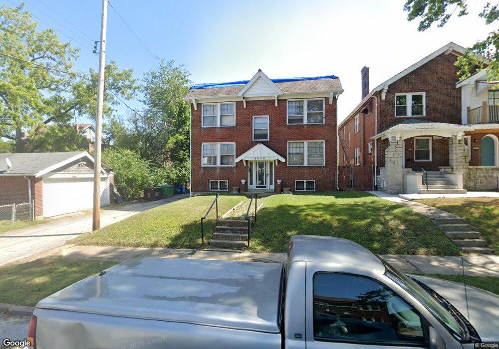
4646 Carrie Ave Saint Louis, MO 63115
Penrose NeighborhoodEstimated Value: $108,000 - $144,000
--
Bed
4
Baths
3,570
Sq Ft
$34/Sq Ft
Est. Value
About This Home
This home is located at 4646 Carrie Ave, Saint Louis, MO 63115 and is currently estimated at $122,000, approximately $34 per square foot. 4646 Carrie Ave is a home located in St. Louis City with nearby schools including Hickey Elementary School, Yeatman-Liddell Middle School, and Vashon High School.
Ownership History
Date
Name
Owned For
Owner Type
Purchase Details
Closed on
Apr 1, 2021
Sold by
Harrell Roland and Harrell Marcia
Bought by
Harrell Armentha J
Current Estimated Value
Purchase Details
Closed on
Nov 9, 2010
Sold by
Marciano Sharon
Bought by
Federal Home Loan Mortgage Corp
Create a Home Valuation Report for This Property
The Home Valuation Report is an in-depth analysis detailing your home's value as well as a comparison with similar homes in the area
Home Values in the Area
Average Home Value in this Area
Purchase History
| Date | Buyer | Sale Price | Title Company |
|---|---|---|---|
| Harrell Armentha J | -- | None Available | |
| Federal Home Loan Mortgage Corp | $118,113 | None Available |
Source: Public Records
Tax History Compared to Growth
Tax History
| Year | Tax Paid | Tax Assessment Tax Assessment Total Assessment is a certain percentage of the fair market value that is determined by local assessors to be the total taxable value of land and additions on the property. | Land | Improvement |
|---|---|---|---|---|
| 2025 | $329 | $3,720 | $650 | $3,070 |
| 2024 | $315 | $3,600 | $650 | $2,950 |
| 2023 | $315 | $3,600 | $650 | $2,950 |
| 2022 | $321 | $3,550 | $650 | $2,900 |
| 2021 | $321 | $3,550 | $650 | $2,900 |
| 2020 | $319 | $3,550 | $650 | $2,900 |
| 2019 | $318 | $3,560 | $650 | $2,910 |
| 2018 | $307 | $3,310 | $650 | $2,660 |
| 2017 | $302 | $3,310 | $650 | $2,660 |
| 2016 | $375 | $4,140 | $1,200 | $2,950 |
| 2015 | $342 | $4,150 | $1,200 | $2,950 |
| 2014 | $341 | $4,150 | $1,200 | $2,950 |
| 2013 | -- | $4,130 | $1,200 | $2,930 |
Source: Public Records
Map
Nearby Homes
- 4648 Pope Ave
- 4610 Pope Ave
- 4608 Pope Ave
- 4537 Clarence Ave
- 4535 Holly Ave
- 4454 Holly Ave
- 4450 Holly Ave
- 4419 Holly Ave
- 4402 Clarence Ave
- 4680 W Florissant Ave
- 4418 Dryden Ave
- 4627 Korte Ave
- 4449 Anderson Ave
- 4253 Holly Ave
- 4237 Holly Ave
- 4556 Carter Ave
- 4246 N Taylor Ave
- 4477 Bessie Ave
- 4210 E Carter Ave
- 4219 Red Bud Ave
- 4642 Carrie Ave
- 4640 Carrie Ave
- 4420 Floriss Place
- 4424 Floriss Place
- 4634 Carrie Ave
- 4416 Floriss Place
- 4418 Floriss Place
- 4428 Floriss Place
- 4630 Carrie Ave
- 4645 Pope Ave
- 4649 Pope Ave
- 4438 Floriss Place
- 4651 Pope Ave
- 4626 Carrie Ave
- 4635 Pope Ave
- 4408 Floriss Place
- 4647 Carrie Ave
- 44174419 Floriss Place
- 4643 Carrie Ave
- 4440 Floriss Place