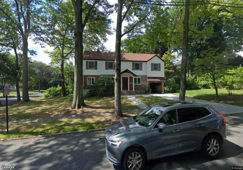
465 5th Ave River Edge, NJ 07661
Estimated Value: $853,613 - $982,000
Studio
--
Bath
2,080
Sq Ft
$436/Sq Ft
Est. Value
About This Home
This home is located at 465 5th Ave, River Edge, NJ 07661 and is currently estimated at $907,153, approximately $436 per square foot. 465 5th Ave is a home located in Bergen County with nearby schools including Cherry Hill School, River Dell Middle School, and River Dell Regional High School.
Ownership History
Date
Name
Owned For
Owner Type
Purchase Details
Closed on
Nov 5, 2007
Sold by
Garland Margaret An D and Gartland Aloysius J
Bought by
Gartland Margaret A D
Current Estimated Value
Purchase Details
Closed on
Nov 12, 1999
Sold by
Gartland Margaret Ann D
Bought by
Gartland Aloysius J
Purchase Details
Closed on
Apr 9, 1999
Sold by
Gartland Aloysius J
Bought by
Gartland Margaret Ann D
Create a Home Valuation Report for This Property
The Home Valuation Report is an in-depth analysis detailing your home's value as well as a comparison with similar homes in the area
Home Values in the Area
Average Home Value in this Area
Purchase History
| Date | Buyer | Sale Price | Title Company |
|---|---|---|---|
| Gartland Margaret A D | -- | -- | |
| Gartland Aloysius J | -- | -- | |
| Gartland Margaret Ann D | -- | -- |
Source: Public Records
Tax History
| Year | Tax Paid | Tax Assessment Tax Assessment Total Assessment is a certain percentage of the fair market value that is determined by local assessors to be the total taxable value of land and additions on the property. | Land | Improvement |
|---|---|---|---|---|
| 2025 | $16,268 | $631,000 | $342,600 | $288,400 |
| 2024 | $15,862 | $410,300 | $211,400 | $198,900 |
| 2023 | $15,181 | $410,300 | $211,400 | $198,900 |
| 2022 | $15,181 | $410,300 | $211,400 | $198,900 |
| 2021 | $14,882 | $410,300 | $211,400 | $198,900 |
| 2020 | $14,648 | $410,300 | $211,400 | $198,900 |
| 2019 | $14,229 | $410,300 | $211,400 | $198,900 |
| 2018 | $13,930 | $410,300 | $211,400 | $198,900 |
| 2017 | $13,794 | $410,300 | $211,400 | $198,900 |
| 2016 | $13,482 | $410,300 | $211,400 | $198,900 |
| 2015 | $13,199 | $410,300 | $211,400 | $198,900 |
| 2014 | $13,224 | $410,300 | $211,400 | $198,900 |
Source: Public Records
Map
Nearby Homes
- 405 Valley Rd
- 239 Greenway Terrace
- 374 Valley Rd
- 212 Monroe Ave
- 457 the Fenway
- 269 Adams Ave
- 189 Forest Ave Unit 117
- 189 Forest Ave Unit 409
- 302 Howland Ave
- 117 Monroe Ave
- 122 Village Cir E
- 127 Village Cir E
- 378 Windsor Rd
- 284 Continental Ave
- 409 Windsor Rd
- 81 Eastbrook Dr
- 300 Spring Valley Rd
- 12 Gainesborough Terrace Unit 1B
- 766 7th Ave
- 406 Kinderkamack Rd
- 284 Kensington Rd
- 475 5th Ave
- 288 Kensington Rd
- 464 5th Ave
- 283 Voorhis Ave
- 287 Voorhis Ave
- 474 5th Ave
- 292 Kensington Rd
- 283 Kensington Rd
- 270 Kensington Rd
- 287 Kensington Rd
- 291 Voorhis Ave
- 271 Voorhis Ave
- 452 5th Ave
- 291 Kensington Rd
- 266 Kensington Rd
- 269 Kensington Rd
- 267 Voorhis Ave
- 500 Manning Ct
- 485 5th Ave
Your Personal Tour Guide
Ask me questions while you tour the home.