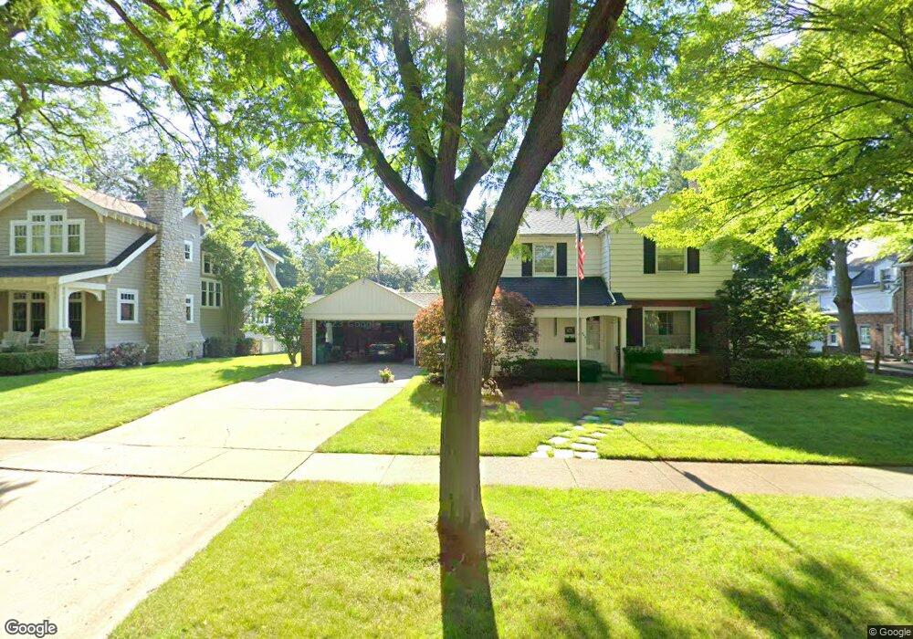
465 Berwyn St Birmingham, MI 48009
Estimated Value: $1,477,981 - $1,766,000
3
Beds
5
Baths
4,015
Sq Ft
$399/Sq Ft
Est. Value
About This Home
This home is located at 465 Berwyn St, Birmingham, MI 48009 and is currently estimated at $1,600,995, approximately $398 per square foot. 465 Berwyn St is a home located in Oakland County with nearby schools including Pierce Elementary School, Derby Middle School, and Ernest W. Seaholm High School.
Ownership History
Date
Name
Owned For
Owner Type
Purchase Details
Closed on
Jul 29, 2020
Sold by
Mistele Henry E and Wilfred L Whitfield Trust
Bought by
Beck Amy L and Beck William B
Current Estimated Value
Purchase Details
Closed on
Oct 7, 2019
Sold by
Whitfield Wilfred L and Whitfield Julia Knight
Bought by
Whitfield Wilfred L and Wilfred L Whitfield Trust
Create a Home Valuation Report for This Property
The Home Valuation Report is an in-depth analysis detailing your home's value as well as a comparison with similar homes in the area
Home Values in the Area
Average Home Value in this Area
Purchase History
| Date | Buyer | Sale Price | Title Company |
|---|---|---|---|
| Beck Amy L | $465,600 | Devon Title Agency | |
| Whitfield Wilfred L | -- | None Available |
Source: Public Records
Tax History Compared to Growth
Tax History
| Year | Tax Paid | Tax Assessment Tax Assessment Total Assessment is a certain percentage of the fair market value that is determined by local assessors to be the total taxable value of land and additions on the property. | Land | Improvement |
|---|---|---|---|---|
| 2024 | $15,325 | $630,290 | $0 | $0 |
| 2023 | $14,685 | $566,010 | $0 | $0 |
| 2022 | $9,716 | $268,750 | $0 | $0 |
| 2021 | $9,802 | $243,800 | $0 | $0 |
| 2020 | $7,351 | $274,840 | $0 | $0 |
| 2019 | $8,319 | $289,840 | $0 | $0 |
| 2018 | $8,255 | $272,930 | $0 | $0 |
| 2017 | $8,241 | $262,990 | $0 | $0 |
| 2016 | $8,256 | $256,730 | $0 | $0 |
| 2015 | -- | $238,070 | $0 | $0 |
| 2014 | -- | $215,830 | $0 | $0 |
| 2011 | -- | $187,920 | $0 | $0 |
Source: Public Records
Map
Nearby Homes
- 394 S Glenhurst Dr
- 397 S Cranbrook Rd
- 421 S Williamsbury Rd
- 695 Westchester Way
- 120 Westchester Way
- 786 S Cranbrook Rd
- 520 Pleasant St
- 2802 Heathfield Rd
- 2330 Fairway Dr
- 2721 Heathfield Rd
- 345 Kimberly St
- 1834 Fairview St
- 999 Pleasant Ave
- 1777 Fairway Dr
- 222 Arlington St
- 1882 Melbourne St
- 1570 Northlawn Blvd
- 2579 Amberly Rd
- 1057 Arlington St
- 100 Overhill Rd
- 447 Berwyn St
- 497 Berwyn St Unit Bldg-Unit
- 497 Berwyn St
- 490 Argyle St
- 0 Woodlea St Unit 213037977
- 0 Woodlea St Unit 213098978
- 0 Woodlea St
- 540 Argyle St Unit Bldg-Unit
- 540 Argyle St
- 425 Berwyn St
- 468 Argyle St
- 468 Berwyn St
- 444 Berwyn St
- 423 Berwyn St
- 543 Berwyn St
- 490 Berwyn St
- 574 Argyle St
- 395 Berwyn St
- 420 Berwyn St
- 426 Argyle St