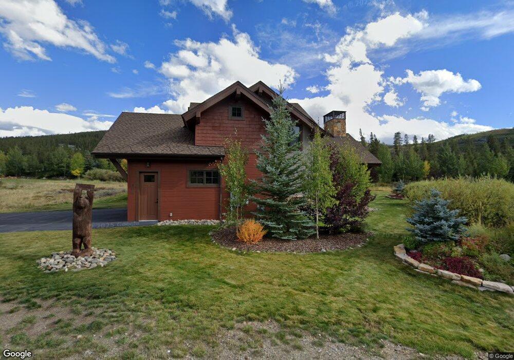
465 Davenoport Loop Breckenridge, CO 80424
Estimated Value: $2,444,000 - $3,189,000
3
Beds
2
Baths
2,405
Sq Ft
$1,133/Sq Ft
Est. Value
About This Home
This home is located at 465 Davenoport Loop, Breckenridge, CO 80424 and is currently estimated at $2,724,962, approximately $1,133 per square foot. 465 Davenoport Loop is a home with nearby schools including Upper Blue Elementary School, Summit Middle School, and Summit High School.
Ownership History
Date
Name
Owned For
Owner Type
Purchase Details
Closed on
Sep 22, 2015
Sold by
The Michael & Anne Reizer 1999 Managment
Bought by
Franklin Larry N and Mihalic Carol J
Current Estimated Value
Purchase Details
Closed on
Jun 25, 2008
Sold by
Holthaus James W and Holthaus Karen L
Bought by
The James W Holthaus Revocable Trust
Purchase Details
Closed on
Aug 24, 2007
Sold by
Ymir Holdings Lcc
Bought by
The Michael And Anne Reizer 1999 Managem
Purchase Details
Closed on
Oct 17, 2005
Sold by
Cox Arlo G
Bought by
Ymir Holdings Llc
Home Financials for this Owner
Home Financials are based on the most recent Mortgage that was taken out on this home.
Original Mortgage
$275,000
Interest Rate
5%
Mortgage Type
Seller Take Back
Create a Home Valuation Report for This Property
The Home Valuation Report is an in-depth analysis detailing your home's value as well as a comparison with similar homes in the area
Home Values in the Area
Average Home Value in this Area
Purchase History
| Date | Buyer | Sale Price | Title Company |
|---|---|---|---|
| Franklin Larry N | $310,000 | Title Company Of The Rockies | |
| The James W Holthaus Revocable Trust | -- | None Available | |
| The Michael And Anne Reizer 1999 Managem | $3,700,000 | None Available | |
| Ymir Holdings Llc | $275,000 | None Available |
Source: Public Records
Mortgage History
| Date | Status | Borrower | Loan Amount |
|---|---|---|---|
| Previous Owner | Ymir Holdings Llc | $275,000 |
Source: Public Records
Tax History Compared to Growth
Tax History
| Year | Tax Paid | Tax Assessment Tax Assessment Total Assessment is a certain percentage of the fair market value that is determined by local assessors to be the total taxable value of land and additions on the property. | Land | Improvement |
|---|---|---|---|---|
| 2024 | $7,903 | $164,345 | -- | -- |
| 2023 | $7,903 | $160,659 | $0 | $0 |
| 2022 | $5,387 | $102,485 | $0 | $0 |
| 2021 | $5,486 | $105,434 | $0 | $0 |
| 2020 | $4,892 | $93,246 | $0 | $0 |
| 2019 | $4,823 | $93,246 | $0 | $0 |
| 2018 | $3,742 | $70,090 | $0 | $0 |
| 2017 | $3,422 | $70,090 | $0 | $0 |
| 2016 | $2,624 | $52,929 | $0 | $0 |
| 2015 | $2,540 | $52,929 | $0 | $0 |
| 2014 | $2,235 | $45,950 | $0 | $0 |
| 2013 | -- | $45,950 | $0 | $0 |
Source: Public Records
Map
Nearby Homes
- 59 Gold Run Rd
- 228 Cottonwood Cir
- 220 Cottonwood Cir
- 1066 Estates Dr
- 294 Gold Run Rd
- 452 Hamilton Ct
- 550 Gold Run Rd
- 550 Gold Run Rd Unit 70
- 407 Lake Edge Dr
- 407 Lake Edge Dr Unit 90
- 705 Discovery Hill Dr
- 586 Discovery Hill Dr
- 792 Discovery Hill Dr
- TBD Tiger Rd
- 2383 Tiger Rd
- 3 Swan Dr
- 192 Upland Dr
- 19 South Rd
- 771 Fairways Dr
- 713 Fairways Dr
- 455 Davenoport Loop
- 435 Davenport Loop
- 445 Davenport Loop
- 397 Davenoport Loop
- 58 Galena Ct
- 402 Davenoport Loop
- 1691 Tiger Rd
- 28 Galena Ct
- 59 Galena Ct Unit B
- 59 Galena Ct
- 341 Davenport Loop
- 47 Galena Ct
- 332 Davenport Loop
- 1735 Tiger Rd
- 304 Estates Dr
- 18 Buffalo Trace
- 46 Buffalo Trace
- 1786 Tiger Rd
- 1781 Tiger Rd
- 239 Davenport Loop