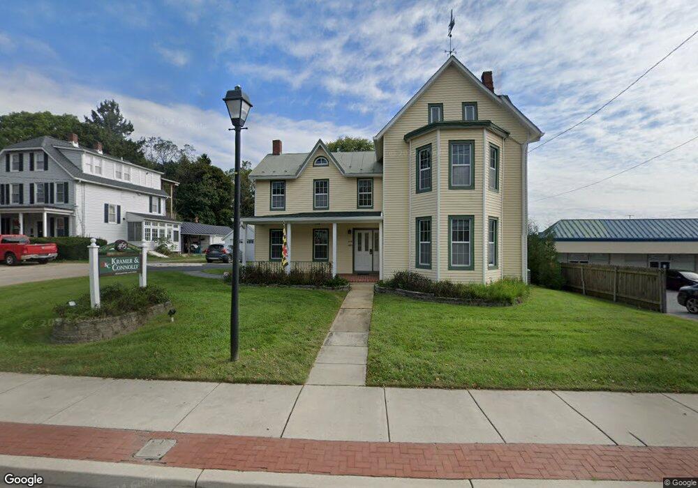
465 Main St Reisterstown, MD 21136
Estimated Value: $410,000 - $529,000
7
Beds
1
Bath
2,858
Sq Ft
$166/Sq Ft
Est. Value
About This Home
This home is located at 465 Main St, Reisterstown, MD 21136 and is currently estimated at $473,635, approximately $165 per square foot. 465 Main St is a home located in Baltimore County with nearby schools including Reisterstown Elementary, Franklin Middle, and Franklin High.
Ownership History
Date
Name
Owned For
Owner Type
Purchase Details
Closed on
Mar 4, 2021
Sold by
Ebaugh House Llc
Bought by
Kramer Irwin R
Current Estimated Value
Home Financials for this Owner
Home Financials are based on the most recent Mortgage that was taken out on this home.
Original Mortgage
$230,000
Interest Rate
2.9%
Mortgage Type
New Conventional
Purchase Details
Closed on
Jun 23, 2010
Sold by
Hammond Lloyd J
Bought by
Ebaugh House Llc
Create a Home Valuation Report for This Property
The Home Valuation Report is an in-depth analysis detailing your home's value as well as a comparison with similar homes in the area
Home Values in the Area
Average Home Value in this Area
Purchase History
| Date | Buyer | Sale Price | Title Company |
|---|---|---|---|
| Kramer Irwin R | -- | Certified Title Corp | |
| Ebaugh House Llc | $235,000 | -- |
Source: Public Records
Mortgage History
| Date | Status | Borrower | Loan Amount |
|---|---|---|---|
| Previous Owner | Kramer Irwin R | $230,000 |
Source: Public Records
Tax History Compared to Growth
Tax History
| Year | Tax Paid | Tax Assessment Tax Assessment Total Assessment is a certain percentage of the fair market value that is determined by local assessors to be the total taxable value of land and additions on the property. | Land | Improvement |
|---|---|---|---|---|
| 2025 | $3,990 | $307,567 | -- | -- |
| 2024 | $3,990 | $284,200 | $84,500 | $199,700 |
| 2023 | $1,946 | $277,167 | $0 | $0 |
| 2022 | $3,780 | $270,133 | $0 | $0 |
| 2021 | $1,893 | $263,100 | $84,500 | $178,600 |
| 2020 | $3,061 | $252,567 | $0 | $0 |
| 2019 | $2,933 | $242,033 | $0 | $0 |
| 2018 | $3,499 | $231,500 | $84,500 | $147,000 |
| 2017 | $3,083 | $221,267 | $0 | $0 |
| 2016 | $3,547 | $211,033 | $0 | $0 |
| 2015 | $3,547 | $200,800 | $0 | $0 |
| 2014 | $3,547 | $200,800 | $0 | $0 |
Source: Public Records
Map
Nearby Homes
- 123 Glyndon Trace Dr
- 10 Pennyborough Ct
- 223 New Ave
- 65A Bond Ave
- 225 Highmeadow Rd
- 3 Meadow Mist Ct
- 215 Greenview Ave
- 15 Gloucester Ct
- 11921 Tarragon Rd Unit H
- 259 E Chatsworth Ave
- 120 Lamport Rd
- 11906 Tarragon Rd Unit I
- 11906 Tarragon Rd Unit J
- 11902 Tarragon Rd Unit A
- 13 Bellinger Ct
- 926 Nicodemus Rd
- 10 Simpson Ct
- 601 Quicksilver Ct Unit 203
- 4 Wolf Ave
- 8 Beau Mondes Ct
- 0 Woodley Ave Unit BC7425980
- 461 Main St
- 457 Main St
- 452 Main St
- 500 Main St
- 455 Main St
- 510 Main St
- 458 Main St
- 501 Main St
- 501 Main St Unit 519
- 501 Main St Unit 517A
- 501 Main St Unit 511
- 1 Stocksdale Road Lot
- 2 Stocksdale Ave
- 1 Stocksdale Ave
- 456 Main St
- 448 Main St
- 439 Main St
- 501 Dean Ave
- 516 Main St