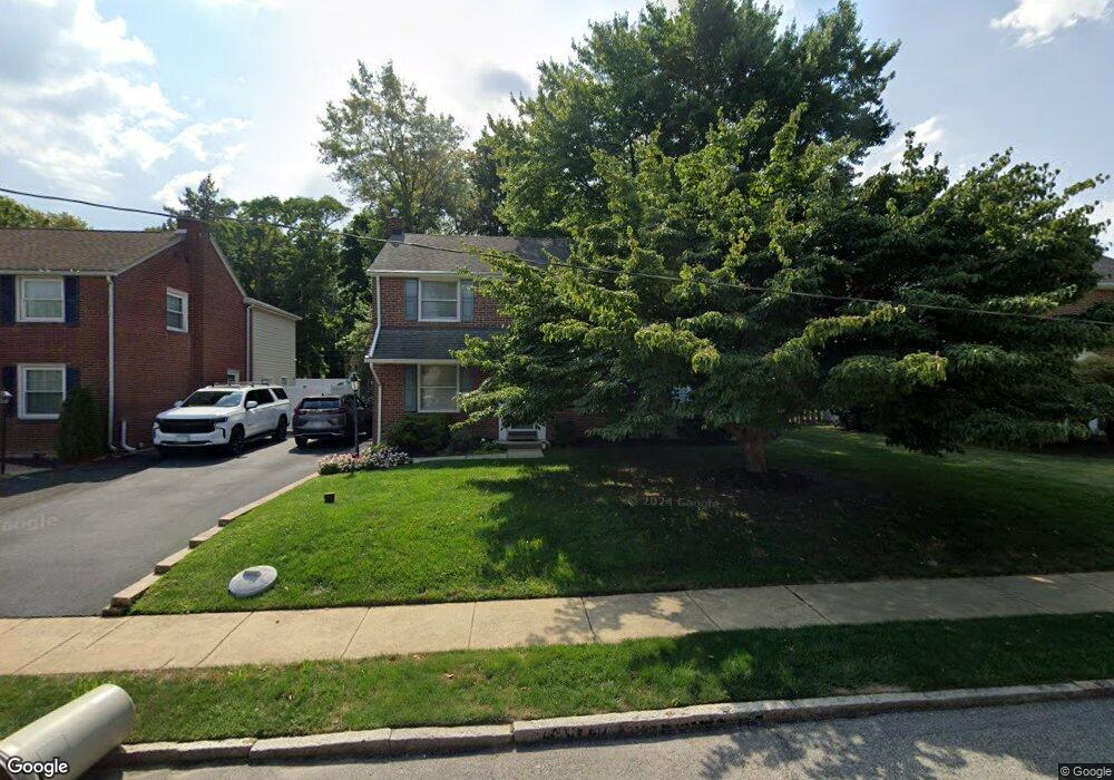
465 Wheatsheaf Rd Springfield, PA 19064
Estimated Value: $394,000 - $463,246
3
Beds
1
Bath
1,502
Sq Ft
$291/Sq Ft
Est. Value
About This Home
This home is located at 465 Wheatsheaf Rd, Springfield, PA 19064 and is currently estimated at $437,062, approximately $290 per square foot. 465 Wheatsheaf Rd is a home located in Delaware County with nearby schools including Springfield High School, St Francis Of Assisi School, and Holy Cross School.
Ownership History
Date
Name
Owned For
Owner Type
Purchase Details
Closed on
Nov 3, 1999
Sold by
Martynowicz Ted E and Martynowicz Ruth T
Bought by
Martynowicz Ruth T
Current Estimated Value
Home Financials for this Owner
Home Financials are based on the most recent Mortgage that was taken out on this home.
Original Mortgage
$52,500
Interest Rate
7.32%
Create a Home Valuation Report for This Property
The Home Valuation Report is an in-depth analysis detailing your home's value as well as a comparison with similar homes in the area
Home Values in the Area
Average Home Value in this Area
Purchase History
| Date | Buyer | Sale Price | Title Company |
|---|---|---|---|
| Martynowicz Ruth T | -- | -- |
Source: Public Records
Mortgage History
| Date | Status | Borrower | Loan Amount |
|---|---|---|---|
| Closed | Martynowicz Ruth T | $52,500 |
Source: Public Records
Tax History
| Year | Tax Paid | Tax Assessment Tax Assessment Total Assessment is a certain percentage of the fair market value that is determined by local assessors to be the total taxable value of land and additions on the property. | Land | Improvement |
|---|---|---|---|---|
| 2025 | $7,679 | $273,200 | $95,230 | $177,970 |
| 2024 | $7,679 | $273,200 | $95,230 | $177,970 |
| 2023 | $7,394 | $273,200 | $95,230 | $177,970 |
| 2022 | $7,234 | $273,200 | $95,230 | $177,970 |
| 2021 | $11,203 | $273,200 | $95,230 | $177,970 |
| 2020 | $6,692 | $147,680 | $45,780 | $101,900 |
| 2019 | $6,535 | $147,680 | $45,780 | $101,900 |
| 2018 | $6,441 | $147,680 | $0 | $0 |
| 2017 | $6,292 | $147,680 | $0 | $0 |
| 2016 | $810 | $147,680 | $0 | $0 |
| 2015 | $827 | $147,680 | $0 | $0 |
| 2014 | $810 | $147,680 | $0 | $0 |
Source: Public Records
Map
Nearby Homes
- 493 Wheatsheaf Rd
- 364 S Rolling Rd
- 227 E Leamy Ave
- 249 Gleaves Rd
- 264 Pancoast Ave
- 720 Evans Rd
- 1364 Nicklaus Dr Unit O126
- 1299 Country Club Dr Unit Q141
- 1363 Palmer Dr Unit O122
- 1291 Country Club Dr Unit Q137
- 1433 Country Club Dr Unit T214
- 658 E Leamy Ave
- 436 Kerr Ln
- 933 Greenbriar Ln
- 226 Lynbrooke Rd
- 225 Lynbrooke Rd
- 147 Snyder Ln
- 238 Alliston Rd
- 1588 Nicklaus Dr Unit H65
- 114 Providence Rd
- 471 Wheatsheaf Rd
- 461 Wheatsheaf Rd
- 457 Wheatsheaf Rd
- 475 Wheatsheaf Rd
- 453 Wheatsheaf Rd
- 479 Wheatsheaf Rd
- 466 Wheatsheaf Rd
- 462 Wheatsheaf Rd
- 472 Wheatsheaf Rd
- 456 Wheatsheaf Rd
- 447 Wheatsheaf Rd
- 468 Prospect Rd
- 476 Wheatsheaf Rd
- 476 Prospect Rd
- 460 Prospect Rd
- 483 Powell Rd
- 452 Wheatsheaf Rd
- 456 Prospect Rd
- 482 Wheatsheaf Rd
- 443 Wheatsheaf Rd
Your Personal Tour Guide
Ask me questions while you tour the home.