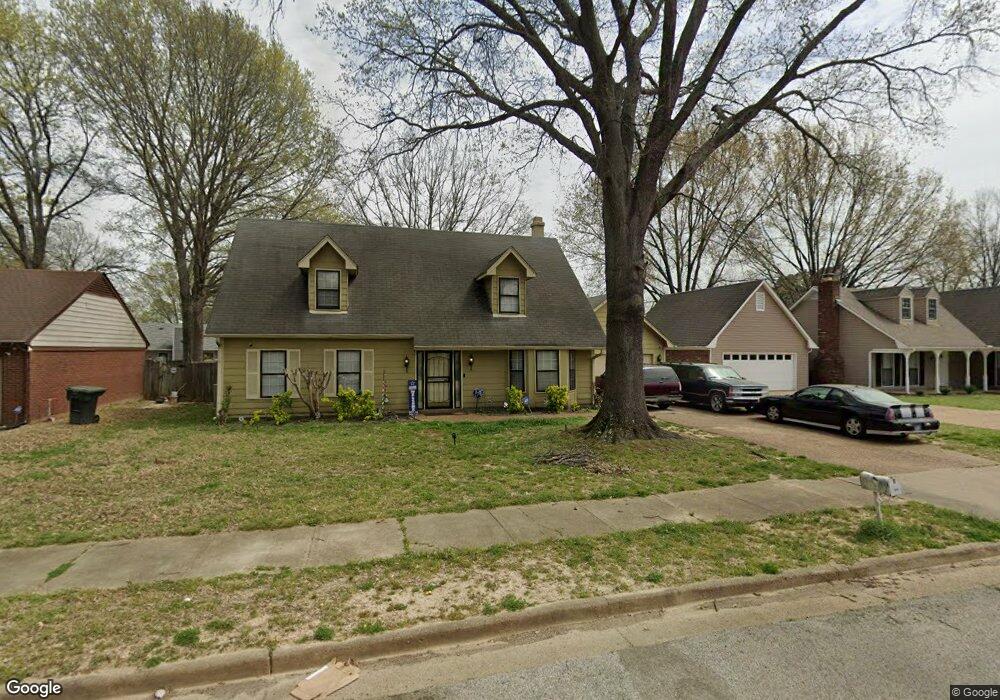
4650 Leash Ln Memphis, TN 38141
Hickory Hill NeighborhoodEstimated Value: $216,621 - $237,000
4
Beds
3
Baths
2,870
Sq Ft
$80/Sq Ft
Est. Value
About This Home
This home is located at 4650 Leash Ln, Memphis, TN 38141 and is currently estimated at $230,155, approximately $80 per square foot. 4650 Leash Ln is a home located in Shelby County with nearby schools including Ross Elementary School, Kirby High School, and Power Center Academy - Southeast.
Ownership History
Date
Name
Owned For
Owner Type
Purchase Details
Closed on
May 19, 1999
Sold by
Cordell Jarold L and Cordell Stacy
Bought by
Cole Melvin J
Current Estimated Value
Home Financials for this Owner
Home Financials are based on the most recent Mortgage that was taken out on this home.
Original Mortgage
$110,092
Outstanding Balance
$26,986
Interest Rate
6.9%
Mortgage Type
FHA
Estimated Equity
$203,169
Create a Home Valuation Report for This Property
The Home Valuation Report is an in-depth analysis detailing your home's value as well as a comparison with similar homes in the area
Home Values in the Area
Average Home Value in this Area
Purchase History
| Date | Buyer | Sale Price | Title Company |
|---|---|---|---|
| Cole Melvin J | $111,000 | Southern Trust Title Company | |
| Cole Melvin J | $111,000 | Southern Trust Title Company |
Source: Public Records
Mortgage History
| Date | Status | Borrower | Loan Amount |
|---|---|---|---|
| Open | Cole Melvin J | $110,092 | |
| Closed | Cole Melvin J | $110,092 |
Source: Public Records
Tax History
| Year | Tax Paid | Tax Assessment Tax Assessment Total Assessment is a certain percentage of the fair market value that is determined by local assessors to be the total taxable value of land and additions on the property. | Land | Improvement |
|---|---|---|---|---|
| 2025 | $1,214 | $54,025 | $6,125 | $47,900 |
| 2024 | $1,214 | $35,825 | $5,450 | $30,375 |
| 2023 | $2,182 | $35,825 | $5,450 | $30,375 |
| 2022 | $2,182 | $35,825 | $5,450 | $30,375 |
| 2021 | $2,208 | $35,825 | $5,450 | $30,375 |
| 2020 | $1,984 | $27,375 | $5,450 | $21,925 |
| 2019 | $1,984 | $27,375 | $5,450 | $21,925 |
| 2018 | $1,984 | $27,375 | $5,450 | $21,925 |
| 2017 | $1,125 | $27,375 | $5,450 | $21,925 |
| 2016 | $1,203 | $27,525 | $0 | $0 |
| 2014 | $1,203 | $27,525 | $0 | $0 |
Source: Public Records
Map
Nearby Homes
- 4811 Sturbridge Ln
- 4574 Ross Rd
- 6846 Gilford Dr
- 6781 Henredon Dr
- 6732 Henredon Dr
- 4741 Ross Creek Dr
- 6767 Smokey Ln
- 7105 Cutter Mill Rd
- 4765 Barkshire Dr
- 6770 Castlegate Ln
- 6767 Castlegate Cove
- 4313 Willow Way Cove
- 7014 Autumn Crest Cove
- 4331 Crimson Leaf Cove
- 6803 Devenshire Ln
- 4768 Bradfield Run
- 6577 Chauncey
- 6459 Summer Creek E
- 6932 Snyder Rd
- 7147 Country Oaks Dr
- 4642 Leash Ln
- 4660 Leash Ln
- 4649 Limestone Ln
- 4641 Limestone Ln
- 6872 Cleary Dr
- 4634 Leash Ln
- 4651 Leash Ln
- 4643 Leash Ln
- 6842 Cleary Dr
- 4633 Limestone Ln
- 4635 Leash Ln
- 4626 Leash Ln
- 6855 Cleary Dr
- 6863 Cleary Dr
- 4625 Limestone Ln
- 4627 Leash Ln
- 6847 Cleary Dr
- 6871 Cleary Dr
- 4652 Benoit Dr
- 4648 Limestone Ln
Your Personal Tour Guide
Ask me questions while you tour the home.