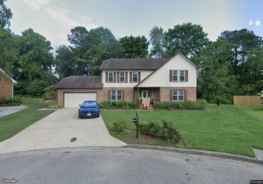
4657 Leeward Dr Chesapeake, VA 23321
Western Branch NeighborhoodEstimated Value: $508,000 - $551,000
4
Beds
3
Baths
2,624
Sq Ft
$201/Sq Ft
Est. Value
About This Home
This home is located at 4657 Leeward Dr, Chesapeake, VA 23321 and is currently estimated at $527,489, approximately $201 per square foot. 4657 Leeward Dr is a home located in Chesapeake City with nearby schools including Edwin W. Chittum Elementary School, Jolliff Middle School, and Western Branch High School.
Ownership History
Date
Name
Owned For
Owner Type
Purchase Details
Closed on
Jan 6, 2020
Sold by
Angus Theresa S
Bought by
Angus Theresa S and Lake Richard L
Current Estimated Value
Home Financials for this Owner
Home Financials are based on the most recent Mortgage that was taken out on this home.
Original Mortgage
$86,500
Interest Rate
3.6%
Mortgage Type
New Conventional
Create a Home Valuation Report for This Property
The Home Valuation Report is an in-depth analysis detailing your home's value as well as a comparison with similar homes in the area
Home Values in the Area
Average Home Value in this Area
Purchase History
| Date | Buyer | Sale Price | Title Company |
|---|---|---|---|
| Angus Theresa S | -- | None Available |
Source: Public Records
Mortgage History
| Date | Status | Borrower | Loan Amount |
|---|---|---|---|
| Closed | Angus Theresa S | $86,500 |
Source: Public Records
Tax History
| Year | Tax Paid | Tax Assessment Tax Assessment Total Assessment is a certain percentage of the fair market value that is determined by local assessors to be the total taxable value of land and additions on the property. | Land | Improvement |
|---|---|---|---|---|
| 2025 | $4,665 | $456,200 | $165,000 | $291,200 |
| 2024 | $4,665 | $461,900 | $160,000 | $301,900 |
| 2023 | $3,993 | $443,200 | $140,000 | $303,200 |
| 2022 | $3,945 | $390,600 | $120,000 | $270,600 |
| 2021 | $3,604 | $343,200 | $90,000 | $253,200 |
| 2020 | $3,347 | $318,800 | $90,000 | $228,800 |
| 2019 | $3,494 | $332,800 | $90,000 | $242,800 |
| 2018 | $3,494 | $268,900 | $85,000 | $183,900 |
| 2017 | $3,025 | $288,100 | $95,000 | $193,100 |
| 2016 | $2,823 | $268,900 | $85,000 | $183,900 |
| 2015 | $2,771 | $263,900 | $80,000 | $183,900 |
| 2014 | $2,771 | $263,900 | $80,000 | $183,900 |
Source: Public Records
Map
Nearby Homes
- 2156 Seastone Trace
- 2133 Portsmouth Blvd
- 2200 Christopher Dr
- 4316 Hillingdon Bend Unit 304
- 4225 Coffman Blvd
- 4332 Farringdon Way
- 2644 Leytonstone Dr
- MM Sorrento Rd
- 2455 Leytonstone Dr Unit 63
- 2506 Leytonstone Dr
- 4108 Santa Maria Dr
- 4100 Mystic Cove
- MM Bayberry
- MM the Grove (Laurel)
- MM Myrtle II
- 2801 Baldwin Dr
- 2521 Drum Creek Rd
- 2330 Alcott Way
- 4073 Maple Dr
- 1908 Rosemary Ln
- 4658 Leeward Dr
- 4653 Leeward Dr
- 4656 Leeward Dr
- 4645 Leeward Dr
- 4652 Leeward Dr
- 2031 Armada Ct
- 4701 Leeward Ct
- 2033 Armada Ct
- 2025 Armada Dr
- 4648 Leeward Dr
- 2027 Armada Ct
- 4641 Leeward Dr
- 2021 Armada Dr
- 4700 Leeward Ct
- 2017 Armada Dr
- 2032 Armada Ct
- 4640 Leeward Dr
- 2013 Armada Dr
- 4704 Leeward Ct
- 2024 Armada Dr
Your Personal Tour Guide
Ask me questions while you tour the home.