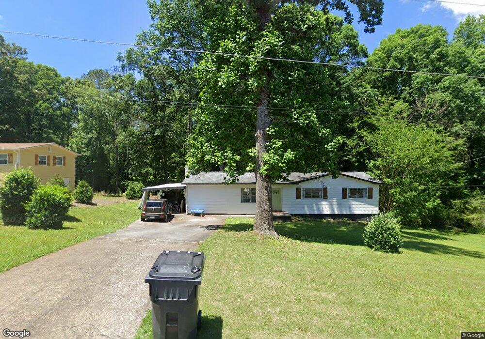
4657 Patrick Dr NE Kennesaw, GA 30144
Sandy Plains NeighborhoodEstimated Value: $280,000 - $329,000
3
Beds
2
Baths
1,344
Sq Ft
$227/Sq Ft
Est. Value
About This Home
This home is located at 4657 Patrick Dr NE, Kennesaw, GA 30144 and is currently estimated at $304,968, approximately $226 per square foot. 4657 Patrick Dr NE is a home located in Cobb County with nearby schools including Nicholson Elementary School, McCleskey Middle School, and Kell High School.
Ownership History
Date
Name
Owned For
Owner Type
Purchase Details
Closed on
Aug 3, 2022
Sold by
Amy Hollingshead
Bought by
Hollingshead Amy and Turcot Jesse Elizabeth
Current Estimated Value
Purchase Details
Closed on
Jun 30, 2011
Sold by
Federal Natl Mtg Assn Fnma
Bought by
Hollingshead Amy
Home Financials for this Owner
Home Financials are based on the most recent Mortgage that was taken out on this home.
Original Mortgage
$30,000
Interest Rate
4.62%
Mortgage Type
New Conventional
Purchase Details
Closed on
Jan 4, 2011
Sold by
Russell Oliver
Bought by
Federal National Mortgage Association
Purchase Details
Closed on
May 5, 2006
Sold by
Southern Willie L and Southern Peggy F
Bought by
Russell Oliver
Home Financials for this Owner
Home Financials are based on the most recent Mortgage that was taken out on this home.
Original Mortgage
$120,000
Interest Rate
6.39%
Mortgage Type
New Conventional
Create a Home Valuation Report for This Property
The Home Valuation Report is an in-depth analysis detailing your home's value as well as a comparison with similar homes in the area
Home Values in the Area
Average Home Value in this Area
Purchase History
| Date | Buyer | Sale Price | Title Company |
|---|---|---|---|
| Hollingshead Amy | -- | None Listed On Document | |
| Hollingshead Amy | $35,000 | -- | |
| Federal National Mortgage Association | $95,700 | -- | |
| Russell Oliver | $120,000 | -- |
Source: Public Records
Mortgage History
| Date | Status | Borrower | Loan Amount |
|---|---|---|---|
| Previous Owner | Hollingshead Amy | $30,000 | |
| Previous Owner | Russell Oliver | $120,000 |
Source: Public Records
Tax History Compared to Growth
Tax History
| Year | Tax Paid | Tax Assessment Tax Assessment Total Assessment is a certain percentage of the fair market value that is determined by local assessors to be the total taxable value of land and additions on the property. | Land | Improvement |
|---|---|---|---|---|
| 2024 | $3,212 | $106,528 | $26,000 | $80,528 |
| 2023 | $2,574 | $85,364 | $22,000 | $63,364 |
| 2022 | $2,280 | $75,112 | $18,000 | $57,112 |
| 2021 | $1,726 | $56,864 | $14,000 | $42,864 |
| 2020 | $1,513 | $49,848 | $8,000 | $41,848 |
| 2019 | $1,513 | $49,848 | $8,000 | $41,848 |
| 2018 | $1,270 | $41,848 | $8,000 | $33,848 |
| 2017 | $1,203 | $41,848 | $8,000 | $33,848 |
| 2016 | $948 | $32,976 | $6,000 | $26,976 |
| 2015 | $784 | $26,600 | $6,000 | $20,600 |
| 2014 | $790 | $26,600 | $0 | $0 |
Source: Public Records
Map
Nearby Homes
- 4704 Lincoln Dr NE
- The Gavin E Plan at The Village at Shallowford - Signature Series
- The Marion A Plan at The Village at Shallowford - Classic Series
- The Cary A Plan at The Village at Shallowford - Classic Series
- 4669 Blue Topaz Trail
- 707 Smokey Quartz Way
- 710 Smokey Quartz Way
- 694 Smokey Quartz Way
- 4785 Moonstone NE
- 703 Smokey Quartz Way
- 706 Smokey Quartz Way
- 702 Smokey Quartz Way
- 4778 Moonstone NE
- 639 Tigers Eye Terrace
- 4785 Moonstone Trace
- 4667 Patrick Dr NE
- 4647 Patrick Dr NE
- 4652 Patrick Dr NE
- 4637 Patrick Dr NE
- 4675 Patrick Dr NE
- 669 Gettysburg Trail NE
- 4642 Patrick Dr NE
- 4627 Patrick Dr NE
- 679 Gettysburg Trail NE
- 679 Gettysburg Trail NE Unit 2
- 690 Gettysburg Trail NE Unit 1
- 4632 Patrick Dr NE
- 4685 Patrick Dr NE Unit 2
- 0 Gettysburg Trail Unit 7024903
- 0 Gettysburg Trail Unit 7058132
- 0 Gettysburg Trail Unit 7183825
- 0 Gettysburg Trail
- 4753 Lincoln Dr NE
- 4604 Battle Ct NE
- 4617 Patrick Dr NE