Estimated Value: $303,101 - $313,000
3
Beds
3
Baths
2,036
Sq Ft
$151/Sq Ft
Est. Value
About This Home
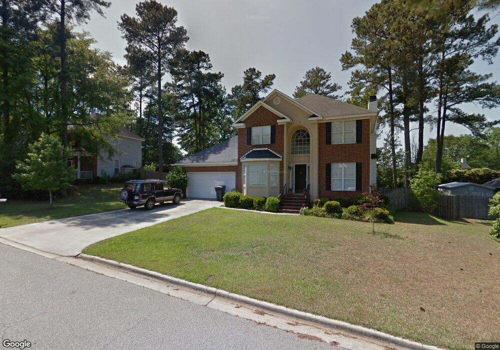
This home is located at 4659 La Pointe, Evans, GA 30809 and is currently estimated at $308,275, approximately $151 per square foot. 4659 La Pointe is a home located in Columbia County with nearby schools including Evans Elementary School, Evans Middle School, and Evans High School.
Ownership History
Date
Name
Owned For
Owner Type
Purchase Details
Closed on
Feb 17, 2003
Sold by
Wessling Eric D
Bought by
Wessling Eric D and Wessling Elizabeth G
Current Estimated Value
Purchase Details
Closed on
Feb 27, 2002
Sold by
Head Russell T and Head Sadonna L
Bought by
Wessling Eric D
Home Financials for this Owner
Home Financials are based on the most recent Mortgage that was taken out on this home.
Original Mortgage
$136,700
Interest Rate
6.8%
Mortgage Type
FHA
Create a Home Valuation Report for This Property
The Home Valuation Report is an in-depth analysis detailing your home's value as well as a comparison with similar homes in the area
Home Values in the Area
Average Home Value in this Area
Purchase History
| Date | Buyer | Sale Price | Title Company |
|---|---|---|---|
| Wessling Eric D | -- | -- | |
| Wessling Eric D | $138,900 | -- |
Source: Public Records
Mortgage History
| Date | Status | Borrower | Loan Amount |
|---|---|---|---|
| Previous Owner | Wessling Eric D | $136,700 |
Source: Public Records
Tax History
| Year | Tax Paid | Tax Assessment Tax Assessment Total Assessment is a certain percentage of the fair market value that is determined by local assessors to be the total taxable value of land and additions on the property. | Land | Improvement |
|---|---|---|---|---|
| 2025 | $2,930 | $122,368 | $23,404 | $98,964 |
| 2024 | $2,791 | $111,305 | $20,804 | $90,501 |
| 2023 | $2,791 | $91,269 | $17,404 | $73,865 |
| 2022 | $2,524 | $96,827 | $18,804 | $78,023 |
| 2021 | $2,487 | $91,280 | $16,604 | $74,676 |
| 2020 | $2,140 | $76,914 | $15,304 | $61,610 |
| 2019 | $2,211 | $79,450 | $14,404 | $65,046 |
| 2018 | $2,217 | $79,377 | $14,404 | $64,973 |
| 2017 | $2,077 | $74,107 | $13,704 | $60,403 |
| 2016 | $1,934 | $71,566 | $12,580 | $58,986 |
| 2015 | $1,918 | $70,851 | $12,480 | $58,371 |
| 2014 | $1,884 | $68,721 | $12,480 | $56,241 |
Source: Public Records
Map
Nearby Homes
- 642 Kimberley Place
- 665 Steeplechase Way
- 305 Sumac Trail
- 3542 Hilltop Trail
- 3527 Hilltop Trail
- 3538 Hilltop Trail
- 599 Windward Ct
- 604 Kimberley Place
- 4614 Stoneridge Ct
- 703 Low Meadow Dr
- 4712 Walnut Hill Dr
- 4653 Washington Rd
- 726 Whitney Shoals Rd
- 881 Audubon Way
- 814 Audubon Way
- 1 Woodbridge Way
- 4560 Mulberry Creek Dr
- 648 River Oaks Ln
- 4622 Brittany Dr
- 4793 Silver Lake Dr
- 4657 La Pointe
- 4661 La Pointe
- 645 Kimberly Place
- 645 Kimberley Place
- 647 Kimberly Place
- 647 Kimberley Place
- 643 Kimberly Place
- 4655 La Pointe
- 4662 La Pointe
- 4660 La Pointe
- 4663 La Pointe
- 4666 La Pointe
- 641 Kimberly Place
- 641 Kimberley Place
- 641 Kimberley Place
- 649 Kimberly Place
- 4658 La Pointe
- 4653 La Pointe
- 639 Kimberly Place
- 639 Kimberley Place
Your Personal Tour Guide
Ask me questions while you tour the home.