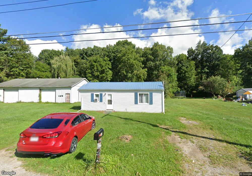
467 Annadale Ave Mansfield, OH 44905
Estimated Value: $71,130 - $142,000
Studio
1
Bath
--
Sq Ft
9,148
Sq Ft Lot
About This Home
This home is located at 467 Annadale Ave, Mansfield, OH 44905 and is currently estimated at $101,033. 467 Annadale Ave is a home located in Richland County with nearby schools including Temple-Christian School, St. Mary Catholic School, and St. Peter's Elementary/Montessori School.
Ownership History
Date
Name
Owned For
Owner Type
Purchase Details
Closed on
Sep 1, 2015
Sold by
Richland County Land Reutilization Corpo
Bought by
Boroff Daniel W
Current Estimated Value
Purchase Details
Closed on
Aug 27, 2014
Sold by
State Of Ohio
Bought by
Richland County Land Reutilization Corpo
Purchase Details
Closed on
Apr 23, 2001
Sold by
Edwards Harold W
Bought by
Cook Chad
Home Financials for this Owner
Home Financials are based on the most recent Mortgage that was taken out on this home.
Original Mortgage
$30,400
Interest Rate
12.99%
Mortgage Type
New Conventional
Purchase Details
Closed on
Oct 1, 1985
Create a Home Valuation Report for This Property
The Home Valuation Report is an in-depth analysis detailing your home's value as well as a comparison with similar homes in the area
Home Values in the Area
Average Home Value in this Area
Purchase History
| Date | Buyer | Sale Price | Title Company |
|---|---|---|---|
| Boroff Daniel W | -- | None Available | |
| Richland County Land Reutilization Corpo | -- | None Available | |
| Cook Chad | $32,000 | -- | |
| -- | $4,000 | -- |
Source: Public Records
Mortgage History
| Date | Status | Borrower | Loan Amount |
|---|---|---|---|
| Previous Owner | Cook Chad | $30,400 |
Source: Public Records
Tax History
| Year | Tax Paid | Tax Assessment Tax Assessment Total Assessment is a certain percentage of the fair market value that is determined by local assessors to be the total taxable value of land and additions on the property. | Land | Improvement |
|---|---|---|---|---|
| 2024 | $8 | $140 | $140 | $0 |
| 2023 | $8 | $140 | $140 | $0 |
| 2022 | $9 | $130 | $130 | $0 |
| 2021 | $9 | $130 | $130 | $0 |
| 2020 | $9 | $130 | $130 | $0 |
| 2019 | $9 | $110 | $110 | $0 |
| 2018 | $8 | $110 | $110 | $0 |
| 2017 | $8 | $110 | $110 | $0 |
| 2016 | $8 | $100 | $100 | $0 |
| 2015 | $726 | $10,350 | $3,000 | $7,350 |
| 2014 | $1,436 | $10,350 | $3,000 | $7,350 |
| 2012 | $1,306 | $10,900 | $3,160 | $7,740 |
Source: Public Records
Map
Nearby Homes
- 0 Wesley
- 573 Caldwell Ave
- 411 Grace St
- 943 Yale Ave
- 387 Auburn St
- 346 Newman St
- 0 Lenox Ave
- 382 Orange St
- 118 Raymond Ave
- 580 N Mulberry St
- 0 Grant Rd Unit 5190994
- 524 Lida St
- 1168 ConcheMcO St
- 961 Neil Cir N
- 888 Beal Rd
- 1359 N Stewart Rd
- 1217 Evergreen Ave W
- 646 Fleetwood Rd
- 644 Skyline Rd
- 607 Skyline Rd
- 473 Annadale Ave
- 463 Annadale Ave
- 483 Annadale Ave
- 487 Annadale Ave
- 445 Annadale Ave
- 493 Annadale Ave
- 492 Annadale Ave
- 499 Annadale Ave
- 901 5th Ave
- 0 Annadale
- 507 Annadale Ave
- 512 Annadale Ave
- 519 Annadale Ave
- 518 Annadale Ave
- 425 Annadale Ave
- 878 Olivesburg Rd
- 437 Annadale Ave
- 421 Annadale Ave
- 529 Annadale Ave
- 529 Annadale Ave
Your Personal Tour Guide
Ask me questions while you tour the home.