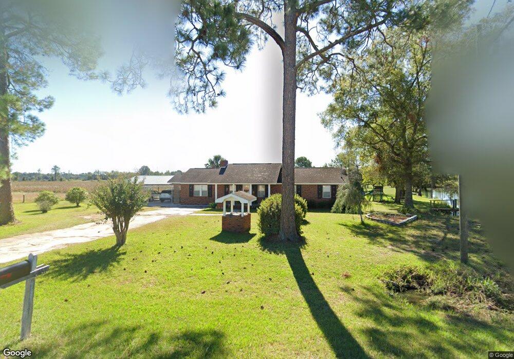
467 Broxton Hwy Hazlehurst, GA 31539
Estimated Value: $200,254 - $216,000
3
Beds
2
Baths
1,520
Sq Ft
$137/Sq Ft
Est. Value
About This Home
This home is located at 467 Broxton Hwy, Hazlehurst, GA 31539 and is currently estimated at $208,814, approximately $137 per square foot. 467 Broxton Hwy is a home located in Jeff Davis County with nearby schools including Jeff Davis Primary School, Jeff Davis Elementary School, and Jeff Davis Middle School.
Ownership History
Date
Name
Owned For
Owner Type
Purchase Details
Closed on
Nov 7, 2024
Sold by
Pickren Trowell Elizabeth
Bought by
Trowell Elizabeth A and Trowell Nicholas A
Current Estimated Value
Purchase Details
Closed on
Sep 5, 2024
Sold by
Pickren Wendell
Bought by
Pickren Trowell Elizabeth
Purchase Details
Closed on
Apr 5, 2000
Bought by
Pickren Wendell and Pickren Linda
Purchase Details
Closed on
Aug 4, 1995
Bought by
Pickren Wendell and Pickren Linda
Purchase Details
Closed on
Jan 1, 1974
Bought by
Pickren Herbert A
Create a Home Valuation Report for This Property
The Home Valuation Report is an in-depth analysis detailing your home's value as well as a comparison with similar homes in the area
Home Values in the Area
Average Home Value in this Area
Purchase History
| Date | Buyer | Sale Price | Title Company |
|---|---|---|---|
| Trowell Elizabeth A | -- | -- | |
| Pickren Trowell Elizabeth | -- | -- | |
| Pickren Wendell | $1,500 | -- | |
| Pickren Wendell | $45,000 | -- | |
| Pickren Herbert A | -- | -- |
Source: Public Records
Tax History Compared to Growth
Tax History
| Year | Tax Paid | Tax Assessment Tax Assessment Total Assessment is a certain percentage of the fair market value that is determined by local assessors to be the total taxable value of land and additions on the property. | Land | Improvement |
|---|---|---|---|---|
| 2024 | $1,653 | $58,256 | $12,240 | $46,016 |
| 2023 | $1,041 | $37,416 | $4,732 | $32,684 |
| 2022 | $1,041 | $37,416 | $4,732 | $32,684 |
| 2021 | $1,041 | $37,416 | $4,732 | $32,684 |
| 2020 | $1,041 | $37,416 | $4,732 | $32,684 |
| 2019 | $1,041 | $37,416 | $4,732 | $32,684 |
| 2018 | $1,041 | $37,416 | $4,732 | $32,684 |
| 2017 | $985 | $36,091 | $4,732 | $31,359 |
| 2016 | $968 | $36,091 | $4,732 | $31,359 |
| 2015 | -- | $36,091 | $4,732 | $31,359 |
| 2014 | -- | $36,532 | $4,732 | $31,800 |
Source: Public Records
Map
Nearby Homes
- 102 W Palm Rd
- 393 Douglas Hwy
- 37 Dogwood Rd
- 0 Collins St
- 74 Leslie Rd
- 74 74 Leslie Rd
- 16 Beech Rd
- 34 Bradford Ln
- 77 Jimmy Boatright Dr
- 371 Burketts Ferry Rd
- 185 S Cromartie St
- 27 Park Ln
- 00 Pat Dixon St & Charles Rogers Blvd
- 11 Holy Hill Rd
- 42 Claxton Rd
- 0 Charles Rogers Blvd
- 53 Mockingbird Ln
- 44 Kersey St
- 45 Elton St
- 116 Walton Way
- 459 Broxton Hwy
- 480 Broxton Hwy
- 447 Broxton Hwy
- 494 Broxton Hwy
- 126 Kirkland Still Rd
- 93 Kendall Stone Rd
- 85 W Palm Rd
- 103 W Palm Rd
- 81 Kendall Stone Rd
- 107 W Palm Rd
- 18 S Seminole Ln
- 79 W Palm Rd
- 111 W Palm Rd
- 239 Broxton Hwy
- 239 Broxton Hwy
- 428 Douglas Hwy
- 26 W Camellia Rd
- 80 W Palm Rd
- 38 Marchant Field
- 163 John Long Rd