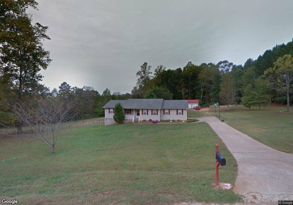
467 E Freeman St Maysville, GA 30558
Estimated Value: $292,000 - $476,654
6
Beds
3
Baths
2,689
Sq Ft
$145/Sq Ft
Est. Value
About This Home
This home is located at 467 E Freeman St, Maysville, GA 30558 and is currently estimated at $389,414, approximately $144 per square foot. 467 E Freeman St is a home located in Banks County with nearby schools including Banks County Primary School, Banks County Elementary School, and Banks County Middle School.
Ownership History
Date
Name
Owned For
Owner Type
Purchase Details
Closed on
Jan 31, 2022
Sold by
Crowe Christopher A
Bought by
Ingraldi Frank and Ingraldi Dawn
Current Estimated Value
Home Financials for this Owner
Home Financials are based on the most recent Mortgage that was taken out on this home.
Original Mortgage
$150,000
Outstanding Balance
$138,772
Interest Rate
3.56%
Mortgage Type
Cash
Estimated Equity
$250,642
Purchase Details
Closed on
Mar 30, 2005
Sold by
Hill Dorothy J
Bought by
Crowe Christopher A and Crowe Tiffany
Home Financials for this Owner
Home Financials are based on the most recent Mortgage that was taken out on this home.
Original Mortgage
$138,150
Interest Rate
5.74%
Mortgage Type
New Conventional
Create a Home Valuation Report for This Property
The Home Valuation Report is an in-depth analysis detailing your home's value as well as a comparison with similar homes in the area
Home Values in the Area
Average Home Value in this Area
Purchase History
| Date | Buyer | Sale Price | Title Company |
|---|---|---|---|
| Ingraldi Frank | $420,000 | -- | |
| Crowe Christopher A | $153,500 | -- |
Source: Public Records
Mortgage History
| Date | Status | Borrower | Loan Amount |
|---|---|---|---|
| Open | Ingraldi Frank | $150,000 | |
| Previous Owner | Crowe Christopher A | $138,150 |
Source: Public Records
Tax History Compared to Growth
Tax History
| Year | Tax Paid | Tax Assessment Tax Assessment Total Assessment is a certain percentage of the fair market value that is determined by local assessors to be the total taxable value of land and additions on the property. | Land | Improvement |
|---|---|---|---|---|
| 2025 | $2,781 | $146,635 | $39,916 | $106,719 |
| 2024 | $2,876 | $138,934 | $36,287 | $102,647 |
| 2023 | $2,830 | $131,838 | $39,761 | $92,077 |
| 2022 | $1,930 | $90,549 | $28,687 | $61,862 |
| 2021 | $1,690 | $74,614 | $21,545 | $53,069 |
| 2020 | $1,622 | $69,779 | $17,309 | $52,470 |
| 2019 | $1,630 | $69,779 | $17,309 | $52,470 |
| 2018 | $1,736 | $73,057 | $25,369 | $47,688 |
Source: Public Records
Map
Nearby Homes
- 0 H D R Dr Unit 10637398
- 0 H D R Dr Unit 7676406
- 0 H D R Dr Unit 10637403
- 199 Deadwyler Rd
- Plan 2604 at Eagle Heights
- Plan 2505 at Eagle Heights
- Plan 2906 at Eagle Heights
- Plan 1709 at Eagle Heights
- Plan 1826 at Eagle Heights
- Plan 2628 at Eagle Heights
- Plan 2239 at Eagle Heights
- Plan 1902 at Eagle Heights
- Plan 2307 at Eagle Heights
- Plan 2700 at Eagle Heights
- Plan 2328 at Eagle Heights
- Plan 2421 at Eagle Heights
- Plan 2100 at Eagle Heights
- Plan 2316 at Eagle Heights
- 104 Eagle Heights Dr
- 393 W Freeman St
- 371 E Freeman St
- 335 E Freeman St
- 489 E Freeman St
- 474 E Freeman St
- 492 E Freeman St
- 494 E Freeman St
- 360 E Freeman St
- 493 E Freeman St
- 320 E Freeman St
- E E Freeman St Unit 5
- E E Freeman St Unit LOT 3
- Lot 3 E Freeman St
- E E Freeman St
- 403 Mitchell Rd
- 289 Mitchell Rd
- 287 Mitchell Rd
- 262 Highway 52
- 72 N Main St
- 10325 Gillsville Rd
- 165 E Freeman St