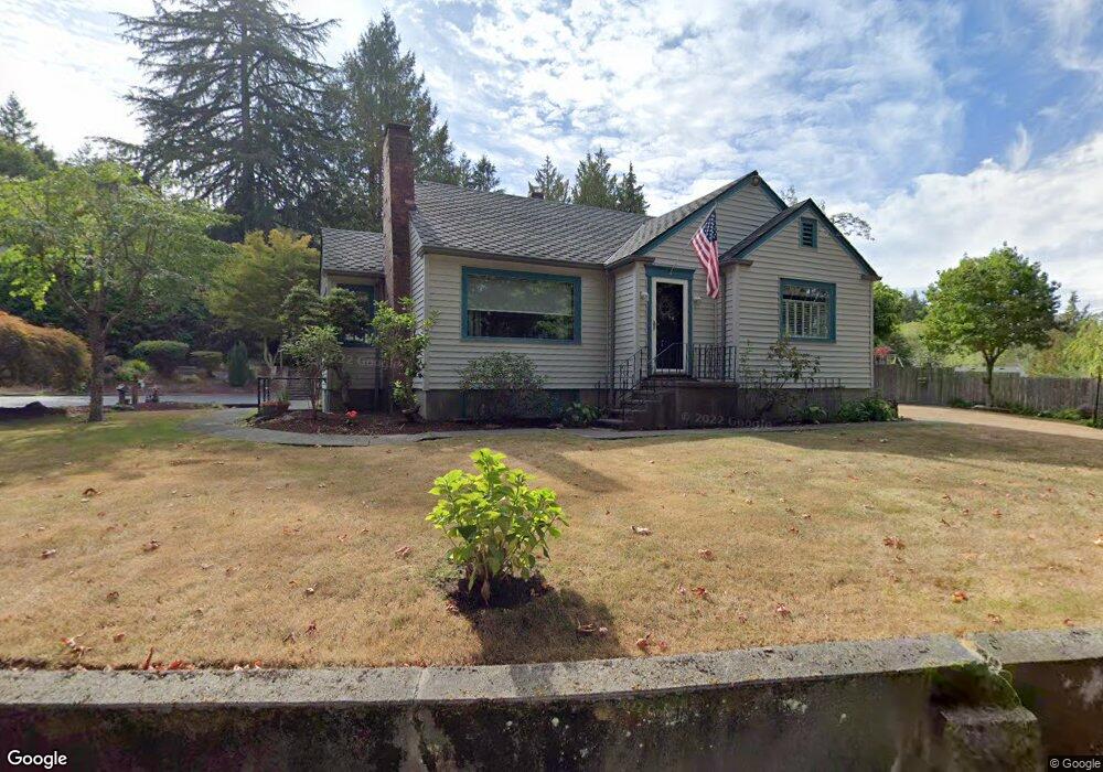
4675 Hawthorne Ave W Port Orchard, WA 98367
Gorst NeighborhoodEstimated Value: $411,000 - $480,000
2
Beds
2
Baths
1,079
Sq Ft
$411/Sq Ft
Est. Value
About This Home
This home is located at 4675 Hawthorne Ave W, Port Orchard, WA 98367 and is currently estimated at $443,745, approximately $411 per square foot. 4675 Hawthorne Ave W is a home located in Kitsap County with nearby schools including Sunnyslope Elementary School, Cedar Heights Middle School, and South Kitsap High School.
Ownership History
Date
Name
Owned For
Owner Type
Purchase Details
Closed on
Sep 17, 1999
Sold by
Fragiao Nancy R
Bought by
Fragiao Julian and Fragiao Nancy R
Current Estimated Value
Purchase Details
Closed on
Sep 8, 1999
Sold by
Phillips David L
Bought by
Fragiao Nancy R
Create a Home Valuation Report for This Property
The Home Valuation Report is an in-depth analysis detailing your home's value as well as a comparison with similar homes in the area
Home Values in the Area
Average Home Value in this Area
Purchase History
| Date | Buyer | Sale Price | Title Company |
|---|---|---|---|
| Fragiao Julian | -- | -- | |
| Fragiao Nancy R | -- | -- |
Source: Public Records
Tax History Compared to Growth
Tax History
| Year | Tax Paid | Tax Assessment Tax Assessment Total Assessment is a certain percentage of the fair market value that is determined by local assessors to be the total taxable value of land and additions on the property. | Land | Improvement |
|---|---|---|---|---|
| 2026 | $3,392 | $383,410 | $75,890 | $307,520 |
| 2025 | $3,392 | $383,410 | $75,890 | $307,520 |
| 2024 | $3,290 | $383,410 | $75,890 | $307,520 |
| 2023 | $3,267 | $383,410 | $75,890 | $307,520 |
| 2022 | $3,140 | $308,560 | $60,490 | $248,070 |
| 2021 | $2,992 | $278,170 | $54,990 | $223,180 |
| 2020 | $2,591 | $232,890 | $56,810 | $176,080 |
| 2019 | $2,200 | $216,370 | $52,510 | $163,860 |
| 2018 | $2,341 | $176,740 | $45,190 | $131,550 |
| 2017 | $1,980 | $176,740 | $45,190 | $131,550 |
| 2016 | $1,945 | $158,870 | $43,040 | $115,830 |
| 2015 | $1,887 | $156,260 | $43,040 | $113,220 |
| 2014 | -- | $141,440 | $42,200 | $99,240 |
| 2013 | -- | $149,120 | $49,880 | $99,240 |
Source: Public Records
Map
Nearby Homes
- 4576 Hawthorne Ave W
- 4415 W Jarstad Dr
- 3336 Mccary Rd SW
- 44 Acres Mccary Rd SW
- 4178 Novak Dr SW
- 4833 Lone Bear Ln SW
- 4160 Dr SW Novak
- 4310 Novak Dr SW
- 4402 Lone Bear Ln SW
- 4090 Reef Rd SW
- 4070 Reef Rd SW
- 4100 Reef Rd SW
- 4060 Reef Rd SW
- 4120 Reef Rd SW
- 4130 Reef Rd SW
- 4140 Reef Rd SW
- 4040 Reef Rd SW
- 4180 Reef Rd SW
- 3951 McCormick Village Dr
- 3951 McCormick Village Dr Unit 68
- 4634 Hawthorne Ave W
- 4673 W Summit St
- 4681 W Summit St
- 4618 Hawthorne Ave W
- 4240 W Alder St
- 4201 W Alder St
- 4221 W Alder St
- 4617 Hawthorne Ave W
- 4593 Hawthorne Ave W
- 4730 W Obrian Dr
- 4730 W Summit St
- 4573 Hawthorne Ave W
- 0 Locust St Unit 1225447
- 4380 W Foote St
- 4420 W Summit St
- 4200 W Alder St
- 4220 W Alder St
- 4180 W Alder St
- 4260 W Alder St
- 4160 W Alder St