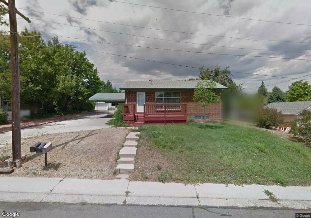
4675 Newland St Wheat Ridge, CO 80033
Barths NeighborhoodEstimated Value: $595,000 - $692,337
6
Beds
3
Baths
2,217
Sq Ft
$294/Sq Ft
Est. Value
About This Home
This home is located at 4675 Newland St, Wheat Ridge, CO 80033 and is currently estimated at $651,334, approximately $293 per square foot. 4675 Newland St is a home located in Jefferson County with nearby schools including Stevens Elementary School, Everitt Middle School, and Wheat Ridge High School.
Ownership History
Date
Name
Owned For
Owner Type
Purchase Details
Closed on
Dec 5, 2024
Sold by
Welsh Family Trust and Welsh Lon E
Bought by
Ross Eric Stephan
Current Estimated Value
Home Financials for this Owner
Home Financials are based on the most recent Mortgage that was taken out on this home.
Original Mortgage
$647,662
Outstanding Balance
$642,499
Interest Rate
6.72%
Mortgage Type
New Conventional
Estimated Equity
$8,835
Purchase Details
Closed on
Dec 3, 2020
Sold by
Conti Jeremy
Bought by
The Welsh Family Trust
Home Financials for this Owner
Home Financials are based on the most recent Mortgage that was taken out on this home.
Original Mortgage
$350,000
Interest Rate
2.8%
Mortgage Type
Credit Line Revolving
Purchase Details
Closed on
Sep 21, 2020
Sold by
4675 Newland Llc
Bought by
Conti Jeremy
Purchase Details
Closed on
May 4, 2020
Sold by
Grundman Cephora Cecile
Bought by
4675 Newland Llc
Purchase Details
Closed on
Mar 22, 2019
Sold by
Jkse Enterprises Llc
Bought by
Grundman Cephora Cecile
Home Financials for this Owner
Home Financials are based on the most recent Mortgage that was taken out on this home.
Original Mortgage
$413,000
Interest Rate
6.87%
Mortgage Type
New Conventional
Purchase Details
Closed on
Mar 29, 2007
Sold by
Us Bank Na
Bought by
Pollock Douglas G
Home Financials for this Owner
Home Financials are based on the most recent Mortgage that was taken out on this home.
Original Mortgage
$210,900
Interest Rate
11%
Mortgage Type
Purchase Money Mortgage
Purchase Details
Closed on
Nov 20, 2006
Sold by
Robbins David A
Bought by
U S Bank Na
Purchase Details
Closed on
Sep 7, 2001
Sold by
Bicker Sandra
Bought by
Robbins David A
Home Financials for this Owner
Home Financials are based on the most recent Mortgage that was taken out on this home.
Original Mortgage
$40,000
Interest Rate
8%
Mortgage Type
Seller Take Back
Create a Home Valuation Report for This Property
The Home Valuation Report is an in-depth analysis detailing your home's value as well as a comparison with similar homes in the area
Home Values in the Area
Average Home Value in this Area
Purchase History
| Date | Buyer | Sale Price | Title Company |
|---|---|---|---|
| Ross Eric Stephan | $681,750 | None Listed On Document | |
| The Welsh Family Trust | -- | First Alliance Title Llc | |
| Conti Jeremy | $488,500 | First Alliance Title | |
| 4675 Newland Llc | -- | None Available | |
| Grundman Cephora Cecile | $590,000 | Land Title Guarantee Co | |
| Pollock Douglas G | $176,900 | Security Title | |
| U S Bank Na | -- | None Available | |
| Robbins David A | $240,000 | None Available |
Source: Public Records
Mortgage History
| Date | Status | Borrower | Loan Amount |
|---|---|---|---|
| Open | Ross Eric Stephan | $647,662 | |
| Previous Owner | The Welsh Family Trust | $350,000 | |
| Previous Owner | Grundman Cephora Cecile | $413,000 | |
| Previous Owner | Pollock Douglas G | $210,900 | |
| Previous Owner | Robbins David A | $40,000 |
Source: Public Records
Tax History Compared to Growth
Tax History
| Year | Tax Paid | Tax Assessment Tax Assessment Total Assessment is a certain percentage of the fair market value that is determined by local assessors to be the total taxable value of land and additions on the property. | Land | Improvement |
|---|---|---|---|---|
| 2024 | $3,867 | $44,233 | $17,174 | $27,059 |
| 2023 | $3,867 | $44,233 | $17,174 | $27,059 |
| 2022 | $4,473 | $36,124 | $16,644 | $19,480 |
| 2021 | $3,327 | $37,915 | $17,500 | $20,415 |
| 2020 | $2,950 | $33,796 | $15,514 | $18,282 |
| 2019 | $2,911 | $33,796 | $15,514 | $18,282 |
| 2018 | $2,701 | $30,311 | $10,289 | $20,022 |
| 2017 | $2,439 | $30,311 | $10,289 | $20,022 |
| 2016 | $2,211 | $25,718 | $6,280 | $19,438 |
| 2015 | $1,781 | $25,718 | $6,280 | $19,438 |
| 2014 | $1,781 | $19,430 | $5,731 | $13,699 |
Source: Public Records
Map
Nearby Homes
- 4730 Otis St
- 4730 Pierce St
- 6920 W 48th Ave Unit 6920
- 6920 W 47th Place
- 4541 Reed St
- 4635 Teller St
- 7221 W 48th Ave
- 4420 Teller St
- 4835 Harlan St Unit 14-17
- 7010 W 44th Ave
- 6105 W 49th Place
- 4125 Pierce St
- 4295 Harlan St
- 4095 Quay St
- 4711 Wadsworth Blvd
- 6801 W 52nd Ave
- 4860 Depew St
- 4877 Chase St
- 4014 Upham St
- 4026 Upham St
- 4675 Newland St Unit C
- 4665 Newland St
- 6600 W 47th Ave
- 6650 W 47th Ave
- 4660 Otis St
- 4670 Newland St
- 6595 W 46th Place
- 4650 Otis St
- 4645 Newland St
- 4645 Newland St Unit 4
- 4645 Newland St
- 6690 W 47th Ave
- 6580 W 47th Ave
- 6650 W 46th Place
- 6575 W 46th Place
- 4705 Newland St
- 4635 Newland St
- 4650 Newland St
- 4640 Otis St
- 4710 Otis St