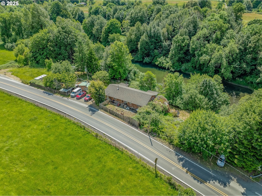
46760 Highway 242 Myrtle Point, OR 97458
Estimated payment $1,573/month
Highlights
- River Front
- Wood Burning Stove
- Private Yard
- Custom Home
- Seasonal View
- No HOA
About This Home
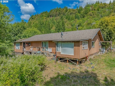
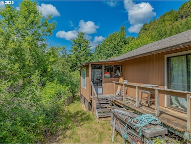
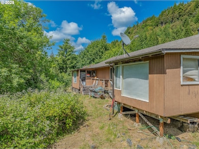
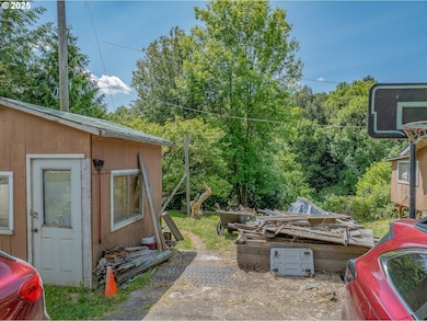
1.3 Acres with South Fork River front come located between the small logging town of Powers and Myrtle Point adjacent to the Gaylord Bridge, this 3-bedroom, 2-bath home sits on 1.3 level acres with mature fruit trees, a fenced yard, and peaceful water views. The property includes a storage shed, room for gardens or animals, and direct river access for fishing, kayaking, or just enjoying nature. Peaceful setting perfect for anyone looking to create a custom retreat in a prime location. With some TLC, this could be the riverside dream you’ve been waiting for!
Listing Agent
Pacific Properties Brokerage Phone: 541-297-5481 License #200604239 Listed on: 06/06/2025
Home Details
Home Type
- Single Family
Est. Annual Taxes
- $1,340
Year Built
- Built in 1969
Lot Details
- 1.39 Acre Lot
- River Front
- Poultry Coop
- Fenced
- Sloped Lot
- Private Yard
- Property is zoned EFU
Home Design
- Custom Home
- Block Foundation
- Composition Roof
- Plywood Siding Panel T1-11
Interior Spaces
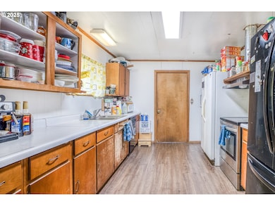
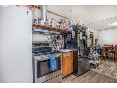
- 1,740 Sq Ft Home
- 1-Story Property
- Wood Burning Stove
- Wood Burning Fireplace
- Vinyl Clad Windows
- Family Room
- Living Room
- Dining Room
- First Floor Utility Room
- Laundry Room
- Seasonal Views
- Crawl Space
- Free-Standing Range
Bedrooms and Bathrooms
- 3 Bedrooms
- 2 Full Bathrooms
Parking
- Detached Garage
- Driveway
- Off-Street Parking
Accessible Home Design
- Accessibility Features
- Level Entry For Accessibility
Outdoor Features
- Shed
Schools
- Myrtle Crest Elementary School
- Myrtle Point Middle School
- Myrtle Point High School
Utilities
- No Cooling
- Heating System Uses Wood
- Well
- Electric Water Heater
- Septic Tank
- High Speed Internet
Community Details
- No Home Owners Association
Listing and Financial Details
- Assessor Parcel Number 1311000
Map
Home Values in the Area
Average Home Value in this Area
Tax History
| Year | Tax Paid | Tax Assessment Tax Assessment Total Assessment is a certain percentage of the fair market value that is determined by local assessors to be the total taxable value of land and additions on the property. | Land | Improvement |
|---|---|---|---|---|
| 2024 | $1,340 | $144,860 | -- | -- |
| 2023 | $1,262 | $140,650 | $0 | $0 |
| 2022 | $1,258 | $136,560 | $0 | $0 |
| 2021 | $1,232 | $132,590 | $0 | $0 |
| 2020 | $1,201 | $132,590 | $0 | $0 |
| 2019 | $1,136 | $124,990 | $0 | $0 |
| 2018 | $1,108 | $121,350 | $0 | $0 |
| 2017 | $1,084 | $117,820 | $0 | $0 |
| 2016 | $1,056 | $114,390 | $0 | $0 |
| 2015 | $997 | $111,060 | $0 | $0 |
| 2014 | $997 | $107,830 | $0 | $0 |
Property History
| Date | Event | Price | List to Sale | Price per Sq Ft |
|---|---|---|---|---|
| 10/01/2025 10/01/25 | Price Changed | $279,000 | 0.0% | $160 / Sq Ft |
| 10/01/2025 10/01/25 | For Sale | $279,000 | -6.7% | $160 / Sq Ft |
| 10/01/2025 10/01/25 | Off Market | $299,000 | -- | -- |
| 09/06/2025 09/06/25 | Price Changed | $299,000 | -8.0% | $172 / Sq Ft |
| 08/06/2025 08/06/25 | Price Changed | $325,000 | -6.9% | $187 / Sq Ft |
| 06/06/2025 06/06/25 | For Sale | $349,000 | -- | $201 / Sq Ft |
Purchase History
| Date | Type | Sale Price | Title Company |
|---|---|---|---|
| Warranty Deed | $183,500 | Ticor Title Company Of Or | |
| Quit Claim Deed | -- | None Available | |
| Interfamily Deed Transfer | -- | None Available |
Mortgage History
| Date | Status | Loan Amount | Loan Type |
|---|---|---|---|
| Open | $165,150 | New Conventional |
Source: Regional Multiple Listing Service (RMLS)
MLS Number: 451969371
APN: 1001311000
Disclaimer: Certain information contained herein is derived from information provided by parties other than Homes.com. All information provided is deemed reliable, but is not guaranteed to be accurate and should be independently verified.
![]() The content relating to real estate for sale on this web site comes in part from the IDX program of the RMLS™ of Portland, Oregon. Real estate listings held by brokerage firms other than Ten-X are marked with the RMLS™ logo, and detailed information about these properties includes the names of the listing brokers. Listing content is copyright © 2025 RMLS™, Portland, Oregon. Some properties which appear for sale on this web site may subsequently have sold or may no longer be available. All information provided is deemed reliable but is not guaranteed and should be independently verified.
The content relating to real estate for sale on this web site comes in part from the IDX program of the RMLS™ of Portland, Oregon. Real estate listings held by brokerage firms other than Ten-X are marked with the RMLS™ logo, and detailed information about these properties includes the names of the listing brokers. Listing content is copyright © 2025 RMLS™, Portland, Oregon. Some properties which appear for sale on this web site may subsequently have sold or may no longer be available. All information provided is deemed reliable but is not guaranteed and should be independently verified.
- 46393 Highway 242
- 46255 Highway 242
- 45275 Highway 242
- 51014 Dement Creek Rd
- 1010 H Ave
- 110 E Birch St
- 889 H Ave
- 51372 Old Broadbent Rd
- 130 E Date St
- 151 E Date St
- 15779 Oregon 42
- 815 E Ave
- 631 2nd Ave
- 510 Fir St
- 141 Poplar St
- 432 2nd Ave
- 380 3rd Ave
- 45651 Johnson Mountain Rd
- 0 Johnson Mt Rd Unit 600 168667991
- 51256 Salmon Gulch Rd
