


46817 70th St E Lancaster, CA 93535
About This Lot
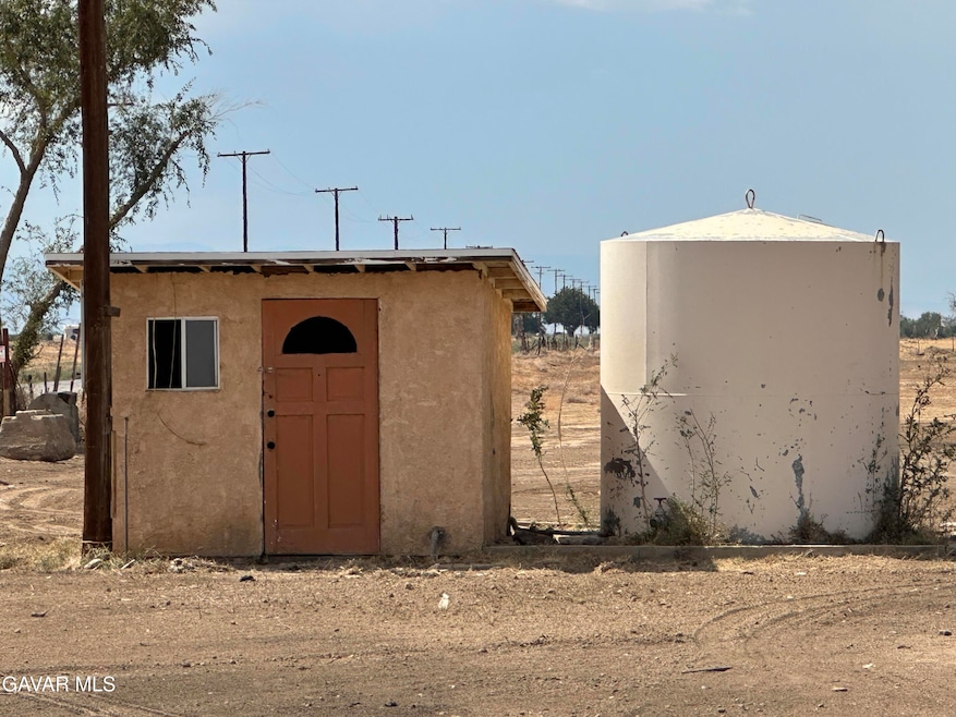
FIRST TIME ON THE MARKET IN ALMOST ONE HALF CENTURY!!! RARE PROPERTY!!! CORNER LOCATION, PAVED ROADS at street. Zoned LCA21*! Situated on almost 18 FLAT acres, corner lot with utilities! Start a farming business and grow crops? Originally a 'duplex' as shown on tax records, (two separate dwellings) with combined 4 bedrooms, 2 baths that have since BURNT DOWN, earlier this year in July 2025! Buyer to investigate to check with the county to see what is entailed with re-building, if they wish to do that. Per seller, deep agricultural well. Electricity to property. Decades ago, it was an alfalfa farm. Nothing similar currently on the market! The possibilities are endless! Buyer to do their own investigations. This property is sold strictly AS IS.
Property Details
Property Type
- Land
Lot Details
- 17.84 Acre Lot
- Property is zoned LCA21*
Utilities
- Private Water Source
- Well
- Septic Tank
Community Details
- No Home Owners Association
Listing and Financial Details
- Assessor Parcel Number 3302-023-013
Map
Tax History
| Year | Tax Paid | Tax Assessment Tax Assessment Total Assessment is a certain percentage of the fair market value that is determined by local assessors to be the total taxable value of land and additions on the property. | Land | Improvement |
|---|---|---|---|---|
| 2025 | $2,235 | $157,193 | $94,228 | $62,965 |
| 2024 | $2,235 | $154,112 | $92,381 | $61,731 |
| 2023 | $1,991 | $151,091 | $90,570 | $60,521 |
| 2022 | $2,000 | $148,130 | $88,795 | $59,335 |
| 2021 | $1,988 | $145,226 | $87,054 | $58,172 |
| 2020 | $1,956 | $143,738 | $86,162 | $57,576 |
| 2019 | $1,936 | $140,921 | $84,473 | $56,448 |
| 2018 | $1,938 | $138,159 | $82,817 | $55,342 |
| 2016 | $1,829 | $132,796 | $79,602 | $53,194 |
| 2015 | $1,800 | $130,802 | $78,407 | $52,395 |
| 2014 | $1,848 | $128,241 | $76,872 | $51,369 |
Property History
| Date | Event | Price | List to Sale | Price per Sq Ft | Prior Sale |
|---|---|---|---|---|---|
| 12/19/2025 12/19/25 | Sold | $180,000 | -10.0% | $108 / Sq Ft | View Prior Sale |
| 10/02/2025 10/02/25 | Price Changed | $199,900 | -33.3% | $120 / Sq Ft | |
| 09/12/2025 09/12/25 | For Sale | $299,900 | -- | $180 / Sq Ft |
Purchase History
| Date | Type | Sale Price | Title Company |
|---|---|---|---|
| Grant Deed | $180,000 | First American Title Company | |
| Interfamily Deed Transfer | -- | -- | |
| Interfamily Deed Transfer | -- | -- |
Source: Greater Antelope Valley Association of REALTORS®
MLS Number: 25007319
APN: 3302-023-013
Disclaimer: Certain information contained herein is derived from information provided by parties other than Homes.com. All information provided is deemed reliable, but is not guaranteed to be accurate and should be independently verified.
![]() IDX information is provided exclusively for personal, non-commercial use, and may not be used for any purpose other than to identify prospective properties consumers may be interested in purchasing.
IDX information is provided exclusively for personal, non-commercial use, and may not be used for any purpose other than to identify prospective properties consumers may be interested in purchasing.
Information is deemed reliable but not guaranteed.
- 14400 E Avenue F 8
- 155 E Avenue F 8
- 15500 E Avenue F 8
- 7263 E Avenue F 8
- 80 80th St E
- 46318 80th St E
- 0 80th St E
- 0 E 79th Vic Avenue G2 St
- 0 65th St East & Ave G-12 Unit 24005778
- 0 62nd Str E Avenue G-6
- 0 E Ave G4 Unit 25004075
- 0 Vac/Vic Avenue Unit L/165 Ste
- 6555 E Avenue H
- 0 81st Street East & Avenue G4
- 81st Street East & Avenue G-4
- 0 Ave A2 Vic 81 Stw Unit 238705
- 46200 60th St E
- 0 63rd St E
- 0 Vic Ave G4 85 Ste
- 0 E Vic Ave F8 85 Stw Unit 238728

Ask me questions while you tour the home.