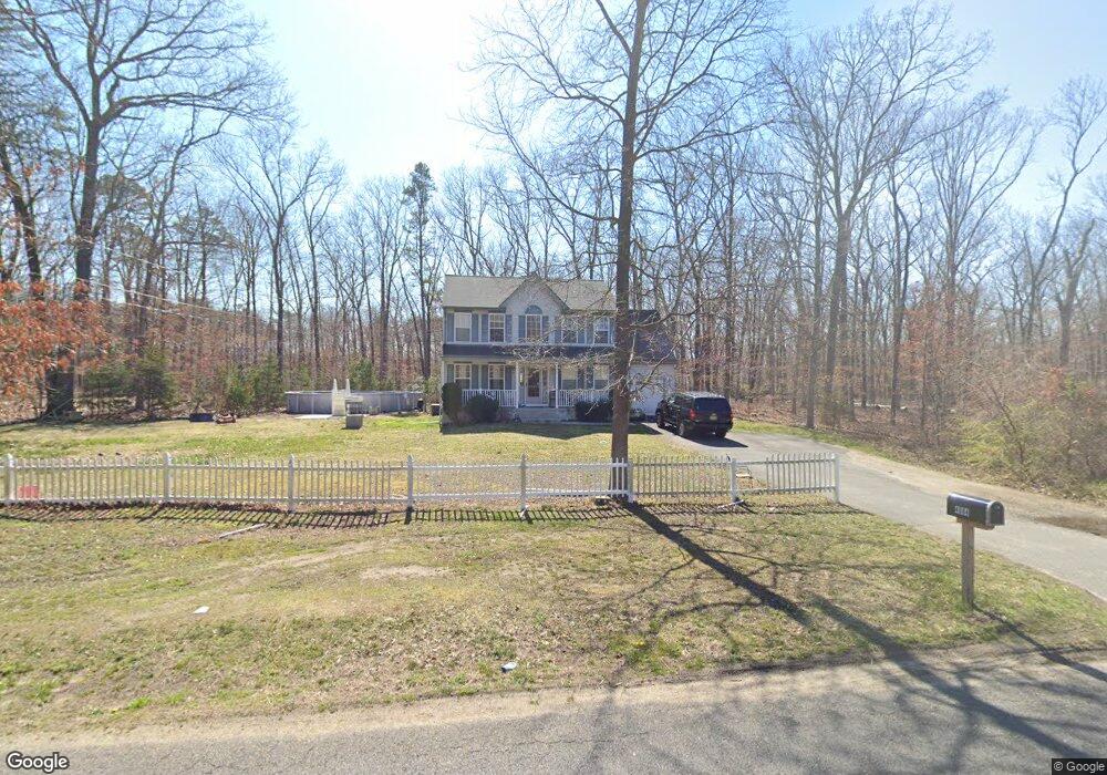
4684 Lake Rd Newfield, NJ 08344
Franklin Township NeighborhoodEstimated Value: $328,954 - $563,000
--
Bed
--
Bath
1,752
Sq Ft
$272/Sq Ft
Est. Value
About This Home
This home is located at 4684 Lake Rd, Newfield, NJ 08344 and is currently estimated at $477,239, approximately $272 per square foot. 4684 Lake Rd is a home located in Gloucester County with nearby schools including Delsea Regional Middle School, Delsea Regional High School, and Edgarton Christian Academy.
Ownership History
Date
Name
Owned For
Owner Type
Purchase Details
Closed on
Apr 6, 2021
Sold by
Repp Tina
Bought by
Repp Tina and Repp Darrin
Current Estimated Value
Purchase Details
Closed on
Aug 23, 2005
Sold by
Coal Builders Llc
Bought by
Repp Tina
Home Financials for this Owner
Home Financials are based on the most recent Mortgage that was taken out on this home.
Original Mortgage
$215,920
Outstanding Balance
$121,180
Interest Rate
6.74%
Mortgage Type
Fannie Mae Freddie Mac
Estimated Equity
$356,059
Purchase Details
Closed on
Jan 18, 2005
Sold by
Colucci Gerald B
Bought by
Coal Builders Llc
Home Financials for this Owner
Home Financials are based on the most recent Mortgage that was taken out on this home.
Original Mortgage
$60,000
Interest Rate
5.71%
Mortgage Type
Seller Take Back
Create a Home Valuation Report for This Property
The Home Valuation Report is an in-depth analysis detailing your home's value as well as a comparison with similar homes in the area
Home Values in the Area
Average Home Value in this Area
Purchase History
| Date | Buyer | Sale Price | Title Company |
|---|---|---|---|
| Repp Tina | -- | None Available | |
| Repp Tina | $269,900 | Continental Abstract | |
| Coal Builders Llc | $60,000 | Homestead Title Agency Via E |
Source: Public Records
Mortgage History
| Date | Status | Borrower | Loan Amount |
|---|---|---|---|
| Open | Repp Tina | $215,920 | |
| Previous Owner | Coal Builders Llc | $60,000 |
Source: Public Records
Tax History Compared to Growth
Tax History
| Year | Tax Paid | Tax Assessment Tax Assessment Total Assessment is a certain percentage of the fair market value that is determined by local assessors to be the total taxable value of land and additions on the property. | Land | Improvement |
|---|---|---|---|---|
| 2025 | $7,739 | $201,800 | $28,100 | $173,700 |
| 2024 | $7,557 | $201,800 | $28,100 | $173,700 |
| 2023 | $7,557 | $201,800 | $28,100 | $173,700 |
| 2022 | $7,356 | $201,800 | $28,100 | $173,700 |
| 2021 | $7,235 | $201,800 | $28,100 | $173,700 |
| 2020 | $7,142 | $201,800 | $28,100 | $173,700 |
| 2019 | $7,047 | $201,800 | $28,100 | $173,700 |
| 2018 | $6,944 | $201,800 | $28,100 | $173,700 |
| 2017 | $6,817 | $201,800 | $28,100 | $173,700 |
| 2016 | $6,791 | $201,800 | $28,100 | $173,700 |
| 2015 | $6,514 | $201,800 | $28,100 | $173,700 |
| 2014 | $6,262 | $201,800 | $28,100 | $173,700 |
Source: Public Records
Map
Nearby Homes
- 14 Sandy Dr
- 4529 Robin Rd
- 1245 Old Lake Rd
- 1301 Old Lake Rd
- 213 Church St
- 0 Helena St
- 4191 Lake Rd Unit 5
- 214 Rosemont Ave
- 9 Southeast Blvd
- 2550 Harding Hwy
- 0 Madison Ave & Fawn Dr Unit NJGL2026814
- 0 Madison Ave & Fawn Dr Unit NJGL2026098
- 0 Rt 40 & Rosemont
- 4111 N Delsea Dr Unit 3
- 322 Madison Ave
- 1701 West Blvd
- 108 U S 40
- 3485 Harding Hwy
- 1681-95 Harding Hwy
- 478 480 U S 40