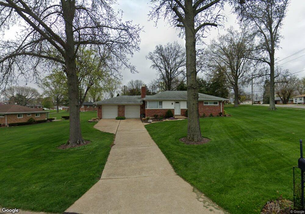
4684 Venarde Dr Saint Louis, MO 63128
Estimated Value: $237,977 - $313,000
3
Beds
1
Bath
1,040
Sq Ft
$268/Sq Ft
Est. Value
About This Home
This home is located at 4684 Venarde Dr, Saint Louis, MO 63128 and is currently estimated at $278,744, approximately $268 per square foot. 4684 Venarde Dr is a home located in St. Louis County with nearby schools including Kennerly Elementary School, Sperreng Middle School, and Lindbergh High School.
Ownership History
Date
Name
Owned For
Owner Type
Purchase Details
Closed on
Jul 19, 2013
Sold by
Pontious Larry M and Pontious Elaine A
Bought by
Lee James
Current Estimated Value
Home Financials for this Owner
Home Financials are based on the most recent Mortgage that was taken out on this home.
Original Mortgage
$143,355
Outstanding Balance
$106,324
Interest Rate
4.4%
Mortgage Type
FHA
Estimated Equity
$172,420
Purchase Details
Closed on
Oct 21, 2004
Sold by
Koenig Earl J
Bought by
Pontious Larry M and Pontious Eliane A
Create a Home Valuation Report for This Property
The Home Valuation Report is an in-depth analysis detailing your home's value as well as a comparison with similar homes in the area
Home Values in the Area
Average Home Value in this Area
Purchase History
| Date | Buyer | Sale Price | Title Company |
|---|---|---|---|
| Lee James | $746,000 | Title Partners Agency Llc | |
| Pontious Larry M | $156,000 | -- |
Source: Public Records
Mortgage History
| Date | Status | Borrower | Loan Amount |
|---|---|---|---|
| Open | Lee James | $143,355 |
Source: Public Records
Tax History
| Year | Tax Paid | Tax Assessment Tax Assessment Total Assessment is a certain percentage of the fair market value that is determined by local assessors to be the total taxable value of land and additions on the property. | Land | Improvement |
|---|---|---|---|---|
| 2025 | $2,439 | $41,690 | $16,740 | $24,950 |
| 2024 | $2,439 | $37,330 | $18,580 | $18,750 |
| 2023 | $2,433 | $37,330 | $18,580 | $18,750 |
| 2022 | $2,542 | $37,450 | $18,580 | $18,870 |
| 2021 | $2,452 | $37,450 | $18,580 | $18,870 |
| 2020 | $2,110 | $31,030 | $16,110 | $14,920 |
| 2019 | $2,104 | $31,030 | $16,110 | $14,920 |
| 2018 | $1,971 | $26,420 | $9,980 | $16,440 |
| 2017 | $1,950 | $26,420 | $9,980 | $16,440 |
| 2016 | $1,977 | $25,440 | $8,990 | $16,450 |
Source: Public Records
Map
Nearby Homes
- 4650 Venarde Dr
- 4767 Towne South Rd
- 4852 Danebury Dr
- 4918 Caribee Dr
- 4764 Brawley Ct
- 4603 Mattis Rd
- 5108 Kennerly Place Dr Unit 7A
- 12430 Somerset Place Dr
- 5117 Melitta Dr
- 4931 Theiss Rd
- 4447 Gemini Dr
- 9836 Charwick Dr
- 4753 Titan Ct
- 12586 Chardin Place Unit 4
- 10022 Chardin Way Unit 3
- 4744 Tonga Dr
- 4525 Eli Dr Unit F
- 4525 Eli Dr Unit D
- 4501 Eli Dr Unit K
- 4442 Patston Dr
- 4674 Venarde Dr
- 4833 Mattis Rd
- 4836 Mattis Rd
- 4666 de Chantal Dr
- 4830 Mattis Rd
- 4691 Venarde Dr
- 4844 Mattis Rd
- 4824 Mattis Rd
- 4681 Venarde Dr
- 4819 Mattis Rd
- 4660 Venarde Dr
- 4671 Venarde Dr
- 4658 de Chantal Dr
- 4811 Mattis Rd
- 4852 Mattis Rd
- 4651 de Chantal Dr
- 4680 Towne South Rd
- 4672 Towne South Rd
- 4666 Towne South Rd
- 4704 Towne South Rd