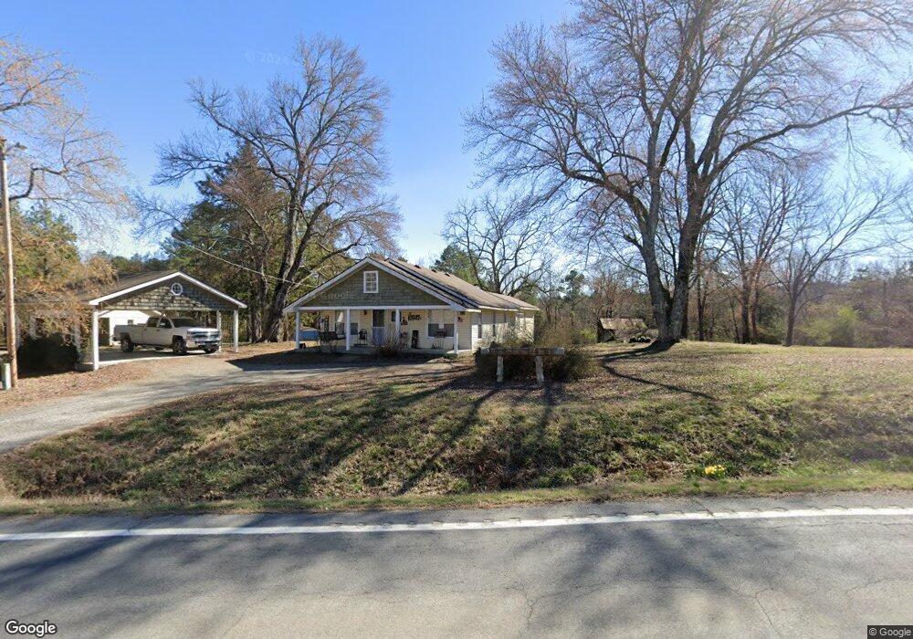
4691 Highway 9 W Clinton, AR 72031
Estimated Value: $165,818 - $404,000
--
Bed
2
Baths
1,400
Sq Ft
$175/Sq Ft
Est. Value
About This Home
This home is located at 4691 Highway 9 W, Clinton, AR 72031 and is currently estimated at $244,955, approximately $174 per square foot. 4691 Highway 9 W is a home located in Van Buren County with nearby schools including Clinton Elementary School, Clinton Junior High School, and Clinton High School.
Ownership History
Date
Name
Owned For
Owner Type
Purchase Details
Closed on
Feb 19, 2019
Sold by
Kniola Deanna J and Kniola Kenneth E
Bought by
Smith Bobby
Current Estimated Value
Home Financials for this Owner
Home Financials are based on the most recent Mortgage that was taken out on this home.
Original Mortgage
$101,583
Interest Rate
4.4%
Mortgage Type
Commercial
Purchase Details
Closed on
Sep 24, 2001
Bought by
Blair
Purchase Details
Closed on
Aug 9, 1995
Bought by
Helm
Create a Home Valuation Report for This Property
The Home Valuation Report is an in-depth analysis detailing your home's value as well as a comparison with similar homes in the area
Home Values in the Area
Average Home Value in this Area
Purchase History
| Date | Buyer | Sale Price | Title Company |
|---|---|---|---|
| Smith Bobby | $200,000 | Cannaday Abstract | |
| Blair | -- | -- | |
| Helm | -- | -- |
Source: Public Records
Mortgage History
| Date | Status | Borrower | Loan Amount |
|---|---|---|---|
| Closed | Smith Bobby | $101,583 |
Source: Public Records
Tax History Compared to Growth
Tax History
| Year | Tax Paid | Tax Assessment Tax Assessment Total Assessment is a certain percentage of the fair market value that is determined by local assessors to be the total taxable value of land and additions on the property. | Land | Improvement |
|---|---|---|---|---|
| 2024 | $603 | $13,680 | $820 | $12,860 |
| 2023 | $652 | $13,680 | $820 | $12,860 |
| 2022 | $652 | $13,680 | $820 | $12,860 |
| 2021 | $652 | $13,680 | $820 | $12,860 |
| 2020 | $652 | $13,680 | $820 | $12,860 |
| 2019 | $562 | $12,110 | $880 | $11,230 |
| 2018 | $176 | $12,110 | $880 | $11,230 |
| 2017 | $355 | $9,420 | $880 | $8,540 |
| 2015 | -- | $8,170 | $920 | $7,250 |
| 2014 | -- | $8,170 | $920 | $7,250 |
| 2013 | -- | $8,170 | $920 | $7,250 |
Source: Public Records
Map
Nearby Homes
- 433 Cody Dr
- 0 Round Spring Rd Unit 25030586
- Tract 10 Harmony Mountain Rd
- Tract 8 Harmony Mountain Rd
- Tract 6 Harmony Mountain Rd
- Tract 5 Harmony Mountain Rd
- Tract 3 Harmony Mountain Rd
- Tract 2 Harmony Mountain Rd
- Tract 1 Harmony Mountain Rd
- 625 Bens Cir
- 441 Holly Leaf Rd
- Lot 13 Bens Cir
- 198 Rue Dr
- 6939 Highway 336 W
- 7429 Hwy 336 W
- 313 Bobbits Ln
- 504 Boar Rd
- 6880 Arkansas 9
- 163 Junior Cir
- 6846 Highway 9
- 4682 Arkansas 9
- 4834 Highway 9 W
- 4374 Highway 9 W
- 4378 Highway 9 W
- 0 Hwy 9 W Unit 16012762
- 0 Hwy 9 W Unit 20029478
- 0 Hwy 9 W Unit 20015799
- 4834 Hwy 9 W
- 4940 Highway 9 W
- 4933 Highway 9 W
- 4972 Highway 9 W
- 0 Hill Point Rd Unit 24042371
- 0 Hill Point Rd Unit 18000735
- 1173 Hill Point Rd
- 5052 Highway 9 W
- 178 Round Spring Rd
- 1087 Hill Point Rd
- 989 Hill Point Rd
- 1049 Hill Point Rd
- 524 Newport Rd