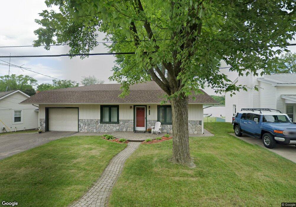
4692 Rockcroft Blvd Clarkston, MI 48346
Estimated Value: $287,000 - $351,000
3
Beds
2
Baths
1,152
Sq Ft
$281/Sq Ft
Est. Value
About This Home
This home is located at 4692 Rockcroft Blvd, Clarkston, MI 48346 and is currently estimated at $323,500, approximately $280 per square foot. 4692 Rockcroft Blvd is a home located in Oakland County with nearby schools including Schoolcraft Elementary School, Waterford Kettering High School, and Mason Middle School.
Ownership History
Date
Name
Owned For
Owner Type
Purchase Details
Closed on
Aug 25, 2016
Sold by
Methner William John and Methner Marie Beth
Bought by
Townsend Dennis E and Townsend Angela R
Current Estimated Value
Home Financials for this Owner
Home Financials are based on the most recent Mortgage that was taken out on this home.
Original Mortgage
$179,550
Outstanding Balance
$142,340
Interest Rate
3.45%
Mortgage Type
New Conventional
Estimated Equity
$181,160
Purchase Details
Closed on
Nov 10, 2004
Sold by
Methner William John
Bought by
Methner William John and Methner Marie Beth
Create a Home Valuation Report for This Property
The Home Valuation Report is an in-depth analysis detailing your home's value as well as a comparison with similar homes in the area
Home Values in the Area
Average Home Value in this Area
Purchase History
| Date | Buyer | Sale Price | Title Company |
|---|---|---|---|
| Townsend Dennis E | $189,000 | Seaver Title Agency | |
| Methner William John | -- | -- |
Source: Public Records
Mortgage History
| Date | Status | Borrower | Loan Amount |
|---|---|---|---|
| Open | Townsend Dennis E | $179,550 |
Source: Public Records
Tax History Compared to Growth
Tax History
| Year | Tax Paid | Tax Assessment Tax Assessment Total Assessment is a certain percentage of the fair market value that is determined by local assessors to be the total taxable value of land and additions on the property. | Land | Improvement |
|---|---|---|---|---|
| 2025 | $3,499 | $169,500 | $63,300 | $106,200 |
| 2024 | $2,321 | $146,200 | $58,800 | $87,400 |
| 2023 | $3,141 | $134,200 | $55,300 | $78,900 |
| 2022 | $3,141 | $123,300 | $48,100 | $75,200 |
| 2021 | $3,143 | $121,100 | $43,900 | $77,200 |
| 2020 | $2,026 | $98,000 | $21,800 | $76,200 |
| 2018 | $3,022 | $90,800 | $21,700 | $69,100 |
| 2015 | -- | $68,800 | $0 | $0 |
| 2014 | -- | $60,400 | $0 | $0 |
| 2011 | -- | $50,800 | $0 | $0 |
Source: Public Records
Map
Nearby Homes
- 5721 Corunna Ave
- 0 Harding Ave Harding Ave
- 4886 Harding Ave
- 000 Dixie Hwy
- 5826 Andersonville Rd
- 4281 Marcus Rd
- 6624 Wellesley Terrace
- 000 Waterloo St
- 4125 Rural St
- 3912 Cambrook Ln
- 6440 Andersonville Rd
- 5069 Timberway Trail
- 6031 Southward Ave
- 5336 Forest Ridge Dr Unit 55
- 5333 Waterford Rd
- 6522 Saline Dr
- 6570 Saline Dr
- 5183 Eagle Lake Dr
- 6533 Cloverton Dr
- 3947 Percy King Rd
- 4682 Rockcroft Blvd
- 4704 Rockcroft Blvd
- 4664 Rockcroft Blvd
- 4716 Rockcroft Blvd
- 4669 Rockcroft Blvd
- 4654 Rockcroft Blvd
- 5882 Dixie Hwy
- 5882 Dixie Hwy
- 5882 Dixie Hwy Unit 2
- 5882 Dixie Hwy Unit 3
- 5882 Dixie Hwy Unit 1
- 5886 Dixie Hwy
- 5886 Dixie Hwy
- 4750 Rockcroft Blvd
- 4644 Rockcroft Blvd
- 5888 Dixie Hwy
- 4634 Rockcroft Blvd
- 5880 Dixie Hwy
- 4641 Rockcroft Blvd
- 4770 Rockcroft Blvd