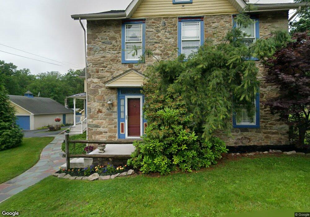
4698 Maple Dr Walnutport, PA 18088
Estimated Value: $240,000 - $355,000
3
Beds
2
Baths
1,344
Sq Ft
$218/Sq Ft
Est. Value
About This Home
This home is located at 4698 Maple Dr, Walnutport, PA 18088 and is currently estimated at $292,752, approximately $217 per square foot. 4698 Maple Dr is a home located in Northampton County with nearby schools including Lehigh Elementary School, Northampton Area Middle School, and Northampton Area High School.
Ownership History
Date
Name
Owned For
Owner Type
Purchase Details
Closed on
Sep 27, 2022
Sold by
Fronti and Lisa
Bought by
Fronti Anthony M
Current Estimated Value
Purchase Details
Closed on
May 20, 2021
Sold by
Amico Steven S and Estate Of Sebastian J Amico
Bought by
Fronti Joseph and Fronti Lisa
Purchase Details
Closed on
Oct 24, 2018
Sold by
Becker Carl D and Becker Linda K
Bought by
Amico Sebastian J
Home Financials for this Owner
Home Financials are based on the most recent Mortgage that was taken out on this home.
Original Mortgage
$87,500
Interest Rate
5%
Mortgage Type
Seller Take Back
Purchase Details
Closed on
Nov 1, 1996
Bought by
Becker Carl D and Becker Linda K
Create a Home Valuation Report for This Property
The Home Valuation Report is an in-depth analysis detailing your home's value as well as a comparison with similar homes in the area
Home Values in the Area
Average Home Value in this Area
Purchase History
| Date | Buyer | Sale Price | Title Company |
|---|---|---|---|
| Fronti Anthony M | -- | -- | |
| Fronti Joseph | $151,000 | Traditional Abstract Llc | |
| Amico Sebastian J | -- | Advanced Abstract Inc | |
| Becker Carl D | $50,000 | -- |
Source: Public Records
Mortgage History
| Date | Status | Borrower | Loan Amount |
|---|---|---|---|
| Previous Owner | Amico Sebastian J | $87,500 |
Source: Public Records
Tax History
| Year | Tax Paid | Tax Assessment Tax Assessment Total Assessment is a certain percentage of the fair market value that is determined by local assessors to be the total taxable value of land and additions on the property. | Land | Improvement |
|---|---|---|---|---|
| 2025 | $591 | $54,700 | $21,700 | $33,000 |
| 2024 | $4,021 | $54,700 | $21,700 | $33,000 |
| 2023 | $3,690 | $51,100 | $21,700 | $29,400 |
| 2022 | $3,690 | $51,100 | $21,700 | $29,400 |
| 2021 | $3,699 | $51,100 | $21,700 | $29,400 |
| 2020 | $3,699 | $51,100 | $21,700 | $29,400 |
| 2019 | $3,645 | $51,100 | $21,700 | $29,400 |
| 2018 | $3,591 | $51,100 | $21,700 | $29,400 |
| 2017 | $3,513 | $51,100 | $21,700 | $29,400 |
| 2016 | -- | $51,100 | $21,700 | $29,400 |
| 2015 | -- | $51,100 | $21,700 | $29,400 |
| 2014 | -- | $51,100 | $21,700 | $29,400 |
Source: Public Records
Map
Nearby Homes
- 530 Old Main St
- 616 Almond Rd
- 4586 W Mountain View Dr
- 319 Washington St
- 321 Washington St
- 35 Linda Dr
- 744 Williams Ave
- 84 Linda Dr
- 464 Long Lane Rd
- 448 Long Lane Rd
- 47 Cherry St
- 582 Ironwood Rd
- 44 N Canal St
- 37 Stacey Dr
- 4849 Lehigh Dr Unit 27
- 515 E Church St
- 207 Chestnut St
- 206 Hill St
- 422 Center St
- 1225 Quince Rd