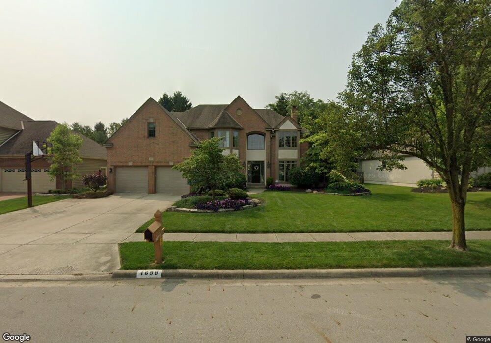
4699 Glanstonbury Dr Hilliard, OH 43026
Estimated Value: $600,000 - $672,000
4
Beds
3
Baths
3,088
Sq Ft
$207/Sq Ft
Est. Value
About This Home
This home is located at 4699 Glanstonbury Dr, Hilliard, OH 43026 and is currently estimated at $637,676, approximately $206 per square foot. 4699 Glanstonbury Dr is a home located in Franklin County with nearby schools including Hilliard Tharp Sixth Grade Elementary School, Britton Elementary School, and Hilliard Weaver Middle School.
Ownership History
Date
Name
Owned For
Owner Type
Purchase Details
Closed on
Jul 24, 2010
Sold by
Powell Robert W
Bought by
Powell Loretta Osullivan
Current Estimated Value
Home Financials for this Owner
Home Financials are based on the most recent Mortgage that was taken out on this home.
Original Mortgage
$294,400
Interest Rate
4.7%
Mortgage Type
New Conventional
Purchase Details
Closed on
Apr 6, 1994
Create a Home Valuation Report for This Property
The Home Valuation Report is an in-depth analysis detailing your home's value as well as a comparison with similar homes in the area
Home Values in the Area
Average Home Value in this Area
Purchase History
| Date | Buyer | Sale Price | Title Company |
|---|---|---|---|
| Powell Loretta Osullivan | -- | Independent | |
| -- | $40,000 | -- |
Source: Public Records
Mortgage History
| Date | Status | Borrower | Loan Amount |
|---|---|---|---|
| Closed | Powell Loretta Osullivan | $294,400 |
Source: Public Records
Tax History Compared to Growth
Tax History
| Year | Tax Paid | Tax Assessment Tax Assessment Total Assessment is a certain percentage of the fair market value that is determined by local assessors to be the total taxable value of land and additions on the property. | Land | Improvement |
|---|---|---|---|---|
| 2024 | $13,745 | $205,210 | $47,880 | $157,330 |
| 2023 | $11,192 | $205,205 | $47,880 | $157,325 |
| 2022 | $10,367 | $151,280 | $30,140 | $121,140 |
| 2021 | $10,361 | $151,280 | $30,140 | $121,140 |
| 2020 | $10,335 | $151,280 | $30,140 | $121,140 |
| 2019 | $10,440 | $130,070 | $26,220 | $103,850 |
| 2018 | $9,999 | $130,070 | $26,220 | $103,850 |
| 2017 | $10,280 | $130,070 | $26,220 | $103,850 |
| 2016 | $10,159 | $117,600 | $22,470 | $95,130 |
| 2015 | $9,594 | $117,600 | $22,470 | $95,130 |
| 2014 | $9,611 | $117,600 | $22,470 | $95,130 |
| 2013 | $4,645 | $112,000 | $21,385 | $90,615 |
Source: Public Records
Map
Nearby Homes
- 4704 Carrington Way
- 4984 Britton Farms Dr
- 4860 Britton Farms Dr
- 0 Davidson Rd
- 4735 Clubpark Dr Unit 11
- 4706 Clubpark Dr Unit 17
- 4471 Addison Ln S
- 0 Hickory Chase Way
- 4473 Addison Ln S
- Wexford with Finished Lower Level Plan at Davidson Towns
- 0 Riggins Rd
- 4253 Davidson Rd
- 4813 Ashleigh Dr
- 4865 Ashleigh Dr
- 4908 Ashleigh Dr Unit 4908
- 4801 Rays Cir SW Unit 4801
- 5017 Calais Dr Unit 5017
- 3940 Rennes Dr
- 3914 Rue de Brittany Unit 3914
- 3896 Rue de Brittany
- 4713 Glanstonbury Dr
- 4689 Glanstonbury Dr
- 4689 Glastonbury Dr
- 4723 Glastonbury Dr
- 4723 Glanstonbury Dr
- 4652 Huntwicke Dr
- 4679 Glanstonbury Dr
- 4994 Devoncroft Ct
- 4994 Devencroft Ct
- 4648 Huntwicke Dr
- 4658 Huntwicke Dr
- 4995 Devencroft Ct
- 4680 Glanstonbury Dr
- 4733 Glanstonbury Dr
- 4730 Glanstonbury Dr
- 4662 Huntwicke Dr
- 5004 Devencroft Ct
- 4941 Britton Farms Dr
- 4953 Britton Farms Dr
- 4739 Glanstonbury Dr