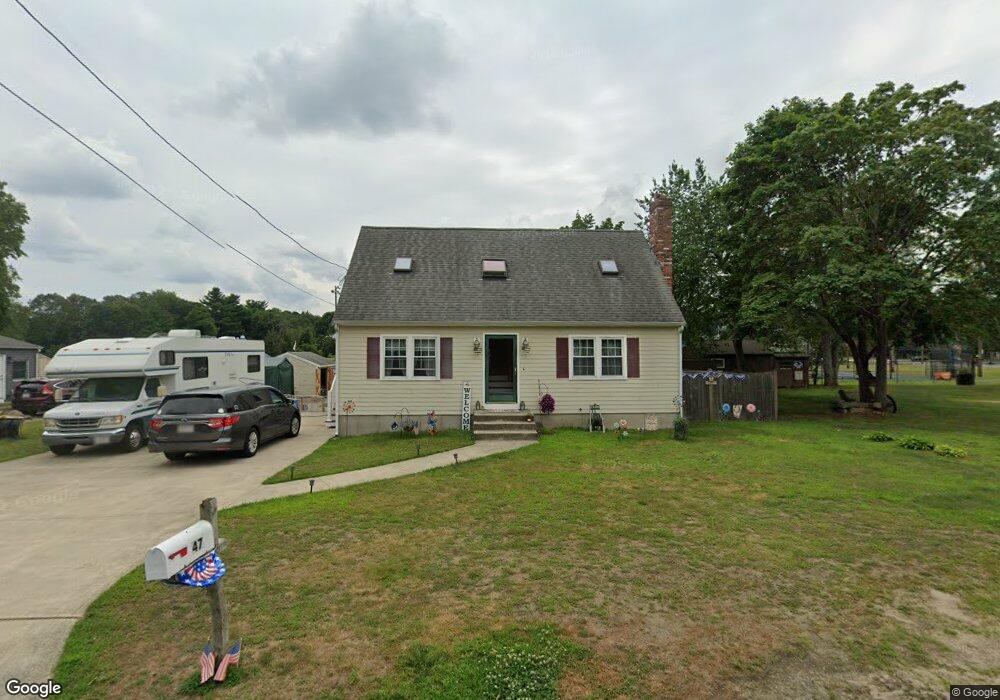
47 Adamsdale Ave Attleboro, MA 02703
Estimated Value: $488,280 - $585,000
2
Beds
2
Baths
1,408
Sq Ft
$377/Sq Ft
Est. Value
About This Home
This home is located at 47 Adamsdale Ave, Attleboro, MA 02703 and is currently estimated at $530,820, approximately $377 per square foot. 47 Adamsdale Ave is a home located in Bristol County with nearby schools including Hill-Roberts Elementary School, Robert J. Coelho Middle School, and Attleboro High School.
Ownership History
Date
Name
Owned For
Owner Type
Purchase Details
Closed on
Oct 20, 1995
Sold by
Rogers Thoams W and Rogers Leah M
Bought by
Dean Peter P and Dean Rebecca L
Current Estimated Value
Purchase Details
Closed on
May 12, 1994
Sold by
Poulin Allan M and Poulin Betty J
Bought by
Rogers Thomas W and Rogers Leah M
Purchase Details
Closed on
Oct 2, 1987
Sold by
Mclaughlin and Dunn
Bought by
Poulin Allam B
Create a Home Valuation Report for This Property
The Home Valuation Report is an in-depth analysis detailing your home's value as well as a comparison with similar homes in the area
Home Values in the Area
Average Home Value in this Area
Purchase History
| Date | Buyer | Sale Price | Title Company |
|---|---|---|---|
| Dean Peter P | $135,000 | -- | |
| Rogers Thomas W | $133,700 | -- | |
| Poulin Allam B | $131,900 | -- |
Source: Public Records
Mortgage History
| Date | Status | Borrower | Loan Amount |
|---|---|---|---|
| Open | Poulin Allam B | $227,618 | |
| Closed | Poulin Allam B | $29,000 |
Source: Public Records
Tax History Compared to Growth
Tax History
| Year | Tax Paid | Tax Assessment Tax Assessment Total Assessment is a certain percentage of the fair market value that is determined by local assessors to be the total taxable value of land and additions on the property. | Land | Improvement |
|---|---|---|---|---|
| 2025 | $5,085 | $405,200 | $124,800 | $280,400 |
| 2024 | $4,906 | $385,400 | $124,800 | $260,600 |
| 2023 | $4,579 | $334,500 | $113,400 | $221,100 |
| 2022 | $4,318 | $298,800 | $108,100 | $190,700 |
| 2021 | $4,202 | $283,900 | $103,900 | $180,000 |
| 2020 | $4,010 | $275,400 | $100,900 | $174,500 |
| 2019 | $3,771 | $266,300 | $98,900 | $167,400 |
| 2018 | $3,575 | $241,200 | $96,000 | $145,200 |
| 2017 | $3,456 | $237,500 | $96,000 | $141,500 |
| 2016 | $3,355 | $226,400 | $94,200 | $132,200 |
| 2015 | $3,169 | $215,400 | $94,200 | $121,200 |
| 2014 | $3,090 | $208,100 | $89,800 | $118,300 |
Source: Public Records
Map
Nearby Homes
- 2 Gardner Ave
- 49 Gardner Ave
- 103 Hall Ave
- 12 Tyson Place
- 52 Curtis Ave
- 23 Magnolia St Unit 2
- 44 Buffington St
- 330 Brown St
- 171 Mendon Rd
- 58 Baltic St Unit 58
- 56 Baltic St Unit 56
- 18 Newton St
- 55 Leedham St Unit 2-6
- 6 Castle Rd
- 980 Newport Ave
- 511 Mendon Rd Unit 511
- 509 Mendon Rd Unit 509
- 50 Pullman Ave Unit A
- 50 Pullman Ave Unit B
- 500 Mendon Rd Unit 257
- 102 Adamsdale Ave
- 44 Adamsdale Ave
- 27 Adamsdale Ave
- 57 Adamsdale Ave
- 32 Adamsdale Ave
- 65 Adamsdale Ave
- 65 Adamsdale Ave Unit 2
- 64 Adamsdale Ave
- 66 Adamsdale Ave
- 47 Allen Ave
- 59 Allen Ave
- 28 Adamsdale Ave
- 61 Adamsdale Ave
- 65 Allen Ave
- 23 Adamsdale Ave
- 31 Allen Ave
- 74 Adamsdale Ave
- 39 Allen Ave
- 46 Allen Ave
- 19 Adamsdale Ave