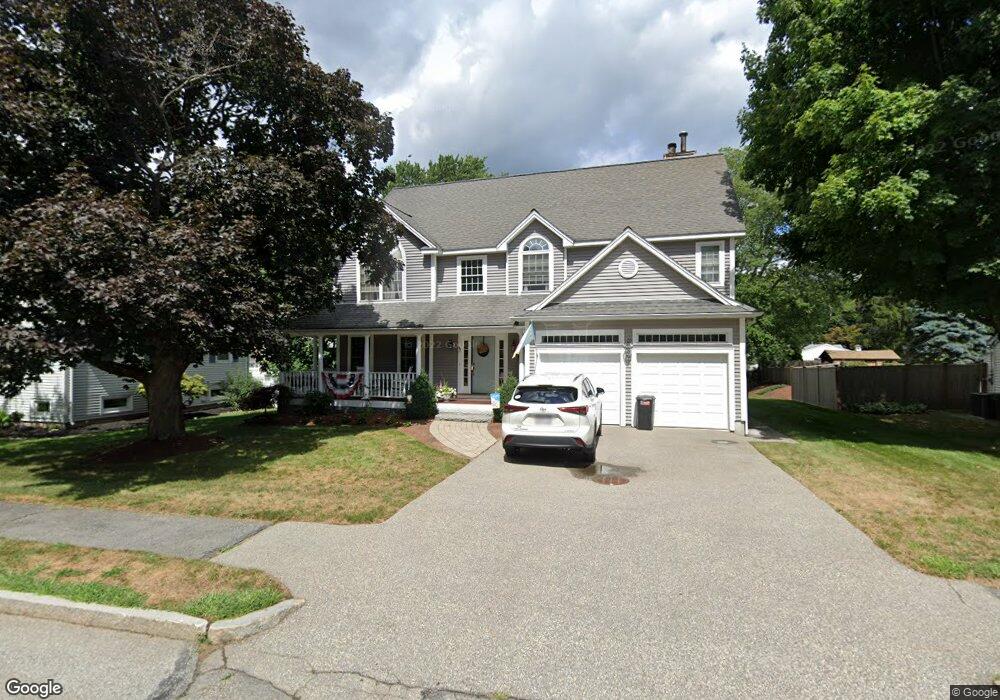
47 Berkley St Waltham, MA 02451
North Waltham NeighborhoodEstimated Value: $1,154,000 - $1,233,000
4
Beds
3
Baths
2,674
Sq Ft
$447/Sq Ft
Est. Value
About This Home
This home is located at 47 Berkley St, Waltham, MA 02451 and is currently estimated at $1,194,991, approximately $446 per square foot. 47 Berkley St is a home located in Middlesex County with nearby schools including Douglas Macarthur Elementary School, John F Kennedy Middle School, and Waltham Sr High School.
Ownership History
Date
Name
Owned For
Owner Type
Purchase Details
Closed on
Jan 22, 2025
Sold by
Oliveri Paula O and Oliveri Stephen V
Bought by
Oliveri Ft and Oliveri
Current Estimated Value
Purchase Details
Closed on
Oct 24, 1990
Sold by
Auld Douglas G
Bought by
Oliveri Stephen
Create a Home Valuation Report for This Property
The Home Valuation Report is an in-depth analysis detailing your home's value as well as a comparison with similar homes in the area
Home Values in the Area
Average Home Value in this Area
Purchase History
| Date | Buyer | Sale Price | Title Company |
|---|---|---|---|
| Oliveri Ft | -- | None Available | |
| Oliveri Stephen | $180,900 | -- |
Source: Public Records
Mortgage History
| Date | Status | Borrower | Loan Amount |
|---|---|---|---|
| Previous Owner | Oliveri Stephen | $400,000 | |
| Previous Owner | Oliveri Stephen | $429,000 | |
| Previous Owner | Oliveri Stephen | $362,000 |
Source: Public Records
Tax History Compared to Growth
Tax History
| Year | Tax Paid | Tax Assessment Tax Assessment Total Assessment is a certain percentage of the fair market value that is determined by local assessors to be the total taxable value of land and additions on the property. | Land | Improvement |
|---|---|---|---|---|
| 2025 | $10,164 | $1,035,000 | $489,500 | $545,500 |
| 2024 | $9,713 | $1,007,600 | $467,900 | $539,700 |
| 2023 | $9,613 | $931,500 | $424,500 | $507,000 |
| 2022 | $9,629 | $864,400 | $381,200 | $483,200 |
| 2021 | $276 | $843,200 | $381,200 | $462,000 |
| 2020 | $9,522 | $796,800 | $355,200 | $441,600 |
| 2019 | $9,095 | $718,400 | $350,900 | $367,500 |
| 2018 | $8,263 | $655,300 | $324,900 | $330,400 |
| 2017 | $7,850 | $625,000 | $294,600 | $330,400 |
| 2016 | $7,437 | $607,600 | $277,200 | $330,400 |
| 2015 | $7,278 | $554,300 | $242,600 | $311,700 |
Source: Public Records
Map
Nearby Homes
- 14 Benjamin Rd
- 1105 Lexington St Unit 102
- 15 Kings Way Unit 25
- 98 Seminole Ave
- 249 Lake St
- 234 Lake St
- 30 Wampum Ave
- 30 Jacqueline Rd Unit C
- 5 April Ln Unit 12
- 129 Lake St
- 463 Lincoln St
- 311 Concord Ave
- 102 Milner St
- 92 Milner St
- 28 Hillcrest St
- 14 Piedmont Ave
- 28 Goldencrest Ave
- 65 Montclair Ave
- 11 Autumn Ln
- 87 Clocktower Dr Unit 2207
- 39 Berkley St
- 55 Berkley St
- 69 Banbury Ave
- 77 Banbury Ave
- 150 Sheffield Rd
- 33 Berkley St
- 144 Sheffield Rd
- 48 Berkley St
- 40 Berkley St
- 55 Banbury Ave
- 138 Sheffield Rd
- 160 Sheffield Rd
- 34 Berkley St
- 62 Banbury Ave
- 27 Berkley St
- 70 Banbury Ave
- 130 Sheffield Rd
- 67 Brewster Rd
- 78 Banbury Ave
- 61 Brewster Rd