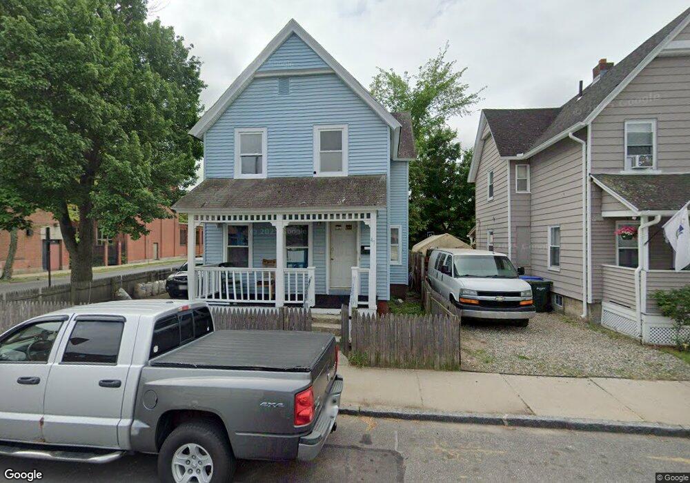
47 Ladd St Springfield, MA 01109
Old Hill NeighborhoodEstimated Value: $224,509 - $254,000
3
Beds
2
Baths
1,172
Sq Ft
$207/Sq Ft
Est. Value
About This Home
This home is located at 47 Ladd St, Springfield, MA 01109 and is currently estimated at $242,377, approximately $206 per square foot. 47 Ladd St is a home located in Hampden County with nearby schools including Mary A. Dryden Veterans Memorial School, M Marcus Kiley Middle, and High School Of Commerce.
Ownership History
Date
Name
Owned For
Owner Type
Purchase Details
Closed on
Dec 22, 2017
Sold by
Castillo Dave
Bought by
Gonzalez Juan J
Current Estimated Value
Purchase Details
Closed on
Mar 11, 2011
Sold by
Fnma
Bought by
Castillo Dave
Purchase Details
Closed on
May 11, 2010
Sold by
Mungin Earnest W
Bought by
Federal National Mortgage Association
Purchase Details
Closed on
Jun 15, 1990
Sold by
Nicholas Cecelia A
Bought by
Mungin Earnest W
Home Financials for this Owner
Home Financials are based on the most recent Mortgage that was taken out on this home.
Original Mortgage
$35,250
Interest Rate
10.54%
Mortgage Type
Purchase Money Mortgage
Create a Home Valuation Report for This Property
The Home Valuation Report is an in-depth analysis detailing your home's value as well as a comparison with similar homes in the area
Home Values in the Area
Average Home Value in this Area
Purchase History
| Date | Buyer | Sale Price | Title Company |
|---|---|---|---|
| Gonzalez Juan J | -- | -- | |
| Castillo Dave | $15,000 | -- | |
| Federal National Mortgage Association | $32,656 | -- | |
| Mungin Earnest W | $47,000 | -- |
Source: Public Records
Mortgage History
| Date | Status | Borrower | Loan Amount |
|---|---|---|---|
| Previous Owner | Mungin Earnest W | $18,231 | |
| Previous Owner | Mungin Earnest W | $35,250 |
Source: Public Records
Tax History
| Year | Tax Paid | Tax Assessment Tax Assessment Total Assessment is a certain percentage of the fair market value that is determined by local assessors to be the total taxable value of land and additions on the property. | Land | Improvement |
|---|---|---|---|---|
| 2025 | $3,098 | $197,600 | $23,200 | $174,400 |
| 2024 | $2,213 | $137,800 | $21,700 | $116,100 |
| 2023 | $2,141 | $125,600 | $20,700 | $104,900 |
| 2022 | $2,198 | $116,800 | $18,800 | $98,000 |
| 2021 | $2,100 | $111,100 | $17,100 | $94,000 |
| 2020 | $2,109 | $108,000 | $17,100 | $90,900 |
| 2019 | $2,049 | $104,100 | $17,100 | $87,000 |
| 2018 | $1,765 | $89,700 | $17,100 | $72,600 |
| 2017 | $1,878 | $95,500 | $13,700 | $81,800 |
| 2016 | $1,783 | $90,700 | $13,700 | $77,000 |
| 2015 | $1,707 | $86,800 | $13,700 | $73,100 |
Source: Public Records
Map
Nearby Homes
- 189 Northampton Ave
- 21 Westford Cir
- 0 Allen St (Ss)
- 10 Hemlock Ct
- 115-117 Northampton Ave
- 20 Hawthorne St
- 290 Quincy St
- 32 Clark St
- 15 Malden St
- 93 Pendleton Ave
- 0 NS (24) Alden St
- 21 Chester St
- 88 Agnes St
- 27 Chester St
- 118 Quincy St
- 42 Florence St
- 124-126 Westford Cir
- 85 Grand St
- 74 Cherry St
- 309 Island Pond Rd
Your Personal Tour Guide
Ask me questions while you tour the home.