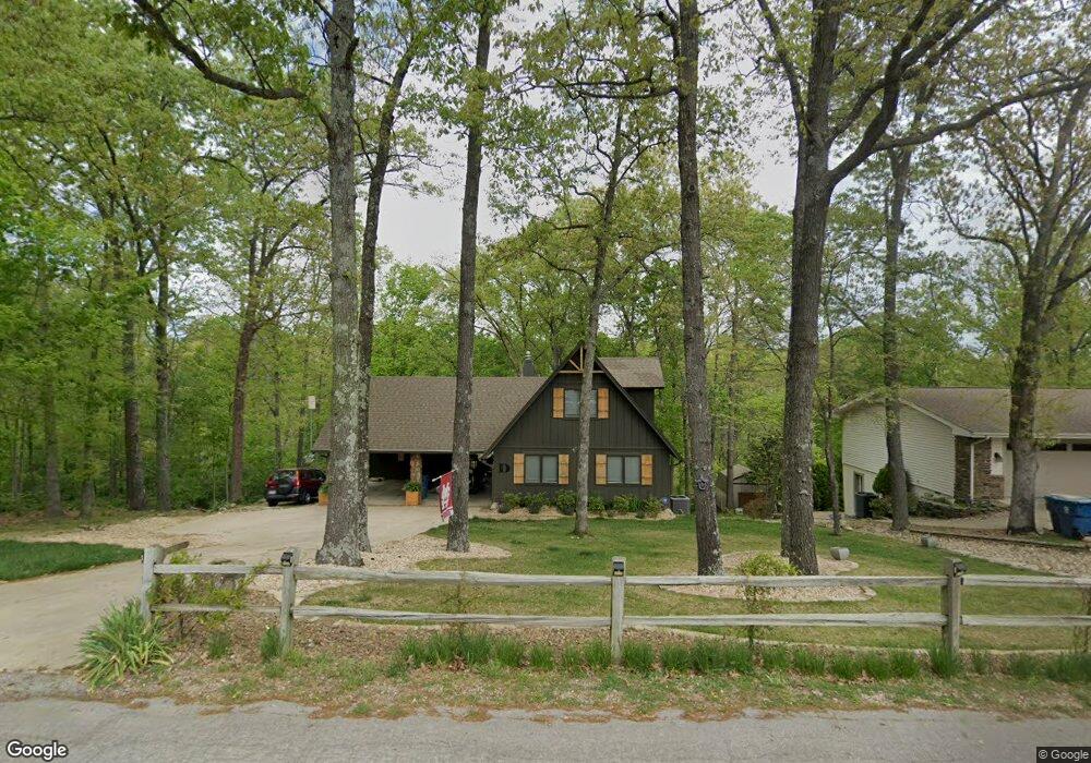
47 Mayfair Dr Bella Vista, AR 72715
Estimated Value: $305,000 - $622,828
4
Beds
3
Baths
2,850
Sq Ft
$180/Sq Ft
Est. Value
About This Home
This home is located at 47 Mayfair Dr, Bella Vista, AR 72715 and is currently estimated at $513,957, approximately $180 per square foot. 47 Mayfair Dr is a home located in Benton County with nearby schools including Cooper Elementary School, Old High Middle School, and Washington Junior High School.
Ownership History
Date
Name
Owned For
Owner Type
Purchase Details
Closed on
Sep 17, 2024
Sold by
Downey Kimbra and Downey Kimbra Lynn
Bought by
Downey Revocable Trust and Downey
Current Estimated Value
Purchase Details
Closed on
Jun 30, 2011
Sold by
Lackey Gerry Lynn
Bought by
Lackey Gerry L
Purchase Details
Closed on
Nov 19, 2002
Bought by
Lackey William Floyd
Purchase Details
Closed on
Jul 2, 1993
Bought by
Lackey
Purchase Details
Closed on
Oct 9, 1990
Bought by
Steward and Stevenson
Purchase Details
Closed on
Dec 3, 1976
Bought by
Larson
Create a Home Valuation Report for This Property
The Home Valuation Report is an in-depth analysis detailing your home's value as well as a comparison with similar homes in the area
Home Values in the Area
Average Home Value in this Area
Purchase History
| Date | Buyer | Sale Price | Title Company |
|---|---|---|---|
| Downey Revocable Trust | -- | None Listed On Document | |
| Lackey Gerry L | -- | None Available | |
| Lackey William Floyd | -- | -- | |
| Lackey | -- | -- | |
| Lackey | $120,000 | -- | |
| Steward | $105,000 | -- | |
| Larson | $14,000 | -- |
Source: Public Records
Tax History Compared to Growth
Tax History
| Year | Tax Paid | Tax Assessment Tax Assessment Total Assessment is a certain percentage of the fair market value that is determined by local assessors to be the total taxable value of land and additions on the property. | Land | Improvement |
|---|---|---|---|---|
| 2025 | $3,500 | $124,881 | $30,000 | $94,881 |
| 2024 | $3,184 | $124,881 | $30,000 | $94,881 |
| 2023 | $2,792 | $63,820 | $15,200 | $48,620 |
| 2022 | $2,661 | $63,820 | $15,200 | $48,620 |
| 2021 | $2,434 | $63,820 | $15,200 | $48,620 |
| 2020 | $2,233 | $46,450 | $13,200 | $33,250 |
| 2019 | $1,654 | $46,450 | $13,200 | $33,250 |
| 2018 | $1,679 | $46,450 | $13,200 | $33,250 |
| 2017 | $1,603 | $46,450 | $13,200 | $33,250 |
| 2016 | $1,603 | $46,450 | $13,200 | $33,250 |
| 2015 | $1,921 | $42,040 | $7,200 | $34,840 |
| 2014 | $1,571 | $42,040 | $7,200 | $34,840 |
Source: Public Records
Map
Nearby Homes
- 6 Neffwood Ln
- Lot 5 Neffwood Ln
- Lot 14 of Block 4 Heather Cir
- 30 Cromer Dr
- 50 Churchill Dr
- 19 Brompton Dr
- 26 Cromer Dr
- 0 Churchill Dr
- 6 Connie Ln
- 9 Connie Ln
- 36 Churchill Dr
- 17 Burnham Dr
- 21 Estes Dr
- 9 Estes Dr
- Lot 9 Swanage Dr
- 18 Gillingham Dr
- Lot 3, Block 3 Bridgeport Ln
- 22 Pembroke Ln
- 29 Gillingham Dr
- 7 Joanie Ln