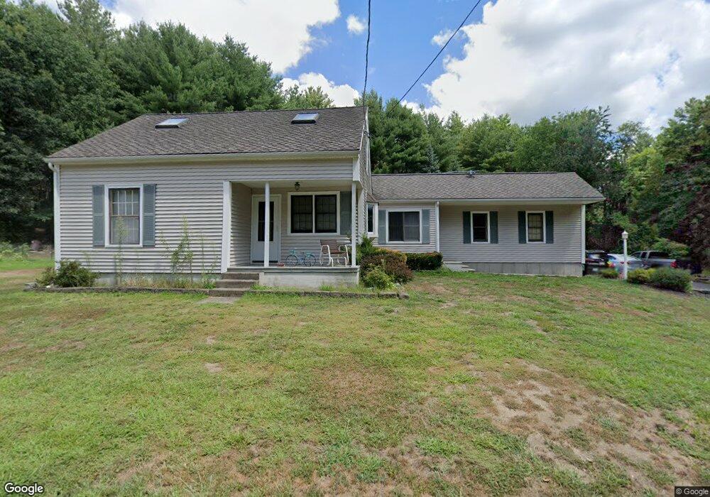
47 Mcquades Ln Northbridge, MA 01534
Estimated Value: $486,000 - $586,000
3
Beds
2
Baths
1,764
Sq Ft
$300/Sq Ft
Est. Value
About This Home
This home is located at 47 Mcquades Ln, Northbridge, MA 01534 and is currently estimated at $529,863, approximately $300 per square foot. 47 Mcquades Ln is a home located in Worcester County with nearby schools including Northbridge Elementary School, Northbridge Middle School, and Northbridge High School.
Ownership History
Date
Name
Owned For
Owner Type
Purchase Details
Closed on
Jan 8, 2010
Sold by
Leofanti Louis J
Bought by
Porcelli Carl A and Porcelli Jennifer A
Current Estimated Value
Home Financials for this Owner
Home Financials are based on the most recent Mortgage that was taken out on this home.
Original Mortgage
$250,381
Interest Rate
4.78%
Mortgage Type
Purchase Money Mortgage
Purchase Details
Closed on
Oct 31, 2002
Sold by
Pawlowski Edward and Pawlowski Janet Mantha
Bought by
Leofanti Louis J
Create a Home Valuation Report for This Property
The Home Valuation Report is an in-depth analysis detailing your home's value as well as a comparison with similar homes in the area
Home Values in the Area
Average Home Value in this Area
Purchase History
| Date | Buyer | Sale Price | Title Company |
|---|---|---|---|
| Porcelli Carl A | $255,000 | -- | |
| Porcelli Carl A | $255,000 | -- | |
| Leofanti Louis J | $288,000 | -- | |
| Leofanti Louis J | $288,000 | -- |
Source: Public Records
Mortgage History
| Date | Status | Borrower | Loan Amount |
|---|---|---|---|
| Open | Leofanti Louis J | $241,625 | |
| Closed | Porcelli Carl A | $250,381 |
Source: Public Records
Tax History Compared to Growth
Tax History
| Year | Tax Paid | Tax Assessment Tax Assessment Total Assessment is a certain percentage of the fair market value that is determined by local assessors to be the total taxable value of land and additions on the property. | Land | Improvement |
|---|---|---|---|---|
| 2025 | $5,337 | $452,700 | $148,100 | $304,600 |
| 2024 | $4,980 | $411,900 | $148,100 | $263,800 |
| 2023 | $4,907 | $378,600 | $140,300 | $238,300 |
| 2022 | $4,529 | $328,900 | $108,000 | $220,900 |
| 2021 | $4,385 | $302,600 | $102,900 | $199,700 |
| 2020 | $4,070 | $294,100 | $102,900 | $191,200 |
| 2019 | $3,654 | $281,700 | $102,900 | $178,800 |
| 2018 | $3,472 | $268,300 | $97,900 | $170,400 |
| 2017 | $3,460 | $255,700 | $97,900 | $157,800 |
| 2016 | $3,207 | $233,200 | $84,000 | $149,200 |
| 2015 | $3,097 | $231,500 | $84,000 | $147,500 |
| 2014 | $3,070 | $231,500 | $84,000 | $147,500 |
Source: Public Records
Map
Nearby Homes
- 2767 Providence Rd
- 86 Mikes Way Unit 86
- 84 Mikes Way Unit 84
- 19 Milford Rd
- 395 Providence Rd Unit 4
- 79-81 Upton St
- 58 Buttercup Ln
- 61 Tulip Cir
- 89 Buttercup Ln Unit 255
- 151 Fowler Rd
- 150 Sprague St
- 1880 Providence Rd
- 119 Susanne Dr
- 1825 Quaker St
- 27 Fowler St
- 1076 Hill St
- 191 Hartness Rd
- 3 Driscoll Ln
- 18 Leland St
- 0 Puddon St
- 51 Mcquades Ln
- 41 Mcquades Ln
- 49 Mcquades Ln
- 46 Mcquades Ln
- 55 Mcquades Ln
- 42 Mcquades Ln
- 17 Mcquades Ln
- 17 Mcquades Ln Unit 1
- 48 Mcquades Ln
- 24 Mcquades Ln
- 14 Mcquades Ln
- 51 Raymond Ave
- 2636 Providence Rd
- 42 Raymond Ave
- 2648 Providence Rd
- 2626 Providence Rd
- 2620 Providence Rd
- 47 Raymond Ave
- 2686 Providence Rd
- 35 Raymond Ave