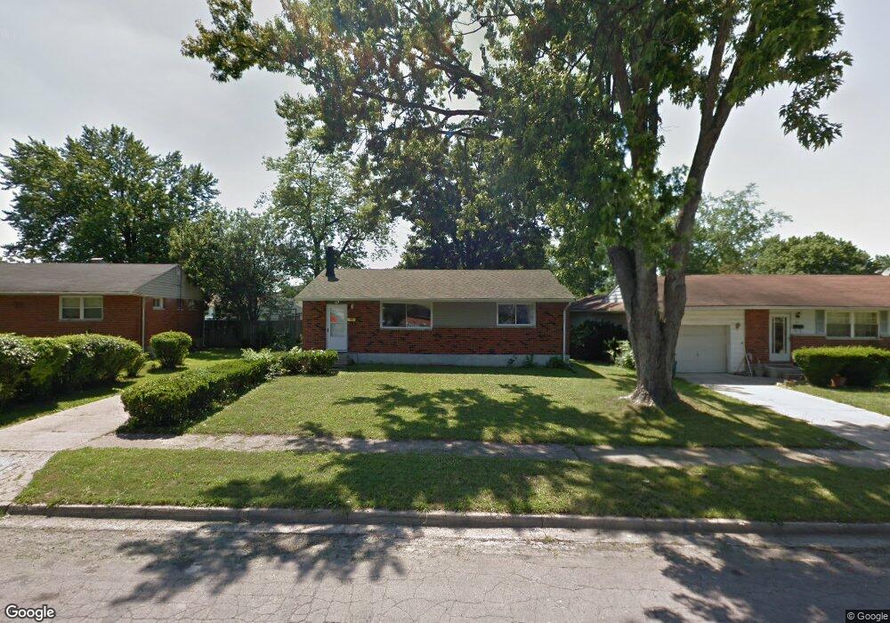
47 Nona Dr Dayton, OH 45426
Estimated Value: $115,000 - $131,000
3
Beds
1
Bath
1,100
Sq Ft
$114/Sq Ft
Est. Value
About This Home
This home is located at 47 Nona Dr, Dayton, OH 45426 and is currently estimated at $125,604, approximately $114 per square foot. 47 Nona Dr is a home located in Montgomery County with nearby schools including Trotwood-Madison Middle School, Trotwood-Madison High School, and Trotwood Preparatory & Fitness Academy.
Ownership History
Date
Name
Owned For
Owner Type
Purchase Details
Closed on
Jun 28, 2018
Sold by
Montgomery County Land Reutilization Cor
Bought by
Evers Jason
Current Estimated Value
Purchase Details
Closed on
Oct 18, 2017
Sold by
Richardson Hank
Bought by
Montomery County Land Reutilizati
Purchase Details
Closed on
Nov 30, 2006
Sold by
Wells Fargo Bank Na
Bought by
Richardson Hank
Purchase Details
Closed on
Jun 5, 2006
Sold by
Delph Mark
Bought by
Wells Fargo Bank Na and Option One Mortgage Loan Trust 2001-B As
Purchase Details
Closed on
May 4, 2001
Sold by
Delph Mark D and Delph Sharon K
Bought by
Delph Ii Mark
Home Financials for this Owner
Home Financials are based on the most recent Mortgage that was taken out on this home.
Original Mortgage
$56,000
Interest Rate
7.95%
Create a Home Valuation Report for This Property
The Home Valuation Report is an in-depth analysis detailing your home's value as well as a comparison with similar homes in the area
Home Values in the Area
Average Home Value in this Area
Purchase History
| Date | Buyer | Sale Price | Title Company |
|---|---|---|---|
| Evers Jason | -- | Performance Title Inc | |
| Montomery County Land Reutilizati | -- | -- | |
| Richardson Hank | $30,000 | Accutitle Agency Inc | |
| Wells Fargo Bank Na | $38,000 | None Available | |
| Delph Ii Mark | $70,000 | Tower City Title Agency Inc |
Source: Public Records
Mortgage History
| Date | Status | Borrower | Loan Amount |
|---|---|---|---|
| Previous Owner | Delph Ii Mark | $56,000 |
Source: Public Records
Tax History Compared to Growth
Tax History
| Year | Tax Paid | Tax Assessment Tax Assessment Total Assessment is a certain percentage of the fair market value that is determined by local assessors to be the total taxable value of land and additions on the property. | Land | Improvement |
|---|---|---|---|---|
| 2024 | $1,476 | $22,040 | $4,480 | $17,560 |
| 2023 | $1,476 | $22,040 | $4,480 | $17,560 |
| 2022 | $1,483 | $17,240 | $3,500 | $13,740 |
| 2021 | $1,485 | $17,240 | $3,500 | $13,740 |
| 2020 | $1,483 | $17,240 | $3,500 | $13,740 |
| 2019 | $1,402 | $13,150 | $2,450 | $10,700 |
| 2018 | $23 | $14,200 | $3,500 | $10,700 |
| 2017 | $23 | $14,200 | $3,500 | $10,700 |
| 2016 | $2,193 | $13,600 | $3,500 | $10,100 |
| 2015 | $1,283 | $13,600 | $3,500 | $10,100 |
| 2014 | $1,283 | $13,600 | $3,500 | $10,100 |
| 2012 | -- | $20,130 | $5,430 | $14,700 |
Source: Public Records
Map
Nearby Homes
- 33 Mario Dr
- 204 E Main St
- 4 Pleasant Ave
- 17 Grand Ave
- 17 N Sunrise Ave
- 103 E Worley Ave
- 0 Main
- 1 E Worley Ave
- 209 W Main St
- 208 E Sunrise Ave
- 301 Beardsley Rd
- 385 Blairwood Dr
- 208 E Eppington Dr
- 717 Mapleside Dr
- 512 N Sherry Dr
- 7540 Tuscola Dr
- 6899 Little Richmond Rd
- 4051 Belmore Trace
- 800 Chandler Dr
- 0 Little Richmond Rd